-
 43293 Hits
-
 88.54% Score
-
 27 Votes
|
|
Mountain/Rock |
|---|---|
|
|
33.83830°N / 117.171°W |
|
|
Riverside Country |
|
|
Trad Climbing, Sport Climbing, Toprope |
|
|
Spring, Summer, Fall, Winter |
|
|
1640 ft / 500 m |
|
|
Overview
Within the Inland Empire of southern California, Lake Perris lies just south of the city of Riverside and approximately 70 miles north of San Diego. Sandwiched between the barren boulder-strewn Russell Mountains and Bernsconi Hills, this lake boasts mostly water sports, camping and a bit of hiking and mountain biking, and has also been the scene of several triathlons in the past several years.Within the park's boundaries, what seems to be a forlorn and dry dust-bowl at water's edge, is actually a natural wonder of flora and fuana.... and granite!
Big Rock does not lend to the wondering mind of epic multi-pitch trad routes, but better used for a closer to the city weekday rock fix and a perfect wall for beginners. The wall's nearly 20 routes are nearly all bolted sporty climbs between 30'-160'. Very few trad routes exist, Rat Crack 5.9, for example and is fairly short of being classic. Routes range from 5.1 to 5.11c and most can be top-roped either by a first lead or hiking to the top of the rock from either far end (also can be used as descent).
The elite and avid climber will most likely not enjoy a day spent at Big Rock, but it does serve a wonderful purpose for learning "the ropes," an afternoon "quickie," or even some free soloing.
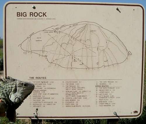 Helpful sign with routes and grades listed.
Getting There
Located in Riverside County of Southern California, inland between Riverside and San Diego. Coming from the south (San Diego) on I-215N, prior to reaching Hwy 60, take exit going east on Ramona Expressway toward Lake Perris. Approximately 6 miles later, just around a left hand curve, take a left turn onto Bernasconi Road into the Lake Perris Park entrance. As of 2006, there has been no ranger at the booth but an integrity charge of $8 for parking in the park. You can choose to be a cheapskate and park outside gate boundary and walk an extra quarter mile to the rock face. If parking alongside entrance road, please take all items out of view in vehicle, big scene of break-ins. Coming from the north along Route 91, take the I-215 south and exit the Ramona Expressway heading east to Lake Perris.Once in the gate of Lake Perris Park, go past the booth and take the first left road, continue past another gate and onto a wide dirt path that follows along the lake shore on the right and rock faces on the left. Approximately a quarter mile down the road, there will be port-a-potties and a large sign with Big Rock information and routes shown. Picnic tables and trash cans are under the large tree just at the base of the most popular routes.
Red Tape
No permits required, only an $8 entry fee. I tried to be slick and not submit payment in the box, this resulted in an $85 ticket!Speaking of "red" - WATCH OUT FOR POISON OAK mainly at base of south facing wall.
When To Climb
Big Rock can be climbed year round as long as you can tolerate heat/cold at the peak of seasons. The wall is mainly southwest facing and gets loads of afternoon and evening sun.Best times to climb are summer month mornings prior to 1100. As the sun peaks over the summit, you will be blinded and eventually scorched. Late in the afternoons and early evenings are also nice conditions with a slight breeze to take the sweat off.
The wintertime afternoons are wonderfully sunny and nearly warm. Climbing shoes love it.
This slab can become extremely crowded on weekends, spring and summer. Quite large groups of beginners and weekend warriors with multiple strands of ropes in every direction. Takes patience to hit this crag on a weekend!
[img:50594:aligncenter:medium:Crowds can get thick on weekends and some climbers have been known to hiss.]
Camping
At this time, camping has been restored. Port-a-potties and BBQ pits are available.Camping at Lake Perris.
Mountain Conditions
Check intellicast.com website for the city of Perris conditions, or NOAA link below.Mountain weather conditions.
infernal doom fanati - May 20, 2005 12:14 pm - Hasn't voted
Untitled CommentThree other trad routes exist at Big Rock.
The first is Upper Crack 5.4, Left Flake 5.6 (quite sublime!) and Right Flake 5.7. All three of these routes add a great second pitch to compliment The Roof 5.9, Boogaloo 5.9, Wedunnit 5.6, and Crater Maker 5.7. The latter two require a traverse that's not too hairy but exciting none the less.