Overview
Rising up along the southern ramparts of the "Ripsaw Ridge", Peak G dominates over Bubble Lake in pyramidical fashion. Hosting one of the last remaining glaciers in Colorado on it's lower slopes, Peak G is a beautiful peak located in the northern portion of the Gore Range of West Central Colorado. This peak along with it's neighbor Peak F are the most difficult peaks to climb along this ridge due to their steep, loose, and rugged approaches along with some bushwacking and 4th class final summit pitches.
Peak G
Not high enough to be included in the "fourteeners", highest 100, or highest 200, Peak G is a seldom climbed peak. There are no guidebooks containing routes, there are no trails or cairned routes to the summit, and there is no name listed on any USGS map. These facts along with the challenge, the beauty of the mountain, and the spectacular view from the summit, beckon seasoned mountaineers to conquer its heights.
Although Peak G is a seldom climbed peak, it is not a remote peak. The peak is only 17 miles from I-70 and the resort town of Vail and only 7 miles from the trailhead. Peak G is only a 2 and 1/2 hour drive from Denver. It is located in close proximity to the highest peak in the Gores, Mt. Powell. This peak is located in the Eagle Nest Wilderness which is located within the White River National Forest.
Peak G is located on the southern end of Ripsaw Ridge just south of it's neighbor, Peak F. This extremely rugged ridge contains several 13,000 ft. peaks and would make a challenging endeavor for anyone wishing to conquer it. A traverse from Peak C to G would be a challenging and demanding day hike from the trailhead (see also Peak E) . Please do not attempt this peak if you are not a very experienced climber.
Getting There
Take I-70 west from Denver to the resort town of Vail. I-70 will be stop and go at times between Denver and Silverthorne on a busy weekend. Take Exit 176 and drive North on the service road 1 mile. Take a right turn on Red Sandstone Rd. (County Road 701) and drive 11 miles on a 2x2 road. The first 1/2 mile or so is paved. The first 5 miles isn't too bad except for the washboard if they haven't grated the road in a while. The next 5 miles is passable for any car but is very rough because of NUMEROUS potholes. During the busy tourist season, you may get behind slow moving vehicles making their way to Piney Creek Ranch. Get an early start to avoid the crowded road.
Ripsaw Ridge

Peak F is located along the southern portions of an extremely rugged and challenging ridge know to locals as "Ripsaw Ridge." As the name suggests, this ridge is extremely jagged and contains 5 peaks over 13,000 ft. and several more points that also rise over 13,000 ft. For those who like ridge scrambling, this is for you; however, the loose nature of the rock makes this very dangerous. Approach this ridge with extreme care. Depending on your routefinding skills, this ridge will most likely take you into some class 5 climbing. Downclimbing to the west will avoid some of the technical difficulties but it will also require you to lose valuable elevation.
FOR A VIEW FROM THE OTHER SIDE OF RIPSAW RIDGE, CLICK HERE.
Red Tape
No permits or fees are required. There is a climbers and hikers parking lot just before entering into the Piney Creek Ranch. There should be plenty of room to park.
Like all wilderness areas no mechanized or motorized vehicles are permitted within the Eagles Nest boundaries.
For more information, contact the U.S. Forest Service at the # below:
USDA Forest Service
White River
National Forest
900 Grand Ave.
P.O. Box 948
Glenwood Springs CO 81602
970-945-2521
White River National Forest Home Page
Additional Resources:
Western Portion of the Wilderness:
Holy Cross Ranger District
P.O. Box 190, 24747 US HWY 24
Minturn, CO, 81645, Phone: 970-827-5715
or
Eastern Portion of the Wilderness:
Dillon Ranger District
680 River Parkway
Silverthorne, CO 80498
970-468-5400
Information on avalanche conditions:
Colorado Avalanche Information Center
Current fire restrictions:
Colorado Office of Emergency Management
When To Climb
Mid-June to mid-September is the best time to climb in the Gore Range. Trailhead access and the rugged terrain would make this peak very difficult in the winter. Avalanche danger would be a huge concern.
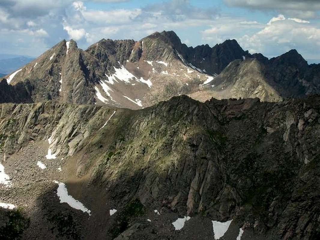
Peak G (center) Photo copyright by Kane.
Camping
There are several areas to camp on the road up to the Piney Creek Ranch. The first place is about 5 miles up on the left hand side of the road. The last mile also has several places to camp although the dust factor could get pretty bad. There are also plenty of areas between the trailhead and the turnoff to Peak G to camp.
Mountain Conditions

Images
|