
-
 35558 Hits
-
 96.98% Score
-
 64 Votes
|
|
Mountain/Rock |
|---|---|
|
|
48.66500°N / 113.4°W |
|
|
Hiking, Mountaineering, Scrambling |
|
|
Spring, Summer, Fall, Winter |
|
|
8665 ft / 2641 m |
|
|
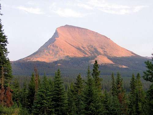
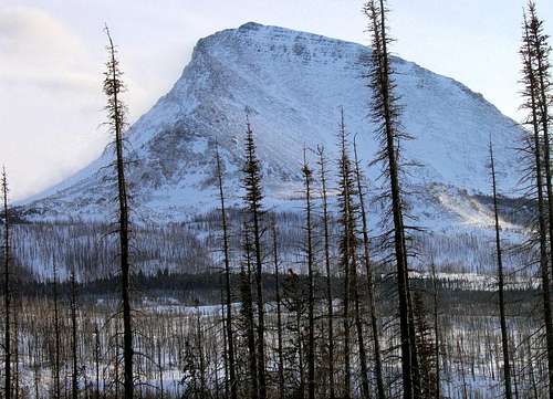
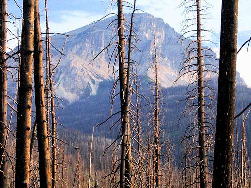
CRUCIBLE A beautiful, simple landscape. A beautiful, simple landscape.The mountain rises easily above any recording of what might be deemed important, will do so long after the emotions, the physical scars, have merged with and become part of what it is that becomes not remembered with the passage of years. What happened will not live forever in the annals of memory, but only flame briefly (and even then not be the kind of import known over great distances, but will, rather, be the flickering moment of a relatively small area), a pithy note to be read as life goes on to other things. But for now—today, and a few tomorrows—what happened is indeed paramount. A great and important life ended here, a town came oh-so-close to being wiped out by fire that took a dense forest and insisted it begin again...and now we look at this mountain, and it is not the same as before.
Partly, it is an emotional vision that swirls, but also, of course, there are the realities of that oldest of all stories, and how do you give face to that of which at times it seems we understand next to nothing? Life and death has its way, Divide Mountain—immovable, intractable—rises almost gently above the fray while on its flanks we catalogue the contributions of J. Gordon Edwards, thankful for his life while simultaneously mourning his passing. That alone would be enough, but there is more, as a mere two years on, for a few days the Red Eagle Fire obliterated this part of the world, and there is no mourning whatsoever at its passing; as a result of those days of fire, vision to the mountain has been cleared through the trees, and a new forest is under construction. The crucible bubbles, ebbs, flows—an inconstant thing in our minds—while the mountain stands as a calm and beautiful anchor amidst emotional frenzy. J. GORDON EDWARDS—MOUNTAIN MAN WITHOUT PEER
 A fitting light in which to reflect on the life of J. Gordon Edwards. A fitting light in which to reflect on the life of J. Gordon Edwards. Honor and Remembrance. Honor and Remembrance.Every mountain has a history, and let it be said that with the death of J. Gordon Edwards on July 19, 2004, the records of this strikingly elegant peak on the eastern boundary of Glacier National Park have taken on a new and poignant depth. Gordon Edwards was the greatest chronicler of a great area, and to those of us leaving our cars and actually climbing these peaks, his recorded thoughts on the matter, A Climber's Guide to Glacier National Park, is absolutely indispensable. It is the better part of a life's work, a work of love for an area that can at times be completely overwhelming, and he has made these mountains, if not readily accessible, at least approachable. So it ends here, of natural causes on the lower slopes of Divide Mountain; not in the park's great interior but on its edge; not on one of the towering summits, but on an approach; not dramatically but by all accounts quietly, and this mountain, in the human way we have of reflection, is now quite special. 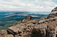 The article was posted in this structure. The article was posted in this structure.Edwards was one of the founders of the Glacier Mountaineering Society, which lists 266 official peaks in the Glacier-Waterton International Peace Park (plus an additional 22 that are "unofficial"), of which he pioneered routes up more (some say considerably more) than 70 of them. There is nothing in the Continental U.S. like this area; it is very big and very tall, at times seemingly impenetrable, and he did all of it with grace and style—and then showed us how to do it. He was incredible. I don't know what more a man could be expected to do with his life.... * * * * * * * * * I came across many, many sources of information regarding Edwards, of which, naturally enough, much of what was written is repetitive from article to article, but I think this, and then this to be the two best, and are worth your time. There are many unnamed peaks in Glacier National Park.
FRIDAY, JULY 28, 2006
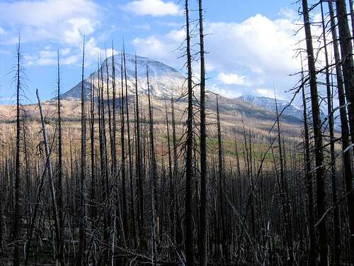
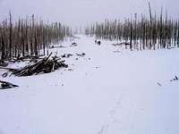
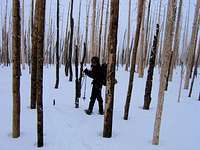
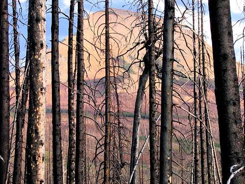
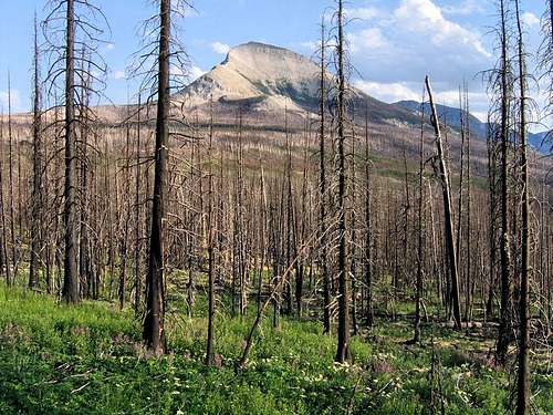
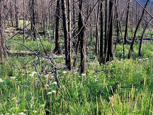
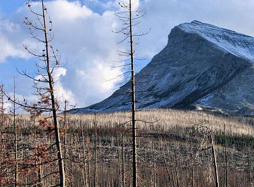
 Nothing left... Nothing left...(Enlarge this)  Looking through the tangled mess... Looking through the tangled mess...Any big fire runs from time to time, and during these periods nothing much can be done except get out of the way, then stand back and (rather helplessly) watch the show. The Red Eagle Fire didn't so much run as explode across the landscape; during that first Saturday night and Sunday flames reached 200' into the air, and pushed by 50 mph winds through thick, at times insect-killed, timber, went from its origins to over 22,000 acres—more than 35 square miles! Red Eagle was a living thing moving quickly, effortlessly, lithly, not singly but thickets of trees at a time through drainage after drainage, noisely (a big fire at full cry is...elemental, unforgettable), like jet engines streaming low across the treetops—something in its magnificence not to be touched (and most certainly not contained!) but only feared (it bears repeating: get out of the way!). Respected. Prayed against. Red Eagle was a monster, beautiful and terrifying and etched unforgettably across the minds of those fortunate enough—or unfortunate enough—to be within visual reach of its lair. 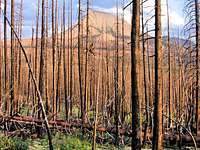 Warm July light asks, was it really that bad? Warm July light asks, was it really that bad?For an historical blink-of-an-eye, in this place the fire was everything—this place, in which the town of St. Mary, small and helpless against the onslaught, was evacuated...only to have the beast turn a mile short of annihilation, choosing instead another victim, and now the timber stands of the Blackfeet Nation will not be the same in this lifetime. But even hell needs fuel to survive, and thus it was that Red Eagle did itself in by devouring everything in its path; moving on rails of dried forest and wind, the omnivore simply found itself out of food. The ending was neither graceful nor quick, but one of bluster and threats, occasional wind and sparks, and always, enough smoke to warn of a giant, still-dangerous thing in its death throes. Finally, at 34,000 acres and six or seven weeks reign, the terror was gone, perishing with early winter snows. The monster had done that which was foreordained, leaving a savaged, pregnant landscape in its wake, with only the natural leavening of sun, wind, and sky to deal with charred forest.
LANDSCAPES LIKE THESE DIDN'T EXIST BEFORE THE FIRE.
A FIRE ON THIS SCALE IS NOT SOMETHING THAT LEAVES YOUR MIND....
OVERVIEW
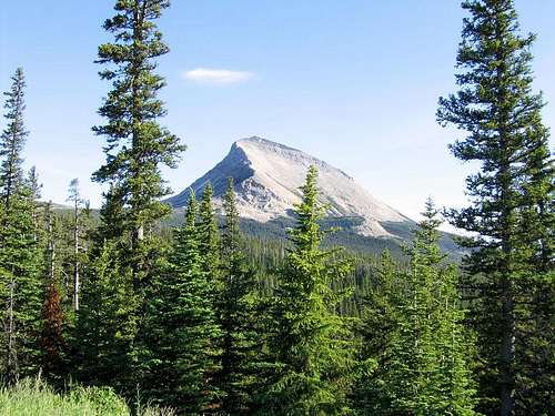
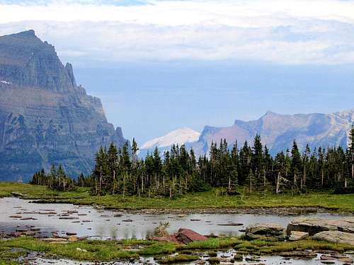
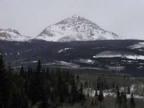
 A "...graceful, unassuming mountain." A "...graceful, unassuming mountain." Divide, White Calf, Kupunkamint. Divide, White Calf, Kupunkamint.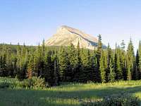 Forest, mountain, morning light... Forest, mountain, morning light...GNP doesn't have very many "easy" mountains, but there are a couple, which make for relaxing days between longer, more difficult, peaks, or which can be done when weather makes the lengthier ascents risky, or they can be done simply as a good first, non-stressful, introduction to climbing in the park. Divide Mountain is one of these (Mount Oberlin is another). It can be climbed in about an hour-and-a half from vehicle to summit, and despite the "easy" status of the mountain, views from the top are very fine indeed! The peak sits on the eastern boundary of GNP and the Rocky Mountains. In this part of the country the upthrust edge between plains and mountains is called the Rocky Mountain Front (in Colorado it is known as the Front Range); from the summit can be seen the Saint Mary area of GNP, as well as peaks further north, all the way to Yellow Mountain, which is in the Many Glacier area; views into the southern and south central parts of the park are very good, and a bit unusual in perspective, and to the east and northeast are the plains, seemingly running off into forever and Canada and Eastern Montana. The climb is well worth the effort!
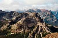
VIEWS FROM—AND TO—THE MOUNTAIN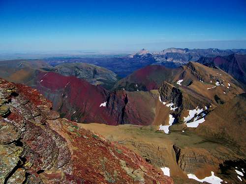 From Mount Siyeh, Divide Mountain in a landscape. From Mount Siyeh, Divide Mountain in a landscape.
 Billboard referred to in text. Billboard referred to in text.
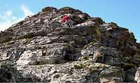
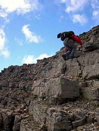
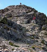
GETTING THERE Overview of road in... Overview of road in...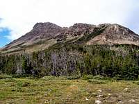 Close to the trailhead. Close to the trailhead. "This mountain climbs fast." "This mountain climbs fast."Standard cautionary note here: All GNP roads are closed in winter, with Going-to-the-Sun Road (the major route through the park; its eastern terminus is at Saint Mary) sometimes not opening until July (average opening is second week in June; earliest opening ever was May 16, 1987, with the second earliest being May 22, 2005). Don't head out early in the year (i.e., June/early July) without checking the status of these roads—it is not unusual to have repeated, sometimes lengthy, road closures due to storms, avalanches, rock slides, or all three! The same holds true for late in the year; weather changes dramatically, beginning usually around the end of August, with road closures normally becoming more and more frequent through the month of September (although don't let that shy you away from going, there can also be very nice—albeit cool or cold—days of Indian Summer throughout this time frame; plus the park is relatively free of people after Labor Day—just always carefully check the weather). Map of Waterton/Glacier International Peace Park (Note that clicking on the image after it loads brings up a larger version, making it MUCH easier to read.) GNP Road Information: Current Road Status And finally, click here for current information, as well as easy access to some interesting photos showing the Plowing of Going-to-the-Sun Road. ROUTE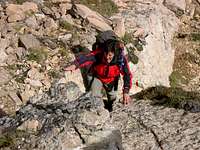 Easy scramble, class 2 terrain. Easy scramble, class 2 terrain.
WHEN TO CLIMB, & CLIMBING CONSIDERATIONS
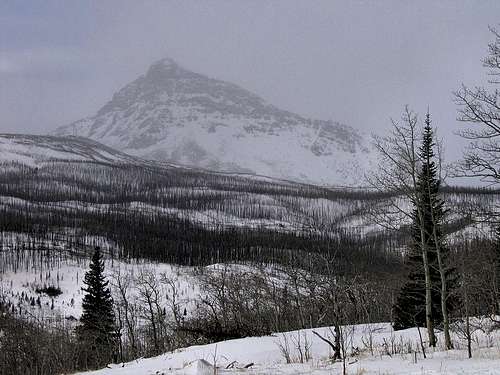
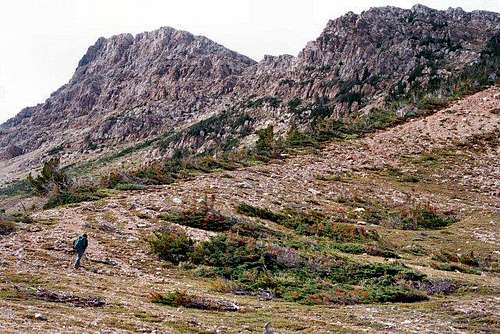
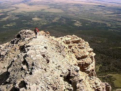
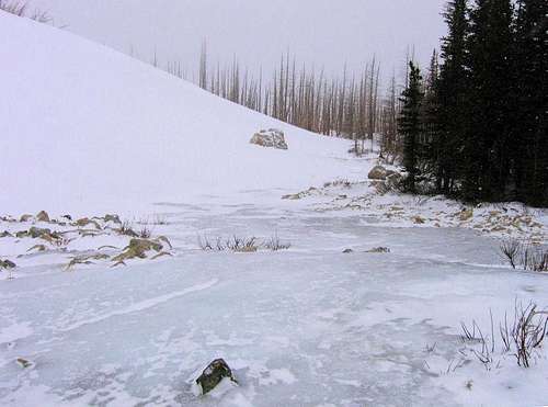
 Almost at the access point. Almost at the access point. From the summit, looking west into the park. From the summit, looking west into the park.Okay, having said all that...Divide Mountain is one of the few GNP peaks upon which a winter ascent would not be considered unreasonable. The mountain sits such that the almost constant winds scour the ridge-top route free of snow, with very little—if any—cornicing. Snow does, of course, collect in bowls and sheltered areas, making, as far as we could see on our scouting excursions, the most problematical portion of the entire climb being the access onto the mountain proper. It probably goes without saying, but I will do so anyway: during the winter the approximately two miles driven during a summer effort will require skis or snow shoes, and leg work. [img:379922:alignleft:small:Almost at the access point.] Anyone used to winter outings in mountain terrain knows that often a successful ascent is merely a lucky happenstance with weather, so I won't belabor the point that winter in this area is something that must be carefully dealt with. It is cold here, and snowy...and is extremely windy, often all at the same time. In February of 2006, nearby Marias Pass had an official wind gust of 160 mph—when checking the weather for a climb, you MUST pay attention to the wind velocity projections! The towns of East Glacier Park and Browning have year-round lodging and restaurants; nearby St. Mary is pretty much a ghost town during winter. CLIMBING CONSIDERATIONS Because of the nature of the rock, there are special considerations regarding climbing in Glacier National Park, and grading systems unique to the Park have been developed by both J. Gordon Edwards and the Glacier Mountaineering Society. Anyone doing more than just "trail" hiking in this part of the Rockies should read the excellent and important information put together by Fred and Moni Spicker. Much—if not most—of the rock in GNP is sedimentary and rotten, and you need to know about it: Glacier National Park Rock & Grading Systems. THE RED TAPE, CAUTIONS, & WILDLIFE SECTION
CAMPING
MOUNTAIN CONDITIONS/WEB CAMSWeather page—an overview, plus current conditions and forecast This is the New NPS Web Cam Page.
EXTERNAL LINKS/ADDITIONAL INFORMATION/ITEMS OF RELATED INTEREST
In TributeOn March 1, 2011, Vernon Garner, Saintgrizzly, left us after losing a bold, inspiring fight against pancreatic cancer. Or maybe he won, for he is at last free of his pain and has "shuffle[d] off this mortal coil."Vernon was an important contributor on SummitPost, but beyond merely making good, informative pages, he actually inspired many who read his work. No one put more work into his or her pages than Vernon did, and many of those pages, especially those related to Glacier National Park, the place he loved above all others, are works of art in both the writing and layout. More than one person has wanted to visit Glacier or go back to Glacier largely due to what he shared about that magnificent place. Many people on SP counted Vernon among their friends, and many more saw him as one of the best, one of those who exemplified the spirit of this site. He was one of the best of us, he will be missed, and he will not be forgotten. As a tribute to him, Vernon's pages will remain in his name. Any member who sees a need for an addition or correction should please contact site management via the "Send PM to the Elves" feature. Rest well and climb on, Vernon.
TABLE OF CONTENTS
Additions and CorrectionsPost an Addition or Correction |


FlatheadNative - Jul 9, 2010 9:40 am - Voted 10/10
Route statsVernon...what are the trip distance and elevation gain for Divide? I looked for the data but did not find it.
FlatheadNative - Jul 12, 2010 1:31 am - Voted 10/10
Re: Route statsMy GPS read the distance and elevation gain as: 1.143 miles and about 1,889 feet elevation gain. Not a easy as Oberlin and the first 1/4 is pretty challenging for climbers that are not in good shape.