
|
|
Mountain/Rock |
|---|---|
|
|
40.72200°N / 110.118°W |
|
|
Duchesne |
|
|
12425 ft / 3787 m |
|
|
Overview
As with many of the peaks in the Uinta Mountains, “West Clover Mountain” does not have an official name. "West Clover Mountain" is the highest point not far west of the Clover Benchmark and is at 12,425 feet elevation with 663 feet of prominence above the connecting saddle.Because of its proximity to the benchmark and because the benchmark is on a subsidiary peak, the name West Clover is the one most commonly used for this peak.
The ridge West Clover is a part of contains three ranked 12,000+ foot peaks. "North Cleve" sits as the highest point on the ridge between Fox Queant Pass to where the ridge fades away into the timber several miles to the south. “Penny Nickell Peak” and “West Clover Peak” are the other ranked 12,000+ foot peaks along the ridge. All three peaks lie on the same ridge between the upper Uinta River drainage and the West Fork Whiterocks River drainage. There are actually several summits on the ridge, but these three have over 300 foot prominence from the connecting saddles and would be considered individual peaks by most standards.
These peaks in this area are rounded and not as rugged as some of the peaks in the Northeast Uintas, but are worthwhile destinations. These peaks are almost never visited, but are some of the easier to access 12'ers in the Uinta Mountains. The mountain itself isn’t overly rugged, but does have some steep cliffs and cirque basins surrounding the peak. The standard routes are walk ups, but there is boulder-hopping involved. Further, while most of the 12'ers in the Uinta Mountains require multi-day approaches, you can climb several peaks here in a really long one-day hike.
Like all peaks in the Uinta Mountains, except for Bald Mountain, West Clover Mountain has no trail to the summit. It can be climbed on a very long day trip, but the area is surrounded by many nice backcountry campsites in the basins and around the fishing lakes.
The Uinta Mountains are one of the few mountain ranges in North America that run east to west rather than north to south. Within the Uinta Mountains are about 2000 lakes, and some 900-1000 are full of trout. Along with the San Juan Mountains in Colorado, the Uinta Mountains have more contiguous area above timberline than any other area in the Continental United States. This is a beautiful area with many lakes, meadows, wildflowers, and some rugged peaks. Solitude is usually easy to come by once you leave the popular fishing holes behind.
The Uinta Mountains are very rugged in the northeast section. Beginning at Hayden Peak and east to Mount Lovenia, the Uinta Mountains are not unlike the Tetons or other ranges. East of Lovenia, the peaks are more gentle, with a few rugged peaks (i.e. Red Castle and Henrys Fork Peak) scattered about until you are as far east as the Henrys Fork/Kings Peak area. East of Kings Peak, the Uinta Mountains become very gentle and the peaks are very rounded with only a few scattered cliffs about.
This is a beautiful area with many lakes, meadows, wildflowers, and some rugged peaks. Solitude is usually easy to come by once you leave the popular fishing holes behind.
Utah's 12,000+ Foot Peaks With 200+ Feet Prominence
Utah's 12,000+ Foot Peaks With 300+ Feet Prominence
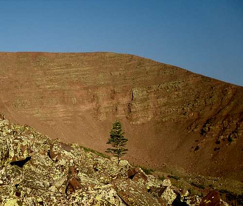 Clover Benchmark (12335') viewed from the east.
Getting There
There are several driving routes to the trailhead, but this is the quickest. A good road map is needed.From Roosevelt, take State Highway 121 north. This is where the elbow in Highway 40 is, right downtown, so the turnoff is easy to locate. Stay on Highway 121 north, follow it as is makes a sharp turn at Neola and heads due east. The highway will reach a "T" and turn south. At the "T", turn left (north) to the town of Whiterocks. From Whiterocks, drive northwest along the paved road. Not long after passing the fish hatchery, will be another junction. Go straight (not left). The road heads north, then east, then north again. At the next intersection, go straight and to the Elkhorn Guard Station.
Turn left and continue on the Elkhorn Loop Road, up Pole Mountain, and to Forest Road 110 before heading to Pole Creek Lake. Don't take the Elkhorn Loop to Pole Creek Lake, but turn right onto Forest Road 110. If you reach Pole Creek Lake, you overshot the turnoff. Follow Forest Road 110 north for about four miles to the signed (for West Fork Whiterocks Trailhead) turnoff to the left. Turn left to the trailhead. Most of the Elkhorn Loop as well as Forest Road 110 is gravel, but usually in good condition for cars, provided you drive slowly.
 A moose as seen along the West Fork Whiterocks River.
Routes Overview
These are overviews only. See the route pages for much more detail.The Northeast Ridge of the Clover benchmark then west to the summit is the most practical route. From the West Fork Trailhead, you actually cross some rough logging roads. If you can find the beginning of the roads, you can probably shorten the hike with a 4wd, but I didn't try driving them, or using another trailhead, since I didn't know they existed until crossing them on the way to the peaks.
The easiest route up "West Clover" actually appears to be from the south from Pole Creek Lake and then the Rock Creek Lakes, but I haven't tried this route, so you will have to explore the route on your own. The northwest ridge of peak leads to Peak 12,127/"Penny Nickell Peak" and can be used to climb all three, or two peaks in one shot.
Note: Apparently a blowdown storm has effected the routes through the forest to timberline on West Clover (according to the other summit log). It wasn't there in 1992 or in August 1995, but on Flat Top Benchmark (south of Emmons) we found one in August 1997 that caused route problems. It was probably the same storm, and it must have happened sometime between those dates. If you have updated route info, please post.
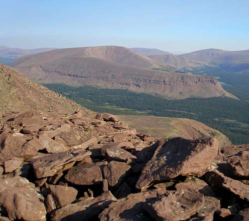
 ower portion of the northeast ridge of Clover Benchmark.
The Grand Tour
It is possible to climb all three peaks mentioned above in one shot. From the trailhead, you will climb over West Clover, Penny Nickel and North Cleve Peaks. up to Fox-Quent Pass. This is a great route if no thunderstorms are present, but be aware that you will be above the timberline for a long distance, and this area receives many electrical storms. Don't attempt it if there are and thunderstorms present. This route can be done in one very long day for a strong climber.
 Cleve Benchmark (12514') with its distinctive long arm viewed from the West Clover/Clover Benchmark ridge.
Red Tape
No permits are required.When To Climb
July through September is the normal hiking/climbing season here. Mosquitoes can be especially thick in July. Winter road closures are a really long way from the trailhead, and climbing these peaks would require well over a week's time when the roads are closed. It is highly probable that these peaks haven't yet seen a winter ascent. If you did try it, I would estimate that it may take ten days or so. Fox Quent Pass, to the north of West Clover as seen in mid August.
Camping
There are many good campsites on the access road to the trailhead.The peak is surrounded by many beautiful backcountry campsites as well. Queant Lake is beautiful, but is the most popular camping place in the area, so if you want something more quiet, it is better to find somewhere else. Cleveland Lake is also fairly popular as well.
If climbing West Clover only, it would be a fairly short route to do as a backpacking trip since most campsites would be located not far from the trailhead.
 "West Clover" from Cleveland Lake.
Mountain Conditions
Weather Forecast for Central Uinta MountainsHere are some average highs and lows from the 12,139 foot elevation (3700 meters) in the Uintas (about the same altitude as the summit):
| MONTH | HIGH | LOW |
| JAN | 14 | -1 |
| FEB | 16 | 1 |
| MAR | 19 | 4 |
| APR | 27 | 11 |
| MAY | 35 | 18 |
| JUN | 45 | 25 |
| JUL | 55 | 32 |
| AUG | 53 | 31 |
| SEP | 45 | 24 |
| OCT | 34 | 15 |
| NOV | 22 | 8 |
| DEC | 17 | 3 |