
-
 15079 Hits
-
 90.69% Score
-
 33 Votes
|
|
Route |
|---|---|
|
|
37.27820°N / 112.9396°W |
|
|
Overview
Much of the text on this page is by the original author, who lost interest in maintaining the page. As the information was accurate and good, I have changed and added very little.Observation Point lives up to its name as perhaps the best trail-accessible viewpoint of Zion Canyon in Zion National Park in southern Utah. It is frequently summited via a Class 1 trail which climbs approximately 2,150 feet in an 8-mile round-trip route from the Weeping Rock shuttle stop on the Canyon floor.
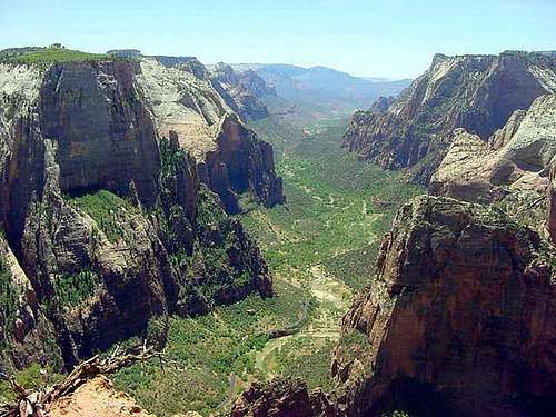
![Wide view of Zion Canyon from...]()
Panoramic view of Zion Canyon from Observation Point. That's the top of Angel's Landing on the right.
Zion National Park has implemented a mandatory shuttle system. You park at the Visitor's Center at the south end of the Canyon and catch one of the shuttle buses. You will get off the shuttle at the Weeping Rock stop.
Current shuttle details should be verified at the Zion National Park website: Zion National Park homepage.
Be aware that from late spring to early fall, this hike can be brutal with temperatures at or above 100 degrees. Carry plenty of water and sunscreen and remember your hat!
Zion National Park has a human history dating back to the Anasazi people about 2,000 years ago. There is evidence that the Paiutes were here approximately 800 years ago. The Mormons, who gave the area the name Zion for its beauty, arrived here in the 1860's.
Zion was first incorporated as a national monument in 1918 and became a national park on November 19, 1919. In 1920 there were a reported 3,692 visitors to the park. Today an average year sees approximately 2.5 million visitors.
This information was excerpted from Park brochures.
Although it is often referred to as a summit, it really is not one and is a view point instead. Very close by is a summit: Observation BM, which offers some different views and is rarely "climbed" even though it is very close to Observation Point and just minutes off the very popular trail.
Panoramic view of Zion Canyon from Observation Point. That's the top of Angel's Landing on the right.
Getting There
Zion National Park is surprisingly close to Interstate 15. Just north of St. George, Utah, take the Highway 9 east exit, which will take you directly to the park. If you have an extra few days, visit the north rim of the Grand Canyon, which is only a few hours to the south and gives a different perspective of the big ditch.Zion National Park has implemented a mandatory shuttle system. You park at the Visitor's Center at the south end of the Canyon and catch one of the shuttle buses. You will get off the shuttle at the Weeping Rock stop.
Current shuttle details should be verified at the Zion National Park website: Zion National Park homepage.
Route Description
Being in a National Park makes this route fairly obvious with all trail junctions signed and good trail the whole way. Just follow the signs and make sure to bring your park map and a compass.
You will head up from the trailhead and quickly pass the left turn to Weeping Rock. Continue straight and switch back up into Echo Canyon. This portion of the trail is steep and features seemingly countless switchbacks, but there are awesome views to compensate.
You will head up from the trailhead and quickly pass the left turn to Weeping Rock. Continue straight and switch back up into Echo Canyon. This portion of the trail is steep and features seemingly countless switchbacks, but there are awesome views to compensate.
The first major trail junction heads right to Hidden Canyon (a beautiful side trip) and left to Observation Point. The second major trail junction heads right on the East Rim Trail and left to Observation Point; before reaching this junction, one passes through beautiful Echo Canyon, which in many places narrows to a slot (hikers do not go through the actual slots, though). The third major trail junction heads right on the East Mesa Trail and left to Observation Point.
Red Tape
An entry fee is charged by the National Park Service to enter Zion National Park. Current fees and restrictions should be verified at the Zion National Park website: Zion National Park homepage.When To Climb
Observation Point is a Class 1 hike but has some areas where the trail is only 8'-10' wide with a vertical drop off making hiking in inclement weather potentially deadly. Fortunately, Zion National Park receives little moisture and little snow, though there often are snowbanks on the switchbacks leafing up to Echo Canyon winter through early spring.Weather conditions can be verified at the Ranger's Desk at the Visitor's Center, which you will have to park by to access the park shuttle.Be aware that from late spring to early fall, this hike can be brutal with temperatures at or above 100 degrees. Carry plenty of water and sunscreen and remember your hat!
Camping
There are pay campgrounds located in Zion National Park and backcountry permits for backpack camping are available. Detailed information can be found at the Zion National Park website: Zion National Park homepageMountain Conditions
Check local weather at: Zion National Park weatherAbout Zion National Park
Zion National Park is a 229 square-mile park in southwest Utah. The park claims to have the world's largest natural arch, Kolob Arch, located in the park's northern section. Elevations in the park range from 3,666 feet to 8,726 feet.Zion National Park has a human history dating back to the Anasazi people about 2,000 years ago. There is evidence that the Paiutes were here approximately 800 years ago. The Mormons, who gave the area the name Zion for its beauty, arrived here in the 1860's.
Zion was first incorporated as a national monument in 1918 and became a national park on November 19, 1919. In 1920 there were a reported 3,692 visitors to the park. Today an average year sees approximately 2.5 million visitors.
This information was excerpted from Park brochures.