
|
|
Route |
|---|---|
|
|
37.21485°N / 112.93907°W |
|
|
Hiking |
|
|
Spring, Summer, Fall, Winter |
|
|
Less than two hours |
|
|
Hike |
|
|
Overview
Clear Creek has carved a beautiful slickrock valley in the eastern parts of Zion National Park. Visitors who enter the park from the east, travel on Route 9 through this scenic valley. Between the park’s east entrance and the Zion-Mt. Carmel Tunnel, Route 9 provides access to many side valleys and canyons that drain into the Clear Creek Valley. While exploring some of the canyons requires technical skills, many of the valleys can be hiked. With the exception of Canyon Overlook Trail, however, there are no established trails and no signs on the road for these hikes.Shelf Canyon is a short hike that allows you to explore a slot canyon without the need for technical skills. The canyon sits on the north side of Route 9 just before the eastern entrance of the Zion-Mt. Carmel Tunnel. It can be hiked/bushwhacked for less than half a mile. As you hike up the canyon, you will note that it becomes narrower until it turns into a slot canyon wide enough for only one hiker. Further up, you will note debris filling the bottom of the canyon and will eventually reach a series of shelves that mark the end of the hike.
 Map |
Getting There
Please note that there are no signs on the road for this hike. It is obviously very important that you identify and enter the correct canyon. Study your map carefully. The GPS coordinates below may also be helpful.Drive on Route 9 to the eastern entrance of the Zion Mt. Carmel Tunnel (The long tunnel). You will see a sign and parking area for the Canyon Overlook Trail (There is actually a parking spot on the south side of the road just before the tunnel entrance and another one on the north side a little farther to the east). Almost everyone who parks here heads west to reach the trailhead for the Canyon Overlook Trail. You must head east along Route 9 and depending on where you parked, walk 150-300 yards to reach the entrance of the Shelf Canyon.
GPS Coordinates for the entrance into the Shelf Canyon from Route 9 are:
37 degree, 12.891 minute North
112 degree, 56.344 minute West
Route Description
Hike Statistics: My GPS did not work in this canyon. It took me 50 minutes to do the hike (less than a mile roundtrip). Trailhead elevation is 5150 ft and the elevation at the end of the hike is probably 5400 ft.At the mouth of Shelf Canyon, you will note a number of hoodoos on the left (west) side of the canyon. Descend a short distance below the road embankment and enter the canyon.
 Mouth of the Canyon |
The floor of the canyon may be sandy or made of slickrock.
 |  |
You will often have to bushwhack your way around the many obstacles.
 Bushwhacking |  Bushwhacking |
In some place you can look up to see the walls of the canyon rising straight above you.
 Wall of the Canyon |
As you keep going, the canyon keeps getting narrower.
 |
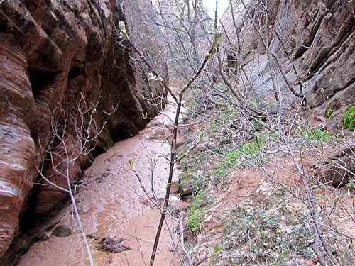 |
 |
You will then reach a slot canyon. Farther up, much debris makes the progress difficult. This is the end of the hike.
 Slot Canyon |
 Slot Canyon |
 Debris in Slot Canyon |
Weather
See the forecast for Springdale, UTRed Tape
Day hikes do not need a permit.When I checked with the Back Country Desk at the park headquarters, I was told that day hikes into non-technical canyons do not need a permit. I recommend that you personally check with the park before hiking.
See link below for all rules and regulations:
http://www.nps.gov/zion/index.htm