
-
 15785 Hits
-
 83.19% Score
-
 17 Votes
|
|
Mountain/Rock |
|---|---|
|
|
47.70346°N / 12.01210°E |
|
|
Hiking, Mountaineering |
|
|
Spring, Summer, Fall, Winter |
|
|
6030 ft / 1838 m |
|
|
Overview
WENDELSTEIN is a mountain in the Bavarian Pre-Alps in Germany. It belongs to the "Mangfallgebirge" the eastern part of the Bavarian Pre-Alps. It is the highest summit of the same named range. From top you have a wonderful summit-view, because the Wendelstein stands more alone than the mountains around it. So it won´t astonished that it is one of the most visited sightseeing summits of this region. You can reach the summit also by train which starts in GROSSBRANNENBURG oder by cablecar from OSTERHOFEN nearby BAYRISCHZELL. On top there are a transmitter of the regional TV-station "Bayrischer Rundfunk", a observatory, a chapel and a meteorological station. The summit is very rocky and consists of lime.
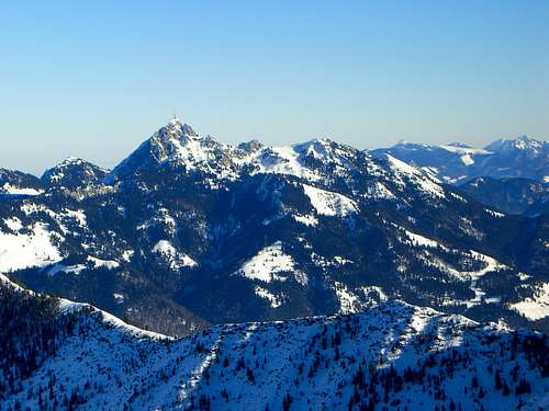 Wendelstein seen from Benzingspitz nearby Jaegerkamp at Spitzingsee.
Getting There
This section describes the way to the parking at SUDELFELD, the ski region next to WENDELSTEIN where the normal-route to the summit starts.From North: On A8 (german highway #8) to highwaycrossing "Inntal-Dreieck". Then southward on A93 (german highway #93) to the exit #58 "Brannenburg" and continuing to GROSSBRANNENBURG where the Wendelstein-train starts. After that you reach TAZLWURM, a pass which guides to SUDELFELD.
From South: On A8 (german highway #8) leaving at the exit #59 "Oberaudorf" and continuing eastward to Tazlwurm and Sudelfeld.
Nearest Airport:
Munich Airport
Innsbruck Airport
German Railroad Company "Deutsche Bahn AG"
When To Climb: Weather, Webcam and general Informations

WEATHER IN THIS REGION (Bayrischzell)
DANGER OF AVALANCHES BAVARIA
Wendelstein-Obversatory
"Wendelsteinbahn" - Train and Cablecar
Webcam of Wendelstein
Tourism Upper Bavaria
Homepage of the town Bayrischzell
Homepage of the town Brannenburg
Ski-region Sudelfeld


Routes to Wendelstein
SUMMIT: Latitude: 47.70346° N ; Longitude: 12.01214° E1)
Normal-Route to Wendelstein: From parking Sudelfeld on a asphaltic way towards Larcheralm / Larcheralpe, then on the track "B1d" via Wendelsteinalm to Zeller Scharte and continuing to the summit. (2,3/4h)
2)
In winter it is very popular to ascent by train or cablecar and ski down from the summit southward into the Larcherkar.
 Chapel
Joerg Marretsch - May 14, 2006 2:16 pm - Voted 9/10
Latitude / LongitudeLatitude: 47° 42.500' N Longitude: 12° 00.800' E
Sebastian Hamm - May 16, 2006 5:28 am - Hasn't voted
Re: Latitude / LongitudeMerci Dir, Hast du die Koordinaten auch in "DD.MMMMM/DD.MMMMM"? Bei manchen GPS-Geräten muss man nur kurz die Einstellung ändern, dann bekommt man auch die genaueren Werte zu den bereits gespeicherten. Salü Sebastian
Joerg Marretsch - May 17, 2006 7:14 pm - Voted 9/10
Re: Latitude / LongitudeHi Sebastian, leider habe ich nur diesen Wert vom letzten Jahr (ist auch ein einfaches GPS, muß nochmal die Anleitung studieren). Was meinst Du genau mit DD.MMMMMM/DD.MMMMMM ? Ich kann Dir die Werte der Minuten auch in Minuten und Sekunden getrennt ausgeben. Viel andere bekannte Optionen sehe ich beim etrex Summit nicht (habs gerade vor mir liegen). Gruß - Jörg
Sebastian Hamm - May 18, 2006 6:51 am - Hasn't voted
Re: Latitude / LongitudeHi Jörg, In SP werden die Koordinaten am besten nur mit Grad angegeben, zumindest können diese Werte dann automatisch in die Karten eingefügt werden. Die Unterteilung in Grad/Minuten/Sekunden oder nur Grad und Minuten ist daher nicht sinnvoll, da diese Werte auch wesentlich ungenauer sind. Ich mußte mich da auch umstellen, ist aber wesentlich leichter. In SP werden die Koordinaten einfach nur in Grad (5stellig hinter dem Komma) angeben. Damit kann man jedes Grad in 100.000 Einheiten unterteilen. Bei dem anderen Modus (Min + Sek) kann man ja nur 60' und 60'' angeben werden, was ja weniger als die 100.000 Einheiten sind. Ich mußte mich bei meinem GPS-Gerät auch durch die Einstellungen klicken, bis ich diese gefunden habe. Ich kann Dir gerade nicht sagen, wie diese heißt, da ich mich auf Dienstreise befinde, am Wochenende kann ich es in meinem Gerät nachschauen. Die gespeicherten Werte (Min+Sek) wurden bei mir sogar dann einfach umgewandelt. Die Geräte scheinen die exaktere Methode intern automatisch zu benutzen. Mein Gerät ist mit das billigste, Magellan Explorist 100, dann wird es bei Dir wahrscheinlich auch funktionieren. Schönen Gruss und Salü Sebastian PS: Schau mal meine Seite "Brecherspitz", da siehste die Koordinaten und die Umwandlung in der Karte. Als ich mit deinen Werten experimentiert habe bin ich immer im Zillertal rausgekommen ;-) - Habe deine Koordinaten jedoch in den Text "Routes to Wendelstein" eingefügt.
Joerg Marretsch - May 20, 2006 12:55 pm - Voted 9/10
Re: Latitude / LongitudeHallo Sebastian, habe die Einstellung für die Gradanzeige gemäß Summitpost.org an meinem GPS gefunden. Bei der nächsten Tour werde ich die Werte für den Wendelstein entsprechend aktualisieren (da Speicher voll, sind die alten Werte nicht mehr drin). Gruß aus Oberbayern - Jörg
Sebastian Hamm - May 20, 2006 8:31 pm - Hasn't voted
Re: Latitude / LongitudeHi joerg, Herzlichen Dank ! Salü Sebastian
Joerg Marretsch - Jun 11, 2006 9:16 am - Voted 9/10
Re: Latitude / LongitudeHallo Sebastian, war gestern oben: Breite: 47.70346° N Länge: 12.01214° E Gruß - Jörg
Sebastian Hamm - Jun 11, 2006 10:30 am - Hasn't voted
Re: Latitude / LongitudeHabe deine Bilder gerade gesehen. Hast ja perfektes Wetter gehabt. Werde die Koordinaten gleich einbauen. Wünsche Dir noch weitere sonnige Bergtage. Bei mir dauert es noch ein paar Wochen. Salü Sebastian