
-
 7214 Hits
-
 82.48% Score
-
 15 Votes
|
|
Mountain/Rock |
|---|---|
|
|
47.60090°N / 11.86172°E |
|
|
Hiking, Scrambling, Via Ferrata, Skiing |
|
|
Summer, Fall, Winter |
|
|
5932 ft / 1808 m |
|
|
Overview
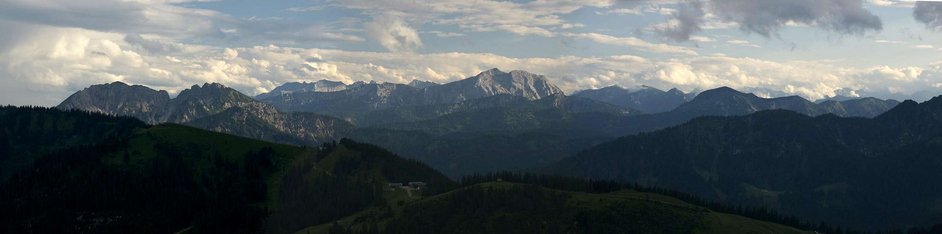
 Schinder seen from Brecherspitz Schinder seen from Brecherspitz |
Schinder is a twin peaked mountain, located on the border between Germany and Austria. Indeed, its two summits, which are separated by a distance of some 700m, are located on opposite sides of the border. The lower western summit, Bayerischer (Bavarian) Schinder reaches 1796m, while the higher eastern summit, Östereichischer (Austrian) Schinder (also Trausnitzberg) reaches 1808m. Thanks to its location and depending whom you ask, the mountain also appears to belong to two mountain ranges: the Bavarian Prealps or the Rofan / Mangfallgebirge. As the higher summit is on Austrian ground most likely the latter definition is most likely correct and is used by most authors.
 |  |  |
While Schinder surely cannot be called a high mountain, nevertheless it stands out among its neighbours. This is mainly due to the fact that it is a solitary mountain, not connected by any ridge to any of its neighbours. More important, however, is the fact that its two summit bear a dolomite ressemblance, especially when seen from the north. Schinder is a limestone mountain and the steep faces as well as the huge scree fields bear witness to that fact.
 |  |  |  |
To the north the two summits with their ridges form a horseshoe-like cirque: Schinderkar. Here you can find the biggest scree slope of them all, which comes down from the saddle between the summits. While it is mostly used for descent only - difficult enough in the upper section - it also forms a good winter ski tour route. From my own experience I can only warn to do it in summer conditions. The whole scree field is constantly shifting and there are few places with firm ground underneath. The main attraction of this route, however, is the rock window at its top, a bit underneath the saddle. Here the route is protected by cables and worn ropes as well as pins to scale the steepest sections. The final ascent follows the west ridge of Östereichischer Schinder and is also protected by cables in several places.
  |
In contrast the normal route to the mountain is just that: normal. It follows the south slopes of the mountain which are far less impressive than the east and west ridges.
 |  |  |
The Bavarian summit of Schinder (Bayerischer Schnider) can easily be climbed starting from Schinder col, the huge col between the two summits of Schinder.
Reach the col via the north ascent of Schinderkar or descend from Österreichischer Schinder via the west ridge.
Alternatively climb the col on the south route coming from Bayralm (bike and hike tour).
To reach the summit take the narrow trail traversing the south slopes west of Schinder col (don´t descend in the direction of Rieselsberg Alm) and ascend the very steep and narrow trail up the meadow and dwarf pine slopes until you reach the ridge crest.
Left of you is a summit with a small summit cross, right of you is the highest point of Bayerischer Schinder.
The route is a bit easier than the west ridge to Österreichischer Schinder as there are no rock scrambles and fixed ropes. The trail is exposed, though!
Good views to the North, west and south. The views to the east are better when seen from Österreichischer Schinder.
The name Schinder is hard to translate, though everyone, who has tried ascending the mountain through the Schinderkar Cirque will tell you it fits like a glove. The dictionary tells me that the British word is knacker, someone who exploits dead animals. From that use the meaning has evolved to exploiter and opressor of people. The reflexive verb (sich schinden) is often used for people who drive themselves like mad to reach their goal - and the Schinderkar ascent certainly fits that description.
Getting There
 Looking out of Schinderkar from close to Schindertor
Schinder is located in the triangle between Munich, Innsbruck and Salzburg. The trailhead can be most easily accessed from the north, even if you start at Innsbruck in the south-west.
- From Munich or Salzburg take motorway A8
- Leave at the exit Holzkirchen (97) and turn onto B318
- Follow the signs to Tegernsee, switching to B307
- In Rottach-Egern turn left onto the toll road through the valley of Rote Valepp
- There is a parking space near the confluence of Rote Valepp and Weiße Valepp.
- You can also reach this point from Spitzingsee (either by bus) or by a 90 minute hike along a road which is closed for traffic.
Red Tape
There is no red tape here. However, the mountain is located directly on the border between Germany and Austria. Make sure to carry an ID even though the borders in Europe are open now.Accommodation
Trausnitzalm, which is located at 1420m on the normal route to Östereichischer Schinder is a farmstead where you can get something to drink. There's no food or accommodation available there.- Schliersee / Spitzingsee accommodation
- Tegernsee accommodation
Weather Conditions
Maps & Books
Maps
- Bayrischzell
Kompass Map WK008
1:35000
ISBN: 978-3-85491-352-8
- Tegernsee - Schliersee<
Topographic Map UK 2
1:25000
ISBN: 3-86038-001-X
- Mangfallgebirge
Topographic Map UK L12
1:50000
ISBN: 3-86038-484-8
Books
- Hiking
- Leichte Wanderungen in den bayerischen Voralpen
Heinrich Bauregger
J. Berg Verlag
ISBN: 978-3765840609
- Leichte Wanderungen in den bayerischen Voralpen
- Ski Touring / Snow Shoeing
- Winterwanderungen in den bayrischen Voralpen
Heinrich Bauregger
J. Berg Verlag
ISBN: 978-3765840784
- Winterwanderungen in den bayrischen Voralpen
Additions and CorrectionsPost an Addition or Correction
- Bayrischzell
selinunte01 - Jun 1, 2015 7:19 am - Voted 10/10
Short ascent to Bayerischer SchinderThe Bavarian summit of Schinder can easily be climbed starting from Schinder col, the huge col between the two summits of Schinder. Reach the col via the north ascent of Schinderkar or descend from Österreichischer Schinder via the west ridge. Alternatively climb the col on the south route coming from Bayralm (bike and hike tour). To reach the summit take the narrow trail traversing the south slopes west of Schinder col (don´t descend in the direction of Rieselsberg Alm) and ascend the very steep and narrow trail up the meadow and dwarf pine slopes until you reach the ridge crest. Left of you is a summit with a small summit cross, right of you is the highest point of Bayerischer Schinder. The route is a bit easier than the west ridge to Österreichischer Schinder as there are no rock scrambles and fixed ropes. The trail is exposed, though! Good views to the North, west and south. The views to the east are better when seen from Österreichischer Schinder.