
|
|
Mountain/Rock |
|---|---|
|
|
47.10004°N / 12.30469°E |
|
|
Hiking, Mountaineering, Ice Climbing, Mixed, Scrambling, Skiing |
|
|
Spring, Summer, Fall, Winter |
|
|
11024 ft / 3360 m |
|
|
Overview
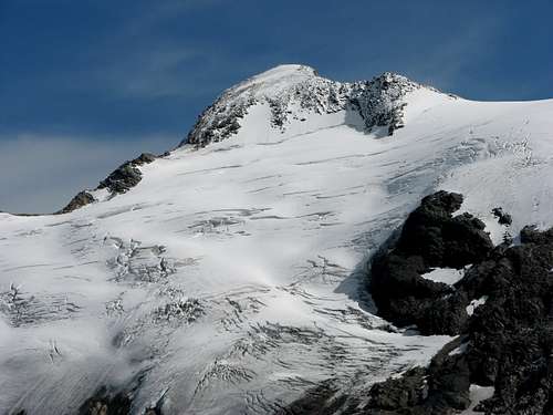
 Grossvenediger, 3667m and below Grosser Geiger, 3360m.
Grosser Geiger, 3360m is a mountain that belongs to the Venediger group. It is located in the main ridge of the Venediger group. From all sides it is well known because of its pyramid form surrounded with large glaciers. For this area is characteristic that below the mountains are huge glaciers with big crevasses and seracs.
On the north side there is a huge glacier called Obersulzbachkees. It is located below the north faces of Maurerkeeskopf, 3313m, Grosser Geiger, 3360m , Grossvenediger, 3667m and some other mountains. Over this glacier go the north approaches to the summit of Geiger. On the east side is below the east face the glacier Dorferkees. And on the south side the glacier Maurerkees. All the glaciers are very large and have many crevasses.
Grosser Geiger has four big ridges. The north ridge falls down to the glacier Obersulzbachkees. The northeast ridge falls down to the notch Obersulzbachtörl, 2921m and then continues to the summit of Grossvenediger. The west ridge continues to the summits of Maurerkeeskopf and the south ridge goes to the summit of Grosser Happ, 3350m. This long ridge falls then over the many small mountains to the valley Virgental.
 Grosser Geiger south side.
For Grosser Geiger are typical long approaches. First you must reach huts through the long valleys and then over the large glaciers you reach the upper faces of Geiger. For more information check the Routes overview section.
View from Grosser Geiger
 Grossvenediger, 3667m seen from Grosser Geiger, 3360m.
The view from Grosser Geiger is beautiful. All the giants of Hohe Tauern group can be seen, the Dolomites and someother big groups in the Alps. Specially the view on Grossvenediger, 3667m is amazing.
Getting There
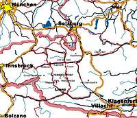 Location map.
Getting there depends on in which valley you want to start your trip.
South approach
For the south approach you have to follow the road until Matrei, then the Virgental to the end of the valley to the village Streden, 1403m where there is a parking place. You have to pay 3 euros for one day or 9 euros for one week.
Southeast approach
For this approach you park the car in the village Hinterbichl, 1329m and you reach the hut Johannishuette, 2121m by walk or you use via Taxi Venediger. This is also very popular ascent to Johannishuette because there goes the main approach on Grossvenediger.
North approach
For the north approach you have to go to the Salzach valley until Neukirchen (941 m)otherwise follwing the Felbertauern-Road through the tunnel. You can hire a taxi to the Postalm, 1699m. You must park you car in the Hopffeldboden, 1080 m.
 Overview map of Venediger group.
Maps
Alpenvereinskarte (Map of the german/austrian alpine club) 1:25.000 Nr. 36 Venedigergruppe.
Route Overview
Here is an overview of the routes on Grosser Geiger. Walking on the glacier Maurerkees.
South route: From the valley Maurer Tal by the hut Essener-Rostocker, 2208m and then over the glacier Maurerkess to the top. You reach the top from the glacier over the SW face or over the south ridge. Description.
Southeast route: The starting point is the village Hinterbichl, 1329m From the valley Dorfer Tal to the hut Johannishuette, 2121m and then through the valley between the Grosser Geiger and Grossvenediger over the glacier Dorferkess to the notch Obersulzbachtörl, 2921m. From there over the NE ridge to the summit.
North routes: You have two possibilities from the hut Kürsinger, 2547m.
The first one goes over the west part of the large glacier Obersulzbachkees to the notch Maurer Törl. Then over the Maurerkess to the top. You can reach the top from the glacier over the SW face or over the south ridge.
The second possibility goes from the hut directly to the notch Obersulzbachtörl, 2921m and then over NE ridge to the summit.
Red Tape
No restrictions of climbing or fees although the whole area is part of the Nationalpark Hohe Tauern.Camping is not allowed in the National Park, but alpine bivouacs are allowed.
Fee for crossing the Felbertauern-Tunnel € 10,00 in each direction. In the parking place in Streden you have to pay parking fee. For one day 3 euros, for whole week 9 euros.
Official site of Hohe Tauern national parc
When To Climb
 The hole in the moraine of glacier Maurerkees.
January to May with Ski, July to September by foot. In summer time the huts are opened and you can get food almost as in a restaurant. The hut on the south side, Essener-Rostocker Huette, 2208m is opened the whole year.
Camping and Huts
 A hut Essener - Rostocker, 2208m.
There are some camping places in the villages (Matrei,...).
The huts in the nearness are:
Essener-Rostocker Huette, 2208m.
Kuersinger Huettee, 2548m.