-
 13786 Hits
-
 84.82% Score
-
 19 Votes
|
|
Mountain/Rock |
|---|---|
|
|
39.55220°N / 105.8153°W |
|
|
Hiking |
|
|
Summer |
|
|
13238 ft / 4035 m |
|
|
Overview
Lonely Landslide Peak is one of five peaks, three of which are officially named, along the Continental Divide between Santa Fe Peak and Webster Pass in Colorado’s Front Range. From the north, south, and west, it is not a very remarkable mountain, just a slightly elevated tabletop-like bump on a ridge, though it is more impressive when viewed from Geneva Creek and other areas to its east. Rising only about 140’ from its connecting saddle with Geneva Peak and 200’ from its connecting saddle with Point 13,214, it arguably should not be called a mountain at all, and it lacks the prominence to be a ranked peak. And to add human insult to nature’s injury, the cairned route between Webster Pass and Santa Fe Peak, marking a portion of the Continental Divide Trail, bypasses Landslide even though it goes over Geneva, Sullivan Mountain, and two unnamed peaks.
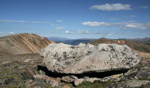
Yet somebody named this mountain, and there it stands. The views are the typically spectacular scenes one expects of most Colorado thirteeners, and it is a gentle summit that won’t take much time or effort after a summit of Geneva or as a diversion from the CDT route across the high ridges here. The mountain also features some impressive rock outcrops and some of the prettiest mineral-laden rocks to be found anywhere in the vicinity—rocks I did not find elsewhere along my traverse of Sullivan, Geneva, and Landslide from Santa Fe Peak.

Route Information
One way to climb Landslide is via Sullivan Mountain and Geneva Peak from Santa Fe Peak (see Getting There). This route is approximately 4 miles round-trip and involves a total of about 1700’, and it is easy Class 2 that is only Class 2 because it is not along an established trail.
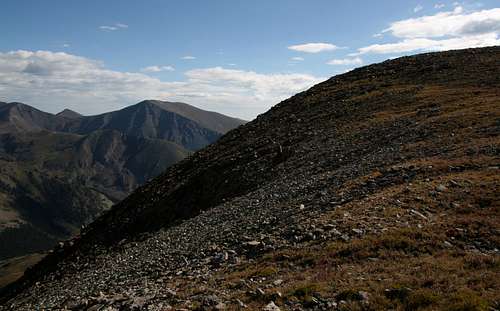
From Santa Fe Peak, descend to the saddle connecting it with Sullivan Mountain and then hike to Sullivan’s summit, gaining about 270’. Viewed from Santa Fe, Geneva seems to have a knife-edge leading to its top, but the view from Sullivan reveals that the ridge is not as exposed as it first appeared and has a trail following its right side. The ridge does drop steeply and dramatically on its left side, with many jagged pinnacles and outcrops breaking the ridge proper.
Drop to the saddle between Sullivan and Geneva and then ascend about 600’ to Geneva’s summit. There are many spectacular rock formations along the ridge (Class 2+), and you will miss most of them if you stick to the trail. Your call—the ridge is more exposed and windier but more exciting, and the trail is safer and more sheltered but less interesting.
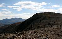
From Geneva’s summit, Landslide lies about 0.5 miles southeast. Descend about 150’ to the broad saddle between the peaks and then hike about 140’ up to Landslide’s summit.
Climbing Landslide this way requires negotiating the 4WD road up Santa Fe Peak. Some details about the road:
• The road to Santa Fe Peak is marked as a 4WD road for good reasons. It is very steep in places (climbing to over 13,000’), with tight switchbacks and some off-camber spots. I have made it up the road in 4-High before, but it is more comforting to use 4-Low in some places. Although the road is rocky in places, it is not too rugged for stock high-clearance vehicles. I do recommend using a vehicle with real 4WD, but skilled off-road drivers could probably make it up the road with just AWD.
Getting There
From U.S. 6 at the eastern end of Keystone, take the signed road to Montezuma. This road is easy to find if one is traveling eastbound, but there is no direct access to it for westbound travelers, who will have to watch for the road and then make a U-turn to get to it.
It is five miles to Montezuma, where the road turns to dirt. The road to Santa Fe Peak takes off to the left, but it is not signed. Look for a road heading uphill into the wooded slopes above the tiny town, or look for a telephone/power pole marked 5325 and turn left onto the road there.
It is 5.1 miles to where I parked my jeep and began hiking. When the road finally tops a plateau-like area near the base of Santa Fe Peak at about 4.5 miles (the peak is ahead and to your right), there is an intersection. TURN LEFT. The right fork seems to head straight for the peak, but it dead-ends shortly, though far enough away that you can’t see that from the intersection. The left fork eventually turns southeast and heads toward Santa Fe Peak, edging along the right (west) side of the summit. As it edges along the side of the summit, the road is narrow, rough, and, for a vehicle, exposed, and this section may unnerve some drivers. But if you continue on, the road will start descending steeply. Park in a small rocky area just off the left side of the road and about a hundred vertical feet above the saddle connecting the peak to Sullivan (see photo in this section-- right column).
DO NOT PARK ON THE ROAD. No matter where you decide to park, make sure you are off the road (and not on the tundra). This road is too narrow for people to be blocking it even a bit.

Red Tape and Camping
There are some primitive camping areas along the road to Montezuma. There are very few decent camping areas along the road to Santa Fe Peak, and many of them are either on posted private property or between 12,000 and 13,000 feet in altitude, where it’s not very comfortable for most people to sleep.
External Link
Contact White River National Forest for more information, including for the Santa Fe Peak Road. Phone number: 970-945-2521.