
|
|
Mountain/Rock |
|---|---|
|
|
36.27878°N / 51.06038°E |
|
|
Mountaineering |
|
|
Summer |
|
|
13773 ft / 4198 m |
|
|
Overview
Click for Introduction to Central Alborz Mountains.Click to see the Map of the Takhte Soleyman Massif.
Name Alert: For some reason this peak has been given at least three different names. These include: “Zarrin Kooh”, “Aband” and “ Maseh Chal”.This mountain should not be confused with another Zarrin Kooh that rises in the southeastern portion of the Central Alborz Mountains.
 Zarrin Kooh from the northwest
 Our Camp
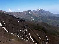 Zarrin Kooh from NW
Zarrin Kooh is the southern-most 4000 meter peak of the Takhte Soleyman Massif. From the northwest, Zarrin Kooh connects to the Varzakool (3958 m) and Siahleez Peaks (3975 m) and from the east, it connects to the 3890 m Zard Gooleh Peak. The southern slopes of Zarrin Kooh go down to a branch of the Shah Rood (Taleghan) Valley and its northern slopes drop down to the bottom of a branch of the Chalus Valley.
 Zarrin Kooh from Alaneh Sar Peak
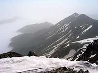
Zarrin Kooh sits on the boundary between the lush northern slopes and the barren southern slopes of the Alborz Mountains. Clouds from the Caspian Sea (to the north) often fill the Chalus Valley and its branches. While Caspian rain forests cover these northern slopes up to an elevation of 2300 m, the southern slopes remain forest free.
 Summit Summit |  Finding Drinking Water Finding Drinking Water | 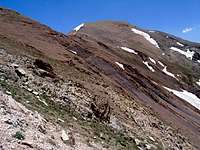 Summit Summit | 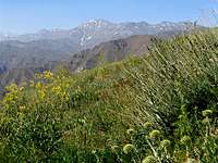 Southern Slopes Southern Slopes |
A large alpine bowl sits to the northwest of Zarrin Kooh at an elevation of 3400 to 3600 m. During the snow melt season, a few small lakes form at the bottom of this field at the base of the snow field that covers the bowl.
 Lakes Lakes |  Lakes Lakes |
Zarrin Kooh is usually climbed via its southern slopes. The starting point is the 2350 m village of Narian that sits in a branch of the Taleghan Valley. A 12 Km hike will take you to the summit. A descent route via the northern slopes to the village of Dalir has been described at this Farsi Site (click here).
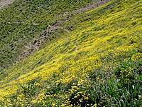 Flowers Flowers |  Summit Summit |  Summit Summit |
Views from the summit of Zarrin Kooh:
 Zard Gooleh Zard Gooleh | 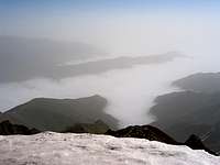 Branch of Chalus Valley Branch of Chalus Valley |  Avidar & Subpeak Avidar & Subpeak |  Varzakool Varzakool |
 Alam Kooh
Getting There
Directions to Narian VillageFrom the western parts of Tehran, Drive the Tehran-Qazvin Freeway 40 Km west to the town of Karaj, continue roughly another 60 Km to a village called Abyek. A little on the west side of Abyek, take the exit to “Ziyaran-Shahrak”. Drive this road 40 Km north to reach Shahrak (or Shahrake Taleghan). This town sits at the bottom of the Taleghan (Shah Rood) River Valley. Continue the road past Shahrak heading east 15 Km to reach the village of Jowestan. Here, right goes to the village of Gateh Deh and left to Narian. Take the left road and drive 8 Km to a split in the road. Left goes to the village of Parachan and right to Narian. Take the right road and cross the bridge then drive a few kilometers up a saddle and then down to reach the village of Narian.
Red Tape
No fees or permits required. Northwest face of Zarrin Kooh
Camping
Anywhere The impressive east face, by Nomad