
-
 19510 Hits
-
 82.48% Score
-
 15 Votes
|
|
Mountain/Rock |
|---|---|
|
|
44.79020°N / 107.8318°W |
|
|
Big Horn |
|
|
Hiking, Scrambling |
|
|
Summer, Fall |
|
|
10042 ft / 3061 m |
|
|
Overview
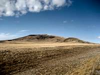 Bald Mountain from the east
Bald Mountain is the second-highest peak in the northern part of the Big Horn Range in Wyoming. Its rounded dome can be seen from great distances from the west in the Big Horn Basin, and it stands alone from the surrounding peaks, with all sides of the mountain offering hikers at least 800 feet of elevation gain. The plateau on top of Bald Mountain is large, measuring one mile long and ranging from 1/4 to 1/2 mile wide. The summit is found on the east end of the plateau, on a small area which gently rises up another 100 feet from the surrounding terrain.
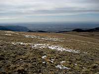 Summit view south
Getting There
From Lovell, Wyoming, take U.S. Highway 14A heading east for about 24 miles and turn right at the Bald Mountain Campground, which is clearly marked. To approach from Sheridan, Wyoming, follow Highway 14 to Burgess Junction, turn right on Highway 14A, and travel for 20 miles. Bald Mountain rises up just southeast of the campground. There is an unmaintained road that splits off to the left from the road running into the campground that is marked as closed to vehicle travel; park where the road is blocked off and continue on foot. I chose this route to avoid the forested areas on the north side of the mountain, figuring I'd have less chance of surprising a bear out in the open, but the mountain could be climbed in a similar and slightly shorter way from the east side. Bald Mountain from the north
After leaving your car, look for the place where the log fence bordering the campground meets the barbed wire fence that runs over to the trees. When I hiked this area in October 2008 the wire fence was disconnected from the posts and was on the ground, making it possible to walk through the fence at any point. If the fence is up, there should be a break in the fence where it joins the log one. Cross to the south side of the fence and turn slightly left to continue up the slopes of Bald Mountain.
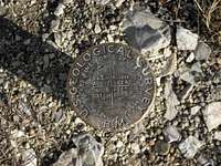

There is no trail, so make your way straight up the grass-covered slopes, being careful to avoid the holes in the uneven ground which make it very easy to roll an ankle, especially on the descent. Once you achieve the plateau, you will see the summit just less than a mile to the east. The summit has a USGS marker that lists the summit as just slightly less than the 10,042 feet listed on the topographic map. There is also a tall post at the top with a bird house attached to it.
Reaching the top of Bald Mountain from the campground is an easy Class 2 hike, and it takes around 2 hours to complete the 3.5 mile round trip.
Red Tape
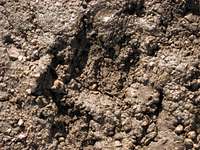 Bear track
Access to this area is very easy except during the winter and early spring, when Highway 14A is closed. This area has an abundance of wildlife, so be especially aware of moose, elk, black bears, and mountain lions when hiking in this area. There are no grizzlies in the Big Horns.
Camping
Places to camp in the Big Horns are numerous, with the majority of the range being open to dispersed camping. Camping is not allowed within 100 feet of lakes or streams, or within 1/4 mile of major roads. For complete rules and regulations, visit: http://www.fs.fed.us/r2/bighorn/recreation/camping/Bald Mountain Campground is located just off the highway on Road 130, which turns south off of 14A, and has fifteen camping spots and typical campground facilities.
External Links
The failed mining town of Bald Mountain City is located about 2 miles northeast of the mountain across the highway:http://www.ghosttowns.com/states/wy/baldmountaincity.html