
|
|
Mountain/Rock |
|---|---|
|
|
48.93987°N / 19.57729°E |
|
|
Hiking, Mountaineering, Skiing |
|
|
Spring, Summer, Fall, Winter |
|
|
6575 ft / 2004 m |
|
|
Overview
Derese is the third highest mountain in the Low Tatras, i.e. Nizke Tatry. Like Chopok, Derese is located in the main ridge, in the eastern part of the so called Dumbierske Tatry, named after the highest peak of the whole range: Dumbier /2043 m/. Derese is a popular hiking destination, especially from nearby Chopok which can be reached by cable car. Unlike Chopok there is no trail straight to the summit from the north. Hikers must visit sedlo Pol’ana or Chopok first and then traverse along the ridge to the summit. From the south the peak is much easier to climb- the slopes are covered by scree and grass.Ridges of Derese:
- east: main ridge of the Nizke Tatry which culminates in Chopok and further in Dumbier.
- west: main ridge of the Nizke Tatry with important peaks like Pol’ana /1890 m/ and Chabenec /1955 m/.
- south: a long ridge that culminates in Palenica /1654 m/ and Baba /1617 m/.
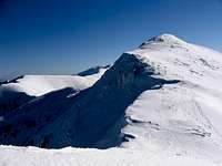
 Derese 2004 m
The north side is wild and steep: the face offers various opportunities of serious climbing especially in winter. The south side is much gentlier. A ski lift from the ski centre Chopok Juh ends almost at the top of Derese.
Derese rises above three big valleys: Demanovska Dolina in the north, Bystra Dolina in the south east and Vajskovska Dolina in the south west.
Demanovska Dolina is famous for its caves, especially the two that are accessible for tourists:
- Demanovska jaskyna slobody- Demanovska Cave of Liberty: Official site
- Demanovska l’adova jaskyna- Demanovska Ice Cave: Official site
Other important caves in the valley:
- Benikova
- Okno
- v Sokole
- v Malom Sokole
- Marosova
- Sucha
- Strieborne
- Stefanova
- Portalova
- Pusta
- v Kostolcach
 Derese
Another place worth visiting is Vrbicke Pleso- the only mountain lake located in the Nizke Tatry. Some info and pictures you can find here.
In Vajskovska Dolina there is a nice waterfall- 9 m high.
Derese is a fantastic viewpoint with great panoramas in all directions. The summit is marked with few cairns.
Routes
There are plenty of possibilities of reaching the top of Derese using marked trails. The main one - E8 European Walking Route is marked red and follows the main ridge of the Nizke Tatry. The shortest option from the south is to take the yellow marked path from Srdiecko, at Kosodrevina switched to the blue one and at Sedlo Prislop get back to yellow: 3 h total. From the north situation is a little bit more complicated: most of the hikers choose the loop /see below/. Demanovska Dolina Demanovska Dolina |
 From Dumbier From Dumbier |
 Bystra Dolina Bystra Dolina |
Two most common loops:
- From the north
From Vrbicke Pleso by the blue marked path through Lukova to the summit of Chopok: 2,5 h. Then turn right and follow the red marked path along the west ridge to the summit of Derese /2004 m/ and then continue to Sedlo Pol’ana /1837 m/ - 2 h. From here down to the parking lot next to Vrbicke Pleso by the yellow marked path: 2 h. 7 h total. - From the south
From Srdiecko take the yellow trail up to Kosodrevina and follow it further to the summit of Chopok /2,5 h/. Then turn left hiking along the ridge, summit Derese and continue to Sedlo Pol’ana /the same as from the north/. From there go further to the summit of Pol’ana /1890 m/ and then down to Krizske Sedlo /1775 m/ - 2,5 h. Then down by the blue trail to Kosodrevina 2h, and in 30 minutes by yellow marks to Stredisko.
The top
Derese has three summits that rises above the main ridge. The central - main summit is the highest: 2004 m. A lower summit called Predne Derese is located east from the main summit /in the direction of Chopok/. The second lower summit- Zadne Derese is located west.Below the summit of Chopok there is a chalet called Kamenna Chata pod Chopkom. It’s about 45 minutes of hiking along the ridge from the summit of Derese.
 Kamenna Chata and Derese
The official site of the hut contains plenty of important information: besides contact numbers for booking a place you will also find a webcam, info on current weather conditions and fine pictures and panoramas.
Adress:
Kamenná chata pod Chopkom
977 01 Brezno
Phone:
+421 48 617 00 39
E-Mail:
kamienka@kamennachata.sk
Like the nearby Chopok summit of Derese is considered one of the coldest and windiest places in Slovakia.
Skiing
Being located not far away from Chopok Derese became recognizable among skiers. Derese is a part of both ski centres on Chopok which are very popular among people from the surrounding countries like Poland, Hungary or Czech Republic.The Chopok skiing center is divided into two parts: north /Chopok sever/ and south /Chopok juh/.
Chopok sever
- ski slopes from 2000 m above sea level to 950 m
- one cable car
- four chair lifts
- 10 ski lifts
- over 20 km of ski trails
Some info here and here.
There is a ski lift that takes skiers into the Deressky Kotol to the altitude of 1655 m.
 Derese from the Chopok Sever ski centre
Chopok juh
- ski slopes from 2000 m above sea level to 1080 m
- two chair lifts
- four ski lifts
- over 8 km of ski trails
Some info here.
There is a ski lift that ends almost at the top of Derese.
Getting there
To get to the north side of Derese you have to reach Liptovsky Mikulas first. It’s located 50 km west of Poprad where an airport is located. From Liptovsky Mikulas by bus or by car into Demanovska Dolina.The south side is easily accessible from Banska Bystrica. In Zvolen - 20 km to the south - is a small airport. Banska Bystrica is located about 200 km north of Budapest and 250 km north-east of Bratislava. From Banska Bystrica drive north east to Podbrezova and then north to the Bystra or Vajskovska Dolina. You can also reach Bystra Dolina or Vajskovska Dolina from Poprad /airport/.
Accommodation and camping
 Zadne Derese
Besides Kamenna Chata pod Chopkom which is about 45 minutes away from the top of Derese there are two more huts in the surroundings:
Chata gen. M. R. Štefánika 1740 m. Official site.
Chata Ďurková pod Chabencom 1623 m. Some info.
In both: Demanovska and Bystra Dolina there are plenty of accommodation possibilities. From simple rooms to sophisticated and really expensive hotels. You can also find some hostels in Vajskovska Dolina /Krpacovo, Dolna Lehota/.
Campgrounds:
- Bystrina - Pavčina Lehota /Demänovská dolina/
- Tale /Bystra Dolina/
In the national park camping is forbidden.
Red tape
 From Chopok
Derese is located in the National Park of Nizke Tatry- NAPANT. Be sure that you are ok with the rules. All the restrictions you will find here.
For any other questions or doubts:
National Park Nizke Tatry Administration
Lazovná 10
974 01 Banská Bystrica
tel.: +421 48 413 0888, +421 48 413 0889
tel./fax: +421 48 413 0820
e-mail: napant@sopsr.sk
Emergency
 In the distance
Mountain rescue: HZS- Horska Zachranna Sluzba.
Emergency number: 18 300
Contact:
HZS Nízke Tatry - sever
Jasná, 032 51 Demänovská Dolina
tel.: 044/5591678, fax: 044/5591478, mobil: 0903624070
e-mail: ntsever@hzs.sk
HZS Nízke Tatry - juh
Tále, 977 01 Brezno
tel.: 048/6195326, fax: 048/6195327, mobil: 0903624078
e-mail: ntjuh@hzs.sk
The are the station of mountain rescuers in Kamenna Chata pod Chopkom.
When to climb
The best time to visit Derese is summer. Marked trails are open all year round with some exceptions /see the main page of the Nizke Tatry/. In winter be prepared for tons of snow and high avalanche danger.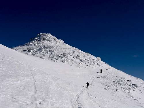 Derese
Mountain conditions:
Vey good weather forecast: here. This website shows also offer a few live webcams like this and that.
Another weather forecast: here.
Avalanche danger: here.