
-
 9343 Hits
-
 78.82% Score
-
 10 Votes
|
|
Mountain/Rock |
|---|---|
|
|
44.86020°N / 107.8853°W |
|
|
Big Horn |
|
|
Hiking |
|
|
Summer, Fall |
|
|
9469 ft / 2886 m |
|
|
Overview and Getting There
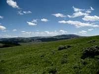 Looking towards Hunt and Bald Mountains
The aptly named Cone Mountain is a small hill in the northern Big Horns just southwest of Duncum Mountain. The gentle slopes leading to this summit feature beautiful fields of wildflowers, and this place is very popular with the herds of elk that roam the area. Easy access combined with distant views of Devil's Canyon to the west and the numerous small peaks surrounding Cone Mountain make this a worthwhile place to visit if you are looking for a quick summit hike.
From Lovell, Wyoming, take U.S. Highway 14A heading east for about 25.5 miles and turn left on Road 14, which is marked for Devils Canyon. To approach from Sheridan, Wyoming, follow Highway 14 to Burgess Junction, turn right on Highway 14A, and travel for about 18.5 miles. Stay on Road 14 for about 3 miles; if you hiking over the summit of Duncum Mountain on your way to Cone Mountain, turn right at the fork directing you to Sheep Mountain and follow the directions for the west summit of Duncum, but if you only want to hike Cone, continue on Road 14 for another 3 miles.
 Looking back up the ridge to Duncum Mountain
Hiking Information
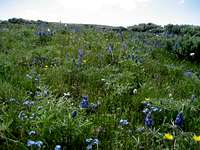 Wildflowers on Cone Mountain
 Elk on the ridge
When I visited Cone Mountain, I combined it with a trip to the summit of Duncum Mountain; this was a great walk and allows for a fun scramble down and up the south side of Duncum. To do this, simply walk up and over the west summit from the road and continue along the easy ridge to Cone, which is 1.25 miles away. This trip makes the elevation gains a little backwards, as the trip to Cone Mountain results in a net loss of 300 feet from where you park: 100 feet up to the Duncum summit, 600 feet down to the saddle, and 200 feet back up to reach the summit. Thus, most of the climbing is done on the return trip.
The combined Duncum/Cone trip is just under 3 miles with a total of about 900 feet gained over the various ups and downs of the Class 1 hike.
The other option is to approach from below the peak via Road 14 as described above. Park where an obvious opening in the trees looks directly up at the mountain, and hike straight up from here. This shorter hike lacks the beauty of the traverse, but it gets the job done if you are in a hurry.
The direct approach to Cone Mountain gains 800 feet over 0.6 miles of walking straight uphill.
As is typical of pretty much every hill and mountaintop in the north Big Horns, there is a rock cairn on top. Also of note, there is a small corral on the ridge with a sign that says "Cone Mountain Range Study Plot Established 1961."
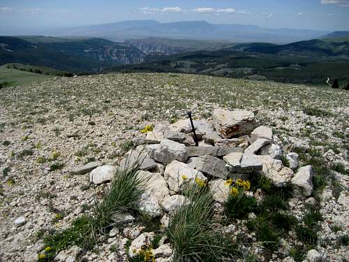 Looking over the summit cairn to Devil's Canyon