
-
 10344 Hits
-
 87.31% Score
-
 24 Votes
|
|
Mountain/Rock |
|---|---|
|
|
43.37656°N / 110.37793°W |
|
|
Hiking, Mountaineering |
|
|
Summer |
|
|
11180 ft / 3408 m |
|
|
 Summit
Overview
An ascent of Corner Peak is one of two things: a long, steep day climb that includes moderate-to-steep snow and Class 3/4 conditions on loose rock with respectable exposure; or a long, steep day hike. Or it can be both if you take one way up and another way down, enabling the climb of an additional peak (MacLeod Peak-- unofficially named but definitely real and worthy) and a grand tour of both Corner and MacLeod Peaks and some of the most beautiful but least-known wilderness in the Greater Yellowstone Ecosystem.
But note the common threads-- long, steep, day. You can, of course, backpack in to split the distance over two or even three days, but you will not enjoy lugging all that weight up the many very steep grades. So plan on this as a day outing, and give yourself plenty of time (more details in the Routes Overview section and the attached route pages) unless you plan to make Corner Peak one of several peaks in its immediate neighborhood to climb-- that neighborhood includes, in addition to MacLeod Peak, Open Door Mountain, Antoinette Peak, and Black Peak.
Something else about Corner Peak-- it does not look very impressive from any angle other than that along the traverse from MacLeod Peak (which is the more mountaineering way to climb the peak), but it has outstanding views of just about every significant peak in the Gros Ventre Range, and in the distance but not so far away as to be a squinting affair, the Teton Range and the Wyoming Range invite the eye, the camera, and the imagination.
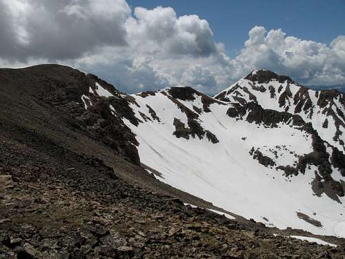
Chances are, people often misidentify Corner Peak when they are at the Swift Creek Trailhead (see next section). At the trailhead, one can see three high peaks directly west. The massive one on the right is Point 11,095, "Shoal Peak" (unofficial name). The one in the center is another unnamed peak, and it is a little over 11,000'; this peak is directly between Corner Peak and Shoal Peak. The peak on the left, the one with a triangular summit, is what seems to be Corner Peak, but it is actually MacLeod Peak; Corner Peak is not in view.
As far as I can tell, the reason Corner Peak is named so is that it sits at the very southeastern corner of the USGS Crystal Peak quadrangle. The quadrangle does not give an exact elevation for the peak, but an interpolated elevation based on the contours would be 11,180'. Although I got a GPS reading of as high as 11,232', the peak does not reach the 11,200' contour on the map, and I thus am using the 11,180' estimate.
MacLeod Peak, too, has an interpolated elevation of 11,180', but it is slightly lower than Corner Peak.
Pictures displayed on this page represent different views of and from Corner Peak; the attached route pages display pictures that show route conditions and views. The route-related photos are, however, included in this page's image gallery.
 Summit
Getting There
About 11 miles southeast of Hoback Junction, look for a signed road heading north into the Granite Creek Recreation Area. This gravel-and-dirt road, which can be a little rough but is still passable for most passenger vehicles, follows Granite Creek for 10 miles to Granite Hot Springs, a popular spa (admission fee required). Along the way there are spectacular views of Granite Creek and the Gros Ventre Range.
7.5 miles up the road, look for a spur that makes a bridged crossing of Granite Creek. Turn here and follow signs for 0.1 mi to a trailhead. Find a spur road (usually closed) that makes a bridged crossing of Swift Creek. Just across the bridge, a sign indicates the beginning of Swift Creek Trail.
Routes Overview
For maps, pictures, and more details, please see the attached route pages. What follows here is a very basic overview of two route options.
Via MacLeod Lake and Peak
This is a mountaineering route and involves a ridge traverse that goes at Class 3-4 on loose rock with significant exposure at times; it also holds the likelihood of several hundred feet of climbing moderate-to-steep snow (if you’re lucky-- if the snow has melted out, you are probably looking at a long talus slog).
One-way distance is about 6.5 miles, and elevation gain is about 4900’.
Hike the Swift Creek Trail and branch off to MacLeod Lake. From the lake, climb MacLeod Peak, the left-hand peak of the cirque and then traverse the ridge connecting MacLeod Peak and Corner Peak.
Via Swift Creek
This is a hiking route that follows a trail for about 5 miles and a ridgeline for about 2 miles. The altitude gain is about 4600’. Hike the Swift Creek Trail to a 10,378’ pass, and from there follow the ridgeline east and then south to Corner Peak.
 View from MacLeod Lake
Views of the Peak


Views from the Peak
 Antoinette Peak
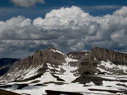 Cliffs west of Black Peak
 Black Peak
 Shoal Peak
 MacLeod Peak
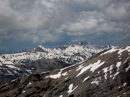 Pyramid Peak
Red Tape
No fees or permits. This is bear country, though, and habitat for both black and grizzly bears, so know your bear etiquette for both.
Camping
Granite Creek Campground is a mile up the road from the trailhead. It is a large campground with running water and flush toilets. Sites cannot be reserved. The camping fee was $10 per night in July 2009.
Dispersed camping is widely available, and backcountry camping is free (and no permit is needed).
More Information
Bridger-Teton National Forest