Mount Sneffels
Via Yankee Boy Basin Trailhead
Friday July 10, 2009
Following a full day of work on Thursday I was on the road out of Louisville at about 6:00PM and on my way to Route 285 via Route 93 to Route 6 to Route 470. The traffic was heavy but moving OK and things cleared-out pretty well once I got over Kenosha Pass and out across South Park. The weather was great and the drive smooth and uneventful as I made my way through Johnson Village and turned left (South) towards Salida. I then turned right (West) at Route 50 and continued over Monarch Pass and on through Gunnison and on to Montrose.
I was getting pretty tired and considered getting a room in Montrose but it was nearing midnight and a good many places appeared to be closed for the night. I drove through town and things seemed pretty much shut down as I turned left (South) on Route 550 were I stopped to fill-up at a King Soopers gas station. I then proceeded down 550 through Ridgeway and on to Ouray through town and around a short hairpin turn where I turned right unto FR361. This road soon turned to dirt but was well grated and the drive remained smooth for several miles where I came upon a large doe and her two small fawns right in the road. They didn’t scatter but kept prancing up the road directly in front of me in my headlights, this went on for about 100 yards before the doe and a fawn went right and the other fawn kept going up the road when it soon turned left and started bawling for it’s Mommy………never saw anything like this before, kinda neat.
The night was pretty black as the trees blocked the rising moon and the road soon turned a bit rougher but I made it the 7+ miles to the trailhead parking lot with the wooden outhouse. I saw a few cars on the way in but nobody around here. I was way beat and the moon was so bright it almost seemed like daylight as I finally turned-in in the back of my Sonoma about 1:15AM and was soon fast asleep.
My watch alarm sounded at 5:30AM and I was moving pretty slow preparing my breakfast of instant oatmeal, black coffee and a quart of Powerade. The wooden outhouse was pretty rank but suited my purpose and I saw one guy and then another soon pass by on there way up the trail (road). The weather was very mild and a thin layer of clouds kept temperatures comfortable as I finally readied myself and put my truck into 4 wheel drive and headed up the road hoping to reach the uppermost TH. I passed both guys and made it up to where a sign stated that the road was closed ahead. Here I parked heading down and chocked the back tires, as I readied my day pack both guys hiked past me again and I headed up the road behind them and around and up a couple of short switchbacks to where a large snow & ice drift blocked the entire road. I could have driven a little farther but no big gain in doing so; all three of us stopped at the trail registry, made our intros and signed in at 7:08AM.
![Yankee Boy Basin]()
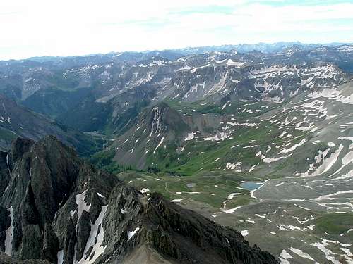
From here on me, Ben (26 yrs) and Ed (62 yrs) would hike together as a group. The wooden sign showed Mt Sneffels at 1.2 miles and Blue Lakes Pass as 1.0 mile, we proceeded up into the Yankee Boy Basin on a well traveled trail with a moderate rate of climb and beared right at the fork to begin the climb up a series of short switchbacks on the way up to Mt Sneffels. The surrounding peaks were spectacular and most still had a good amount of snow as we progressed higher and steeper to where we paused and could now see the snow laden ridge directly above with a loose, steep, scree-filled portion right below it. As we proceeded we found it a far better passage just simply scrambling up the rocky sections and avoiding the scree all together. Care had to be taken and being on all fours up the somewhat loose rock talus was the only way to keep from turning an ankle or worse. Progress was slow but steady and every step was up until we finally made the snow corniced ridge.
![Mt Sneffels Trail Route]()
Once on the ridge the gully leading to the summit appears up on the left and walking on the snow/ice ridge wasn’t a good option; Ben went to the right of the snow and Ed & I went to the left to where we soon did a short crossover on the snow and met up with Ben again. Here we now all continued the talus scrambling approach up the gully and made good progress to where the gully narrows and here is where the ice hard snows covered the entire gully up all the way to the visible “V-notch” high up on the left. I proceeded to try and kick step into the snow but it was simply too hard and I soon retreated back to the solid rock as a slip and fall here would have resulted in some really bad news. We re-grouped and since I was the only one who had brought my crampons and ice axe it was decided that Ben & Ed would scramble up and over left of the snowy gully and find a passage up to the summit. I, in turn would don my crampons, helmet, with ice axe and proceed up to the “V-notch” over the snow/ice filled gully.
We bid our a dues and as I was getting my crampons on I could hear Ben & Ed speaking as they went finding their route over solid rock. After some minor crampon adjustments I was on my way up the gully and after about 130 yards I reached the “V-notch”. Here I removed my crampons and pressed-on through the very narrow “V-notch” and passed through right as Ben & Ed had passed just before me. I soon caught-up after making a wrong turn and a class 4 move while bonking my helmeted head against an overhang to gain the short approach as we all reached the summit together right at 8:58AM.
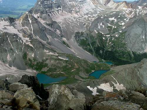
The clouds overhead and a soft breeze from the West had kept things cool and the weather was ideal for this endeavor, we all removed our packs and took a long rest while taking in some snacks. The views were awesome and many other distant 14’ers were visible as well as Telluride ski slopes and countless other snowy peaks as far as you could see. The Blues Lakes far below looked like topaz opals and the photo opportunities were endless as we took each others photos and enjoyed this tiny summit all to ourselves for a good 15 minutes before taking in some more food and drink and starting back down.
![Wilson Massif and Telluride Ski Area]()
![Blues Lakes]()
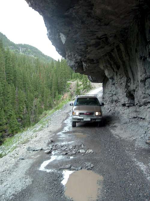
I decided to do the scramble, rock route versus down climbing on the snow-filled gully and the three of us found the best possible passage back down and although quite steep we managed a good descent and kept things safe by avoiding a couple of rather sheer sections and taking our time. It wasn’t long before we crossed-over left and found ourselves back in the gully well below the snowed section and met a young couple commiserating the fact that they didn’t have crampons for the snowy gully above and that this was their second attempt after being turned-away by the same issues a couple weeks before. Ben assured them that the summit could be gained regardless as they continued up and us down. We met several other groups coming up as we went down and the rocky talus sections were rather tough on the knees and we were all relieved to get back down to the more moderate switchbacks and back to the road. We signed out at the registry and got back to my truck at 11:00AM. Ed proceeded to hike back down to his car and I gave Ben a ride back to his with many jeeps and ATV’s now on the road and a certain degree of “gridlock” occurred in a couple spots. The “C-cut” road section was quite fascinating as I haven’t seen anything like this before either.
![C-cut Rock Road]()
Sooo……….following a failed attempt at Kit Carson 3 weeks before due to poor snow conditions; My first summit of 2009, my 43rd 14’er and another beautiful day in Colorado…………..Sweet!
Comments
No comments posted yet.