To the SW Ridge!
After acclimatizing on Yale the previous day I drove into Ouray and settled down for the night. I twisted my ankle slightly on the descent of Yale, so stopping at a Target in Montrose I stocked up on some Icy/Hot patches as well as a cheap little ankle brace. It was my first time in Ouray, and I was suitably impressed with the town and its variety of little shops, restaurants, and bars. The saloon below the Western Motel served an immensely enjoyable chicken caesar salad. As I settled down for an early night’s rest I suddenly realized that I had not scouted out the SW ridge of Sneffels at all. This would be important, as this was my intended route the next morning, so I turned my computer back on and spent the next hour browsing TR’s on 14ers and summitpost and fell asleep with a vague idea of what I had in store for me tomorrow.
I woke up and left the motel slightly later than intended and headed out of town and onto the Yankee Boy Basin Road. It was pleasant going for the first two miles, but the road got pretty rough starting around the shelf section. I managed to steer my Camry to the recommended passenger car spot 6.9 miles down the road. I made it, but it wasn’t fun, and I’m sure my poor Camry didn’t enjoy all the ruts, bumps, rocks, and bruises on this so-called 2WD road. The drive took longer than I had anticipated, and the sun was already up by the time I was packed up and started walking up the rest of the road.
![along the Yankee Boy Basin Rd]() Morning in the San Juans Morning in the San Juans |
|
|
|
![Sneffels Range]() San Juans San Juans |
Halfway between the first set of bathrooms and the end of the road I bumped into another hiker, bmratc from 14ers.com (If you’re reading this, sorry dude, but I forgot your name). We continued up the road at a decent pace, discussing mountains, out of all things. A few minutes below the end of the road, hit by a sudden burst of altitude or simple exhaustion, I needed to take a breather and told him he needn’t bother to wait for me, as he was headed up the Lavender Col anyhow. Bmratc raced up the road and I continued on my way a few minutes later.
![SW Ridge at dawn]() the SW Ridge the SW Ridge |
![Wilson Group from SW Ridge]() great view of the Wilsons from the Ridge great view of the Wilsons from the Ridge |
![Looking down to Blue Lakes pass]() back down towards Blue Lakes Pass back down towards Blue Lakes Pass |
![San Juans from SW Ridge]() Love the San Juans! Love the San Juans! |
The road flattened out at the Basin and the trail gained little elevation as it entered the talus fields below Sneffels’ southern slopes. Soon the junction for the Lavender Col appeared to the right; I continued straight, towards Blue Lakes Pass. The trail meanders around a few hills before taking a few switchbacks up to the pass. It seemed high above the Basin when I was still traversing the talus, but I regained a decent pace for myself and made it up in less time than I anticipated. A couple hikers were below me on the trail, but looking at their pace and equipment I didn’t think they were planning on climbing the SW Ridge. Once you gain the pass the view to the northwest side of the Sneffels Range is breathtaking, especially in the clear morning sun. The lakes themselves seem right below you, and you can see the trail heading down towards them. They would have posed at that moment a tempting destination had I not a summit to gain.
![Trail up to Blue Lakes Pass]() trail to Blue Lakes Pass trail to Blue Lakes Pass |
![Lavender Col from near Blue Lakes Pass]() Lavender Col from Blue Lakes Pass trail Lavender Col from Blue Lakes Pass trail |
![Approaching Blue Lakes Pass]() approaching Blue Lakes Pass approaching Blue Lakes Pass |
![Other side of Blue Lakes Pass]() great views at Blue Lakes Pass great views at Blue Lakes Pass |
![Snow Traverse on SW Ridge]() a short snow traverse a short snow traverse |
![Snow on SW Ridge]() after the snow traverse after the snow traverse |
I turned towards my intended destination. About my level, maybe higher in the scree slope across the basin from me I saw a pretty large group heading up to the Col. Looking to my left I saw the fearsome pinnacles of Sneffels’ Southwest ridge and plenty of talus to climb before the really fun scrambling part near the top, out of view from my perspective. I headed up towards the ridge, staying to the left of the lowermost pinnacles. The trail soon disappeared, but surprisingly the talus was pretty stable, despite being settled at a steeper slope. A few hundred feet above the pass I had to traverse a short snow slope, about 30 feet or so. It wasn’t too steep, but there were some jagged rocks at its bottom, and lacking all proper equipment but trekking poles I crossed one slowly kicked step as a time, taking care not to slip. Safely across, I continued up the talus. The terrain got steeper, but all the rocks, mostly boulder sized, were surprisingly stable, and it made for very pleasant climbing.
Ahead I could see two jagged towers above me, forming two sides of a U. I stayed on the right, climbing towards the tower on that side. Here is where my knowledge of the route got a little hazy. I knew there was a gap on the right. According to the trip reports I had perused, you are supposed to locate the gap, downclimb about a hundred feet, and then locate your way up to a narrow gully to regain the ridge. The only problem was that some TR’s seem to indicate the gap was below the right tower, some above.
![Approaching Towers on SW Ridge]() looking up the SW Ridge looking up the SW Ridge |
![Solid talus on SW Ridge]() The two towers. I stuck to the extreme right, probably too right. The two towers. I stuck to the extreme right, probably too right. |
![Talus on the SW Ridge]() surprisingly solid talus! surprisingly solid talus! |
Running into Trouble
I soon found myself at what seemed like a gap that lead to a downclimb into an icy gully below. I wasn’t sure whether this was the proper route, so decided to mark it down in my memory as I continued to climb higher. The walls narrowed around me as I climbed into a gully whose narrow passage was blocked by a set of overhanging rocks (below left).
![Tougher Scrambling on SW Ridge]() some scrambling as I climbed towards the tower some scrambling as I climbed towards the tower |
![right side of the SW Ridge]() this is not the correct Gap. I thought it was this is not the correct Gap. I thought it was |
I traversed around them on some solid rock tothe right and continued up the ever steepening gully. Up until now the talus and rock had been very stable, but I soon found myself on some scree and loose dirt ledges reminiscent of the Elks.
Continuing up past that obstacle I found myself below another chimney very near the top of the right tower (I think). I climbed up to see what was on the other side of these rocks and see if I could locate the route. It seemed however, that from here my intended course cliffed out onto the same ice gully I had observed below.
![sketchier terrain higher on the SW Ridge]() steeper, looser terrain higher up steeper, looser terrain higher up |
![Blurry pic]() Climbed this chimney, seemed to cliff out, so I went back down Climbed this chimney, seemed to cliff out, so I went back down |
In reality, I think the proper gap was located to my left (west), at about the same elevation. This is my conclusion after viewing the new 14ers.com route description, unfortunately posted a week
after my attempt on it. Not knowing this, I concluded that the gap I had observed way below was the correct gap. I retreated down the steep chimney and traversed right across a rock rib so that I can reach the gully, and possibly the ridge beyond, a few hundred feet above what I incorrectly assumed to be the correct gap. I cliffed out and retreated.
![Sneffels SW Ridge]() Traversed this rock rib... Traversed this rock rib... |
![Lost on the SW Ridge]() ...only to cliff out on the East side of the ridge ...only to cliff out on the East side of the ridge |
Downclimbing again, I think my intent was to avoid the steep loose dirt section between me and the incorrect gap. In order to do this, I saw a side gully to my (descending) left (east) that seemed to allow easy access into the ice gully.
This side gully was deceiving. It turned out to be steeper and looser than the very path I had wanted to avoid, giving me what could have been a sample of what Roach calls the ball-bearing scree on downsloping ledges. Technically I probably wasn’t too sound either, trying a face-forward descent, hopping down from one isolated ledge/rock to another, with a clunky backpack behind me and trekking poles that were a nuisance by this point.
![downclimbing through a gap]() climbing down through a gap climbing down through a gap |
![Descending loose ledges]() a sketchy downclimb, steeper than it looks a sketchy downclimb, steeper than it looks |
The rocks were loose too. One step set off a few rocks which snowballed into a pretty large and loud rockslide. The sound of rock to rock contact lasted for awhile, and ended probably a thousand feet below somewhere down in the snow/ice gully. I called out rock, but it probably didn’t matter, since I doubted anyone else was as lost as I was today.
At a particularly steep section, I dropped my poles onto the ledge below to allow for a less clumsy descent. One pole slipped down further than I intended. Chasing that pole while continuing the downclimb, I found myself stranded on a small downsloping rock. A tricky move was required to get down to the next one, and while I was trying to get my bearings for that move, I felt my backpack behind me pushing me down, forcing me to the edge of the rock. I tried to do the same with my backpack as it did to the poles. I dropped it down to the next ledge. It dropped, and kept dropping…
Please stop please stop please stop please don’t go over the cliff please don’t go over the cliff…
Oh f##k.
My backpack, complete with wallet, ID, cell phone, and car keys, bounced rock to rock, ledge to ledge, over a small cliff, and, following the course of the rockslide I had set off earlier, out of sight and down into God-knows where in the ice gully. Well, at least I was traveling lighter now.
![Lost Backpack here]() lost my backpack around here
lost my backpack around hereAbandon Hope, all ye Bone-headed Climbers
Having no other choice I did my best to track the downward course of my backpack. The going
was easier now that I had lost the clunker on my back (I really need to practice the art of face-inward downclimbing). I traversed gently down the light cliffy area right above the ice gully. Without an ice axe I wanted to avoid the snow and the jagged rocks below it, and I was able to find dry scrambling on talus blocks, albeit looser than the ones I ascended on the other side of the ridge, on the right side of the gully. I looked around and above me to see if my backpack had been caught on one of the side ledges. No such luck, and no sight of it below.
I was beginning to panic now. With no money, identification, access to my car, access to friends and family, I had no clue where to even begin. I hoped that the local Ouray jail had a few extra cots, if only for a place to stay for the night. I dreaded the thought of hitching a ride back to Yankee Boy the next morning, walking up that dreaded 4WD road, and rummaging for hours through trail-less talus in an attempt to find my backpack, with no guaranteed chance of success. It was a bleak moment.
Lower, and talus began overtaking the snow/ice that dominated the upper gully. A yellow spot below! False alarm, for as I approached it I realized it was but a bright boulder. More hops down talus and ledges. I see a bottle of water. Further below, a Cliff Bar. I was on the right track. Soon it was in view. No need for panic about money, keys, or ID now, but forlornly I realized that I had descended too much to find the backpack. It was late in the day, about 10 AM. I did not want to reclimb all the elevation I had lost, through all that sketchy terrain, even though going up was probably easier than going down. I didn’t even know for sure what the correct route was. It was time to call it a day, and call the day a failed attempt.
![Traversing across Sneffels]() Traversing across Sneffels
Traversing across Sneffels
Now with a dusty backpack on my back I looked towards Yankee Boy Basin and the road, still a decent ways below me. I wanted nothing more than to be back in the comfort of my car. I picked my way across a dry spot between two snowfields. I traversed sideways across the mountain. The talus was solid again. The Lavender Col stared right at me. I saw a solitary climber, dressed in black, making his way up the tedious slope. He was no more than 100 ft above me in elevation, just further on the other side of the mountain. I evaluated my situation; I was already about a third of the way up the slope to the Col itself. I had seen plenty of people heading up the mountain. I saw no one heading down; surely they hadn’t already descended to the 4WD road by now!
![Rays of hope]() reclimb the Lavender? reclimb the Lavender? |
![Sneffels Route-finding]() down and back up. down and back up. |
Back up the Lavender, Forsake the SW
I made my decision to traverse around the mountain and take the most direct line between me and the standard route, across the talus. Soon, I found myself ascending the talus parallel to the rough trail to my left. It was the type of hard-packed Colorado loose dirt trail that haunted me in my worst night terrors. It would serve me better to stay on the talus.
I made my way up one step at a time. The other climber stayed steadily above me, always in sight until he disappeared on the rim of the Col. I reached the Col and bump into bmratc and another climber, both heading down (sorry, I am awful with names). Here, I learned some bad news; the scree gully between the Col and the V Notch was filled in with snow. They had ascended the snow; so had a large group of seven or nine people. All had made it. None enjoyed it. On the way back down they found a route around the other side of the ridge. Both were very helpful in pointing out to me detailed directions on how to gain the drier route, taking out their camera and showing it to me on the pictures they took of the route.
I thanked them, knowing with relief that I could avoid the snow. They descended down the Col, I went up the gully. I approached the snow which covered the upper 2/3rd’s of the gully. To the left was a strip of snow with joined up with the main snowfield through a side gully. They had told me to look for an opening in the rocks, on the left right before this side strip of snow. I found it.
![Gully after Lavender]() Looking for exit on the left Looking for exit on the left |
![left side of gully]() Opening in the rocks Opening in the rocks |
There was a large step involved to gain a rocky ledge about 4 ft above the gully. That wasn’t bad itself, but the hardest part was getting traction on my footing right below the step, as the ground right below the opening was wet, muddy, slippery, and steep from the snowmelt above. I was told to look for a cairn on top of a flat slab of rock after climbing up and into the opening. I saw this, and assumed I had nothing more to worry about. Another route-finding mistake.
I traversed right, towards the summit, to gain the crest of what is essentially the Southeast Ridge of Sneffels. I soon found myself climbing steep, narrow, class 4/5 ledges, but on solid and enjoyable rock. After gaining the ridge crest, I saw a climber’s trail, and I saw that it led to the cairn I had observed below. Had I looked to my left earlier I could have avoided all that precarious climbing. Oh well, another misstep, but none the worse I suppose.
![above the standard gully]() Off route again... Off route again... |
![down towards the gully]() ...while gaining SE Ridge ...while gaining SE Ridge |
Now, the homestretch to the summit. A climber’s trail, slightly below the crest of the SE Ridge to the west, led all the way there, along with a couple of cairns. This trail, listed in Roach’s book as a variation to the standard Lavender Route (he mentions specifically it avoids the snow!), was another hard-packed dirt/scree slog. Better to ascend the solid, almost sandstone like blocks of rock closer to the ridge crest. As I went up the large group I had heard about, and seen for myself from Blue Lakes Pass, was downclimbing carefully down the ridge. After some more climbing I rejoined the standard route right above the V-Notch. I was exhausted by now, the day having been quite the ordeal. The sky was darkening, but everyone I had talked to said they felt the clouds today were harmless fluff balls. Hopefully the weather would continue to hold up.
![SE Ridge]() solid scrambling on SE Ridge solid scrambling on SE Ridge |
![looking down the SE ridge]() looking down SE Ridge looking down SE Ridge |
![towards the summit of Sneffels]() almost there! almost there! |
Finally, summit. Tom, the climber I had observed moving up towards the Col, was already there. He was from Flagstaff (Hey, I lived there once!). We both enjoyed the views and chatted a little. Tom had done over 40 14ers already. Later in the week he was backpacking in and attempting Capitol with a friend. After that, North Maroon on Monday. I was considering that peak that day as well, so we talked about possibly meeting up. Then it was time to head down.
![East towards Uncompahgre]() East towards Uncompahgre East towards Uncompahgre |
![South to Yankee Boy Basin]() Yankee Boy Basin Yankee Boy Basin |
![West from Sneffels Summit]() West from summit West from summit |
![Sneffels summit shot]() exhausted exhausted |
Tom had gotten the same advice from the other climbers to avoid the snow, but he decided to start climbing up the SE ridge crest immediately after the Col. He planned on descending the same way too. We began descending but he was way too quick for me. Soon I spied the side trail and the cairn leading back into the gully. He was already below this. I yelled down I was going back to the gully, and we parted ways. I bumped several people on my way down who were still heading up. The clouds were dark and numerous now, but I suppose they were still fluffy. I did my best to point or describe the way to the SE ridge, and wished them the best of luck to the summit and down.
I met up again with the large group at the Col. It turns out they were all part of a family reunion, and most of them were from North Dakota (Hey, I lived there once!). Most of them slid down one step at a time, face out, on the scree/dirt trail leading down from the Col. A few more intrepid climbers descended on the talus to the side. I did the same and soon passed them on my way down. Tom was for all intents and purposes back in the Basin.
The rest of the day was uneventful. Thankfully for myself as well as the other climbers on the mountain, neither lightning nor rain surfaced that day, and the sun had reappeared by the time I found my way back on the 4WD road. I passed countless ATV’s, jeeps, and trucks on my long trudge down to my Camry; one sympathetic soul offered me some water (I told her I had plenty), but none offered what I really wanted most: a ride down. Of course, I could and would do no such thing as to beg or hitchhike, so the last few miles dragged on forever.
![Group from North Dakota]() ND group descending ND group descending |
![Gilpin Peak]() Gilpin Gilpin |
![cascade along the road]() Cascades Cascades |
![heading down the road]() sublime afternoon view sublime afternoon view |
Back in town I decided to spend another day in Ouray to rest, as well as reinvigorate my sore legs and one slightly twisted ankle at one of the nearby hot springs so that they would be in good shape for Handies and North Maroon in the coming week. It had been a harrowing day on the mountain, but not only was I alive, in one piece, and had my backpack along with my wallet, keys and phone, but had after all that, summitted! It was odd too, that many of the other climbers on the mountain just happened to be from places where I used to live. Odd coincidence? I had felt a sense of foreboding ever since driving up the rough road earlier in the morning, and more than once wondered whether I should turn back, even before I reached the Basin. Stuff to ponder over on the walk.
Another thought snuck into my head as I trudged my way back to the car. Had I given up after finding my backpack, I would have returned someday to reattempt the SW Ridge. But…having now summitted, I doubted that I would return to try that route, which is I’m sure one of the most enjoyable ways to gain a 14er. It was a shame, and I really wished, and still do to this day, that my route-finding abilities were better, or that I had done more meticulous research before attempting it. Writing this log more than a month later, it gnaws at me, especially now that I know how close I actually was to the correct gap and all the great scrambling that awaited me in vain. Oh well. I console myself with the fact that I had my share of scrambling and climbing on that mountain, just not on any established route. Maybe one day I
will return to retry the SW Ridge.
![Pinnacles of SW Ridge]() looking at my erros on the SW Ridge looking at my erros on the SW Ridge |
![SW Ridge]() Oh, the What Ifs! Oh, the What Ifs! |
Just as an addendum, to avoid the crowds at the communal swimming pool that is the Ouray hot springs, I drove up to the smaller joint near Ridgeway. I knew from hearsay on other trip reports in the San Juans that this was clothing optional, but expected that they would have the naked section closed off in the corner somewhere, with most of the hot springs available to us more modest folks. I fervently hoped so, knowing that nude anythings invariably attracted mostly old, fat, dudes. Nope, just the opposite. There was a small indoor pool for the modest, and the rest of the place was anything goes.
I paid my fee and walked through the place in a New England Patriots bathrobe, boxers, and gym shorts. The springs themselves were great and extremely therapeutic for my aching muscles. I tried to block the view to the rest of the bathers by focusing my eyes on a large hardcover book about the Crimean War. The book got slightly soaked, but did its job obstructing the unpleasantness. As I was leaving, I went to retrieve my bathrobe. A naked, hairy dude had passed out partially on top of it.
Ewwwwww
Comments
No comments posted yet.


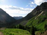 Morning in the San Juans

 San Juans
 the SW Ridge
 great view of the Wilsons from the Ridge
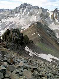 back down towards Blue Lakes Pass
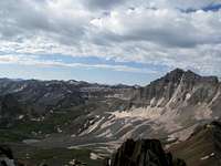 Love the San Juans!
 trail to Blue Lakes Pass
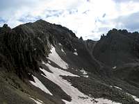 Lavender Col from Blue Lakes Pass trail
 approaching Blue Lakes Pass
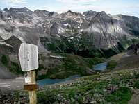 great views at Blue Lakes Pass
 a short snow traverse
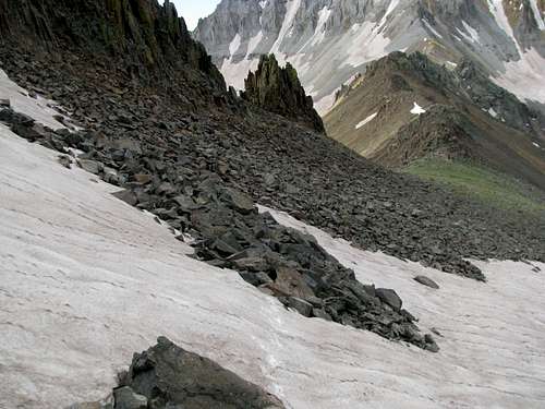 after the snow traverse
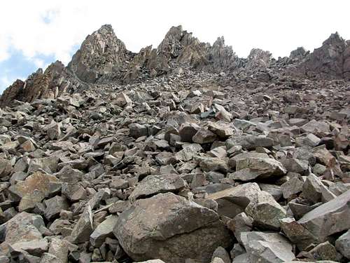 looking up the SW Ridge
 The two towers. I stuck to the extreme right, probably too right.
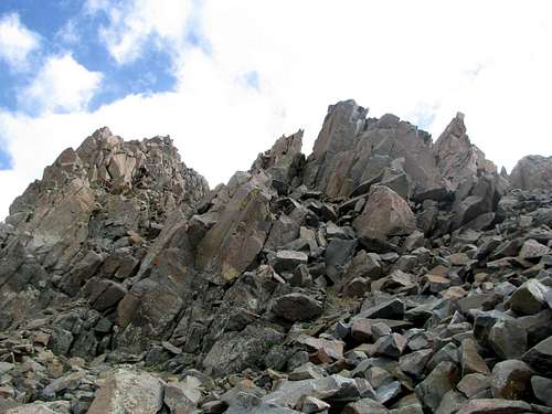 surprisingly solid talus!
 some scrambling as I climbed towards the tower
 this is not the correct Gap. I thought it was
 steeper, looser terrain higher up
 Climbed this chimney, seemed to cliff out, so I went back down
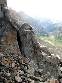 Traversed this rock rib...
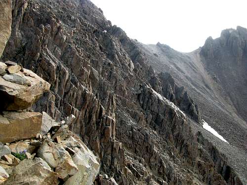 ...only to cliff out on the East side of the ridge
 climbing down through a gap
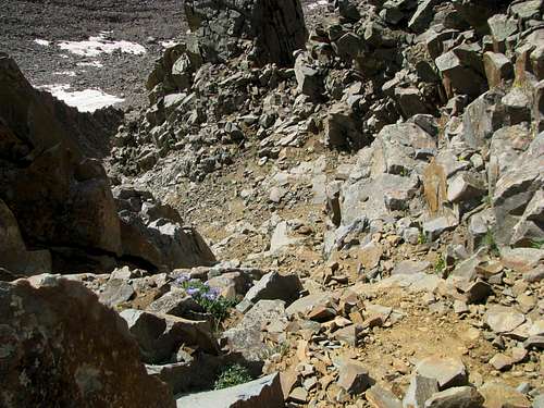 a sketchy downclimb, steeper than it looks
 reclimb the Lavender?
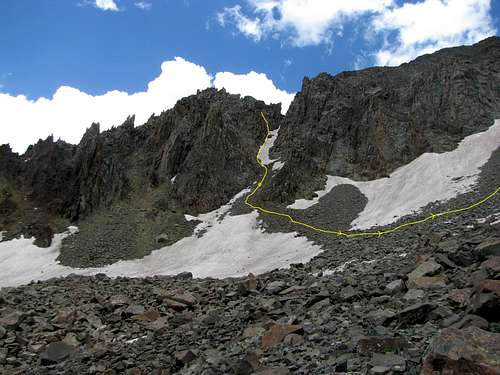 down and back up.
 Looking for exit on the left
 Opening in the rocks
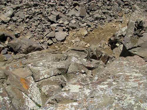 Off route again...
 ...while gaining SE Ridge
 solid scrambling on SE Ridge
 looking down SE Ridge
 almost there!
 East towards Uncompahgre
 Yankee Boy Basin
 West from summit
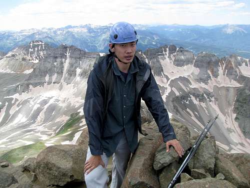 exhausted
 ND group descending
 Gilpin
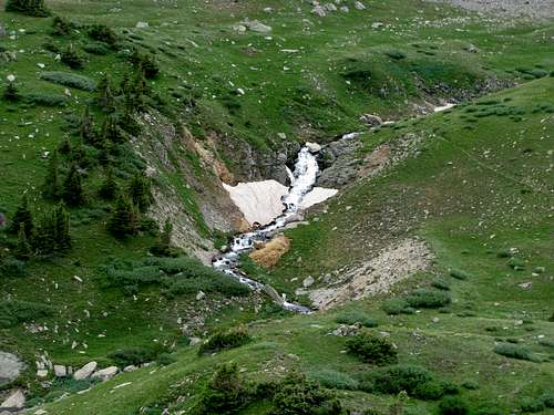 Cascades
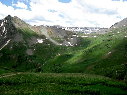 sublime afternoon view
 looking at my erros on the SW Ridge
 Oh, the What Ifs!