
-
 26682 Hits
-
 89.77% Score
-
 30 Votes
|
|
Mountain/Rock |
|---|---|
|
|
45.89160°N / 110.962°W |
|
|
Gallatin |
|
|
Hiking, Mountaineering |
|
|
Spring, Summer, Fall, Winter |
|
|
9449 ft / 2880 m |
|
|
Overview:
Layout designed for best viewing on a "1024 x 768" screen.
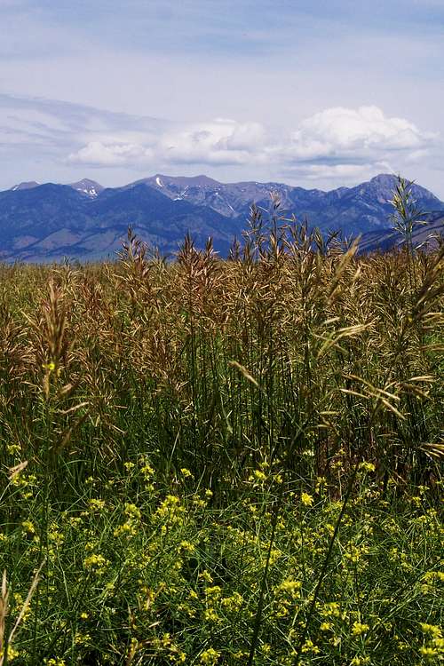 Naya Nuki Peak from the Gallatin Valley
Naya Nuki Peak is located in the Bridger Mountains of southwestern Montana. It is located approximately 22.5 miles North of Bozeman, Montana.
Naya Nuki can easily be identified from both the West and East sides of the Bridger Range. It is not the highest peak in this range nor is it all that rugged in appearance. There are no distinguishing cliffs on the west side or along the ridge top that would make this a “destination climb”.
Probably its only claim to fame is that it sits at the top of “THE GREAT ONE”, a couloir that is generally filled with snow year-round and therefore ski-able for the greater part of the summer. On any given day skiers are hauling their skis or snowboards to “THE GREAT ONE” for some QUICK TURNS in the summer snow. Approach from the East up "The Great One" is possible as well.
To see additional photos not seen on this page please follow linked colored text that is designated in all CAPITAL letters.
Sacagawea Peak is directly above the reverse comma in the photo to the left.
Naya Nuki is the next highest peak to the right of Sacagawea seen in the near center ridge line of this photograph of the Bridger Mountains.
Hardscrabble Peak is the peak seen in the far left of this photo.
Back Then and Now:
![The Bridger Mountains]() The Bridger Mountains
The Bridger Mountains
The Bridger Mountains were named in honor of James Bridger, a legendary mountain man, who explored the West from southwestern Montana to Utah during the early 1800’s. He is given credit for being one of the first non-natives to explore present day Yellowstone National Park. Imagine trying to explain geysers and sulfur laden air with a minimal education if any at all. Even an 18th century understanding of science certainly did not clearly understand about plate tectonics and the reasons for volcanic activity. Bridger measured the 600 mile Bozeman Trail which traveled from Laramie, Wyoming to Virginia City, Montana.
The Bridger Mountains are approximately 45 miles in length running from the south at the “M” near Bozeman to the 8,376 foot Blacktail Mountain on the north end of the range.
They are also home to an incredible endurance race. On the second Saturday of August runners pit themselves against the Bridger Mountains in what is known as “The Bridger Ridge Run”, which begins at the Fairy Lake Trailhead and ends at the “M”. Total distance covered is 19.65 or 20.55 miles depending on chosen finishing route and the total elevation gain is 6,800 feet (2,072 meters). Total elevation loss is 9,500 feet (2,895 meters). The fastest time belongs to Scott Creel who covered the distance in 3 hours 7 minutes and 36 seconds. The June 1 registration for the 2008 Ridge Run filled up in approximately 6.5 minutes.
The trail to Naya Nuki is part of the Ridge Run so don’t plan on climbing it on the second Saturday in August unless you want to share the trail with 350 runners.
![Forever Friends]() Sacagawea and Naya Nuki
Sacagawea and Naya Nuki![Naya Nuki - Shoshoni Girl Who Ran]() Jeff reading Naya Nuki, Shoshoni Girl Who Ran on the summit of Naya Nuki.
Jeff reading Naya Nuki, Shoshoni Girl Who Ran on the summit of Naya Nuki.
Sacagawea and Naya Nuki Peaks are approximately 6/10ths of a mile away from each other in the Bridger Mountains. Their names are forever joined in the history of southwest Montana. At 9,449 feet Naya Nuki is 216 feet shorter than Sacagewea which stands at 9,665 feet.
The local legend goes that Sacagawea had a childhood friend named Naya Nuki. They were kidnapped from their Shoshoni tribe and forced into labor by a hostile tribe. Kenneth Thomasma, wrote a fascinating children’s book called, Naya Nuki, Shoshoni Girl Who Ran. This fictional book based around Meriwether Lewis' account describes Naya Nuki’s experience as she escaped her captors and her 1,000 mile journey back to her people.
To honor this friendship two sister peaks in the Bridger Mountains in southwestern Montana were named Sacagawea and Naya Nuki. While standing on either summit one can look out over the plains on which these two childhood friends played.
Sacagawea played a crucial role during the Lewis and Clark Expedition in 1806. While traveling with Meriwether Lewis and William Clark’s Corps of Discovery she served as their guide up the Missouri River system and through the Rocky Mountains. During that expedition Sacagawea returned to the place where the three forks of the Missouri River (The Jefferson, Madison and Gallatin Rivers), join in the Gallatin Valley. This historic location is found near the modern town of Three Forks, Montana just off of Interstate 90. The Views:
![Enroute to Naya Nuki]() The Bridger Mountains
The Bridger Mountains
![Naya Nuki and Sacagawea]() Naya Nuki and Sacagawea Peaks
Naya Nuki and Sacagawea Peaks
![Sacagawea Peak]() Sacagawea from near the trail head
Sacagawea from near the trail head
![The Sacagawea-Hardscrabble Saddle]() Sacagawea-Hardscrabble Saddle
Sacagawea-Hardscrabble Saddle
![Naya Nuki Peak]() Naya Nuki from Sacagawea
Naya Nuki from Sacagawea
![South of Naya Nuki]() Looking south from Naya Nuki
Looking south from Naya Nuki
![Sacagawea from Naya Nuki]() Sacagawea from Naya Nuki
Sacagawea from Naya Nuki
Getting There:
![The Bridger Mountains]() Photo from near the "M" looking south to the Hyalite Mountains
Photo from near the "M" looking south to the Hyalite Mountains
The largest town by the Bridger Mountains is Bozeman, Montana. It is home to Montana State University, Home of the Fighting Bobcats. Bozeman is a quaint college town with numerous small pubs, shopping and great fishing on the three forks of the Missouri River and the Yellowstone River.
Bozeman is a destination for skiers with Bridger Bowl and Big Sky Resort less then one hour away. Local hunting and fishing guides host visitors from all over the world.
Gallatin Field serves as the airport for the Gallatin Valley. Bus services also travels directly through Bozeman on Interstate 90. Bozeman is located approximately 140 miles West of Billings, Montana and approximately 450 miles east of Spokane, Washington.
Once in Bozeman find a city map and look for a street named Rouse that turns north off of Main Street. Head north on Rouse which eventually turns into Bridger Canyon Drive (State Highway 86) past the “M” on the side hill. Stay on Bridger Canyon Road past Bridger Bowl until a fork in the road. At this fork stay on the pavement and follow the left fork past the Battle Ridge Campground.
Once past Battle Ridge Campground the road begins to go downhill and the road to FAIRY LAKE (ROAD # 74) is clearly marked. This is a potentially rough gravel road is 5 miles in length to the Fairy Lake Trailhead and has a lot of curves so proceed with caution. A high clearance vehicle would be helpful, but not necessary. There are numerous small side roads but just stay on the main road. The only difficulty as far as route navigation to the trailhead is at a fork that both roads seem well traveled. The correct route is not marked and is on the right the incorrect road is marked as a private road and ends at a gate in about ¾ of a mile. Mileage markers mark the route.
Upon arriving at the Fairy Lake Trailhead park in the area designated for the trailhead and leave the Fairy Lake parking for those who are recreating at the lake.
To reach the trailhead from the parking area walk West up the hill and look for the trailhead sign.
A route map can be found on this link: Naya Nuki Route Map. Please maximize this image for BEST viewing.Route Overview:
![Sacagawea-Hardscrabble Saddle]() Looking north over the Sacagawea-Hardscrabble Saddle
Looking north over the Sacagawea-Hardscrabble Saddle
The route to Naya Nuki is uncomplicated to say the least. A trail can be followed for the entire length of the climb. The most difficult part of the climb is working through the numerous switchbacks to attain the saddle between Sacagawea and Hardscrabble Peaks.
After reaching the saddle make sure to follow the correct trail. The photo on the left shows the CORRECT route which heads south along the TOP of the ridge and do not follow the lower trail that leads down to the western canyons below Sacagawea and Naya Nuki. The correct trail does not have signs and obviously leads up to the Southwest towards Sacagawea Peak. Also make sure to not follow the trail leading to the north to HARDSCRABBLE.
![Fairy Lake Trail Head Sign]() Sacagawea Trail Head Sign
Sacagawea Trail Head Sign
After working its way around the west base of Sacagawea the trail turns east and begins an earnest climb to the summit of Sacagawea. From the summit of Sacagawea the route travels along the ridgeline to just below the summit of Naya Nuki. Upon reaching the south side of Naya Nuki follow climber’s trails to the summit. It takes only 15 minutes to traverse the ridge between Sacagawea and Naya Nuki.
The “Great One” is located on the east side of the summit. Local Flora:
![Twinpod or Physaria]() Twinpod or "Physaria"
Twinpod or "Physaria"![Mountain Douglasia]() Mountain Douglasia
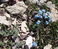
Mountain Douglasia![Alpine Forget-Me-Nots]() Alpine Forget-Me-Not
Alpine Forget-Me-Not
![Arrowleaf Balsamroot]() Arrowleaf Balsamroot
Arrowleaf Balsamroot![Rocky Mountain Phlox]() Rocky Mountain Phlox
Rocky Mountain Phlox![Tapered Leaved Beardtongue]() Tapered Leaved Beardtongue
Tapered Leaved Beardtongue
Red Tape:
Differing Views of the Bridger Mountains


The entire route is located in the Gallatin National Forest. Off trail travel is prohibited with signs along the route that clearly state to “Stay on the Trail”. There is a lot of fragile vegetation that could be trampled if this request is not honored. “Pack It In, Pack It Out” is also a mandatory rule. For other information please visit the Gallatin National Forest. Camping and Weather:
![Fairy Lake]() Fairy Lake and Campground
Fairy Lake and Campground
The Gallatin National Forest maintains a campground at Fairy Lake which is open from July to mid-September. The campground has 9 sites with handicap accessible toilets, picnic tables, fire rings, fishing access and fresh water.
There is also camping available at Battle Ridge Campground.
For more information and to reserve a campsite please visit the above links.
For local weather in the Bozeman area please visit: Bozeman Weather.Equipment:
No special equipment besides sturdy hiking boots and water are needed for this climb if it is done during the summer and early fall. If a trip is planned any other time of the year plan on dealing with a lot of snow and plan to bring avalanche gear as well as the usual snow equipment such as snow shoes and/or skis.External Links:
Gallatin National Forest
Back Then and Now:
 The Bridger Mountains
The Bridger Mountains were named in honor of James Bridger, a legendary mountain man, who explored the West from southwestern Montana to Utah during the early 1800’s. He is given credit for being one of the first non-natives to explore present day Yellowstone National Park. Imagine trying to explain geysers and sulfur laden air with a minimal education if any at all. Even an 18th century understanding of science certainly did not clearly understand about plate tectonics and the reasons for volcanic activity. Bridger measured the 600 mile Bozeman Trail which traveled from Laramie, Wyoming to Virginia City, Montana.
The Bridger Mountains are approximately 45 miles in length running from the south at the “M” near Bozeman to the 8,376 foot Blacktail Mountain on the north end of the range.
They are also home to an incredible endurance race. On the second Saturday of August runners pit themselves against the Bridger Mountains in what is known as “The Bridger Ridge Run”, which begins at the Fairy Lake Trailhead and ends at the “M”. Total distance covered is 19.65 or 20.55 miles depending on chosen finishing route and the total elevation gain is 6,800 feet (2,072 meters). Total elevation loss is 9,500 feet (2,895 meters). The fastest time belongs to Scott Creel who covered the distance in 3 hours 7 minutes and 36 seconds. The June 1 registration for the 2008 Ridge Run filled up in approximately 6.5 minutes.
The trail to Naya Nuki is part of the Ridge Run so don’t plan on climbing it on the second Saturday in August unless you want to share the trail with 350 runners.
![Forever Friends]() Sacagawea and Naya Nuki
Sacagawea and Naya Nuki![Naya Nuki - Shoshoni Girl Who Ran]() Jeff reading Naya Nuki, Shoshoni Girl Who Ran on the summit of Naya Nuki.
Jeff reading Naya Nuki, Shoshoni Girl Who Ran on the summit of Naya Nuki.
Sacagawea and Naya Nuki Peaks are approximately 6/10ths of a mile away from each other in the Bridger Mountains. Their names are forever joined in the history of southwest Montana. At 9,449 feet Naya Nuki is 216 feet shorter than Sacagewea which stands at 9,665 feet.
The local legend goes that Sacagawea had a childhood friend named Naya Nuki. They were kidnapped from their Shoshoni tribe and forced into labor by a hostile tribe. Kenneth Thomasma, wrote a fascinating children’s book called, Naya Nuki, Shoshoni Girl Who Ran. This fictional book based around Meriwether Lewis' account describes Naya Nuki’s experience as she escaped her captors and her 1,000 mile journey back to her people.
To honor this friendship two sister peaks in the Bridger Mountains in southwestern Montana were named Sacagawea and Naya Nuki. While standing on either summit one can look out over the plains on which these two childhood friends played.
Sacagawea played a crucial role during the Lewis and Clark Expedition in 1806. While traveling with Meriwether Lewis and William Clark’s Corps of Discovery she served as their guide up the Missouri River system and through the Rocky Mountains. During that expedition Sacagawea returned to the place where the three forks of the Missouri River (The Jefferson, Madison and Gallatin Rivers), join in the Gallatin Valley. This historic location is found near the modern town of Three Forks, Montana just off of Interstate 90. The Views:
![Enroute to Naya Nuki]() The Bridger Mountains
The Bridger Mountains
![Naya Nuki and Sacagawea]() Naya Nuki and Sacagawea Peaks
Naya Nuki and Sacagawea Peaks
![Sacagawea Peak]() Sacagawea from near the trail head
Sacagawea from near the trail head
![The Sacagawea-Hardscrabble Saddle]() Sacagawea-Hardscrabble Saddle
Sacagawea-Hardscrabble Saddle
![Naya Nuki Peak]() Naya Nuki from Sacagawea
Naya Nuki from Sacagawea
![South of Naya Nuki]() Looking south from Naya Nuki
Looking south from Naya Nuki
![Sacagawea from Naya Nuki]() Sacagawea from Naya Nuki
Sacagawea from Naya Nuki
Getting There:
![The Bridger Mountains]() Photo from near the "M" looking south to the Hyalite Mountains
Photo from near the "M" looking south to the Hyalite Mountains
The largest town by the Bridger Mountains is Bozeman, Montana. It is home to Montana State University, Home of the Fighting Bobcats. Bozeman is a quaint college town with numerous small pubs, shopping and great fishing on the three forks of the Missouri River and the Yellowstone River.
Bozeman is a destination for skiers with Bridger Bowl and Big Sky Resort less then one hour away. Local hunting and fishing guides host visitors from all over the world.
Gallatin Field serves as the airport for the Gallatin Valley. Bus services also travels directly through Bozeman on Interstate 90. Bozeman is located approximately 140 miles West of Billings, Montana and approximately 450 miles east of Spokane, Washington.
Once in Bozeman find a city map and look for a street named Rouse that turns north off of Main Street. Head north on Rouse which eventually turns into Bridger Canyon Drive (State Highway 86) past the “M” on the side hill. Stay on Bridger Canyon Road past Bridger Bowl until a fork in the road. At this fork stay on the pavement and follow the left fork past the Battle Ridge Campground.
Once past Battle Ridge Campground the road begins to go downhill and the road to FAIRY LAKE (ROAD # 74) is clearly marked. This is a potentially rough gravel road is 5 miles in length to the Fairy Lake Trailhead and has a lot of curves so proceed with caution. A high clearance vehicle would be helpful, but not necessary. There are numerous small side roads but just stay on the main road. The only difficulty as far as route navigation to the trailhead is at a fork that both roads seem well traveled. The correct route is not marked and is on the right the incorrect road is marked as a private road and ends at a gate in about ¾ of a mile. Mileage markers mark the route.
Upon arriving at the Fairy Lake Trailhead park in the area designated for the trailhead and leave the Fairy Lake parking for those who are recreating at the lake.
To reach the trailhead from the parking area walk West up the hill and look for the trailhead sign.
A route map can be found on this link: Naya Nuki Route Map. Please maximize this image for BEST viewing.Route Overview:
![Sacagawea-Hardscrabble Saddle]() Looking north over the Sacagawea-Hardscrabble Saddle
Looking north over the Sacagawea-Hardscrabble Saddle
The route to Naya Nuki is uncomplicated to say the least. A trail can be followed for the entire length of the climb. The most difficult part of the climb is working through the numerous switchbacks to attain the saddle between Sacagawea and Hardscrabble Peaks.
After reaching the saddle make sure to follow the correct trail. The photo on the left shows the CORRECT route which heads south along the TOP of the ridge and do not follow the lower trail that leads down to the western canyons below Sacagawea and Naya Nuki. The correct trail does not have signs and obviously leads up to the Southwest towards Sacagawea Peak. Also make sure to not follow the trail leading to the north to HARDSCRABBLE.
![Fairy Lake Trail Head Sign]() Sacagawea Trail Head Sign
Sacagawea Trail Head Sign
After working its way around the west base of Sacagawea the trail turns east and begins an earnest climb to the summit of Sacagawea. From the summit of Sacagawea the route travels along the ridgeline to just below the summit of Naya Nuki. Upon reaching the south side of Naya Nuki follow climber’s trails to the summit. It takes only 15 minutes to traverse the ridge between Sacagawea and Naya Nuki.
The “Great One” is located on the east side of the summit. Local Flora:
![Twinpod or Physaria]() Twinpod or "Physaria"
Twinpod or "Physaria"![Mountain Douglasia]() Mountain Douglasia
Mountain Douglasia![Alpine Forget-Me-Nots]() Alpine Forget-Me-Not
Alpine Forget-Me-Not
![Arrowleaf Balsamroot]() Arrowleaf Balsamroot
Arrowleaf Balsamroot![Rocky Mountain Phlox]() Rocky Mountain Phlox
Rocky Mountain Phlox![Tapered Leaved Beardtongue]() Tapered Leaved Beardtongue
Tapered Leaved Beardtongue
Red Tape:
Differing Views of the Bridger Mountains


The entire route is located in the Gallatin National Forest. Off trail travel is prohibited with signs along the route that clearly state to “Stay on the Trail”. There is a lot of fragile vegetation that could be trampled if this request is not honored. “Pack It In, Pack It Out” is also a mandatory rule. For other information please visit the Gallatin National Forest. Camping and Weather:
![Fairy Lake]() Fairy Lake and Campground
Fairy Lake and Campground
The Gallatin National Forest maintains a campground at Fairy Lake which is open from July to mid-September. The campground has 9 sites with handicap accessible toilets, picnic tables, fire rings, fishing access and fresh water.
There is also camping available at Battle Ridge Campground.
For more information and to reserve a campsite please visit the above links.
For local weather in the Bozeman area please visit: Bozeman Weather.Equipment:
No special equipment besides sturdy hiking boots and water are needed for this climb if it is done during the summer and early fall. If a trip is planned any other time of the year plan on dealing with a lot of snow and plan to bring avalanche gear as well as the usual snow equipment such as snow shoes and/or skis.External Links:
Gallatin National Forest
 Sacagawea and Naya Nuki
 Jeff reading Naya Nuki, Shoshoni Girl Who Ran on the summit of Naya Nuki.
 The Bridger Mountains
 Naya Nuki and Sacagawea Peaks
![Sacagawea Peak]() Sacagawea from near the trail head
Sacagawea from near the trail head
![The Sacagawea-Hardscrabble Saddle]() Sacagawea-Hardscrabble Saddle
Sacagawea-Hardscrabble Saddle
![Naya Nuki Peak]() Naya Nuki from Sacagawea
Naya Nuki from Sacagawea
![South of Naya Nuki]() Looking south from Naya Nuki
Looking south from Naya Nuki
![Sacagawea from Naya Nuki]() Sacagawea from Naya Nuki
Sacagawea from Naya Nuki
 Sacagawea from near the trail head
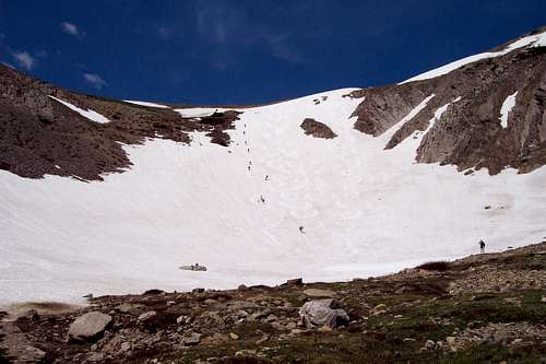 Sacagawea-Hardscrabble Saddle
![Naya Nuki Peak]() Naya Nuki from Sacagawea
Naya Nuki from Sacagawea
![South of Naya Nuki]() Looking south from Naya Nuki
Looking south from Naya Nuki
![Sacagawea from Naya Nuki]() Sacagawea from Naya Nuki
Sacagawea from Naya Nuki
 Naya Nuki from Sacagawea
 Looking south from Naya Nuki
![Sacagawea from Naya Nuki]() Sacagawea from Naya Nuki
Sacagawea from Naya Nuki
 Sacagawea from Naya Nuki
 Photo from near the "M" looking south to the Hyalite Mountains
 Looking north over the Sacagawea-Hardscrabble Saddle
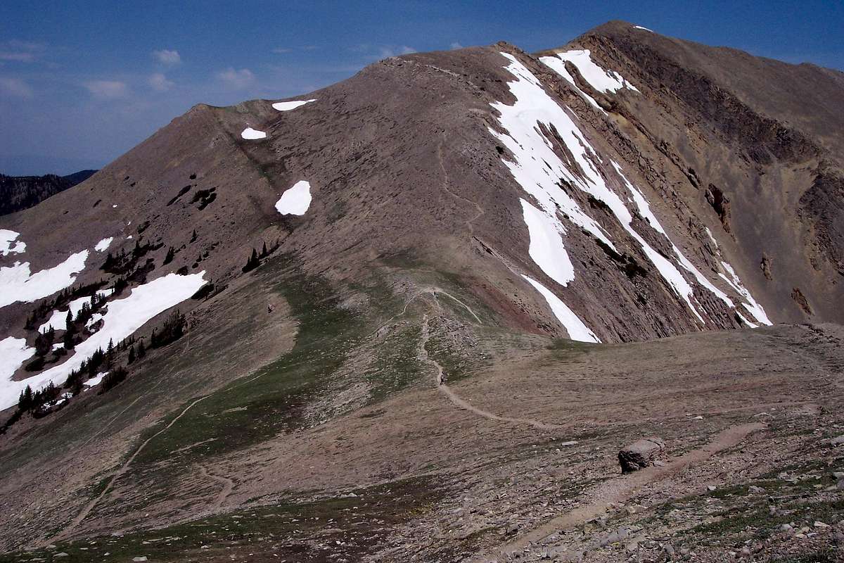
 Sacagawea Trail Head Sign
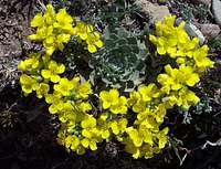 Twinpod or "Physaria" Twinpod or "Physaria" |
 Mountain Douglasia Mountain Douglasia |
 Alpine Forget-Me-Not Alpine Forget-Me-Not |
 Arrowleaf Balsamroot Arrowleaf Balsamroot |
 Rocky Mountain Phlox Rocky Mountain Phlox |
 Tapered Leaved Beardtongue Tapered Leaved Beardtongue |
 |
 |
|---|
 Fairy Lake and Campground