
|
|
Route |
|---|---|
|
|
37.09810°N / 118.5167°W |
|
|
Mountaineering, Ice Climbing |
|
|
Spring, Summer, Fall, Winter |
|
|
A long day |
|
|
Snow/Ice Class 4 |
|
|
Approach
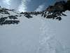
 Approach to the Thunderbolt glacier from Sam Mack Meadow
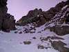
Begin at the trailhead at Glacier Lodge and follow the North Fork of Big Pine Creek trail. Follow the drainage to the Big Pine Lakes. After you pass 3rd Lake, continue on to Sam Mack Meadow. On Sam Mack Meadow, do NOT follow the signed Glacier trail that goes to the left from Sam Mack Meadow, continue south to the end of the box canyon. Climb the wall at the head of the canyon to the crest of the current terminal moraine for the Palisade Glacier. I found the best option to go up the "steepish" gully on climber's right (portions covered with snow all year) and follow the weakness to the glacier. Camping spots and running water can be found along the way. I highly recommend going as far as possible (i.e. as close to the glacier as possible) to cut down on the approach time next day. Once you reach the end of the moraine, you will see Thunderbolt Peak in front of you. Descend from the moraine to the glacier below and to the right (norteast) side of Thunderbolt.
Route Description
Beware - this route is named Northeast Couloir in Moynier's "Climbing High Sierra". The rock alternative is called Northeast Buttress in "Climbing CA 14'ers".

The North couloir is the wide couloir above large bergsrund (open later in the season) on the North Face of Thunderbolt. Whereas the "easiest" routes to the summit monolith are located on the west side, the Underhill Couloir and North Couloir are the two least difficult routes approachable from the east. The North Couloir specifically offers a safe descent route after climbing a more technical route on the east side. We descended this route when returning from NE Couloir in early October 2005.
The route is quite straightforward. The crux later in the season would be crossing the bergsrund - we were able to climb through, utilizing a snow bridge. In early October 2005 the route was mainly hard enjoyable neve, in late October 2006 it was neve with patches of water ice, and in March 2007 it was some neve but mostly powder snow - so be prepared for any conditions. Once above the berg, go up the left Y of the couloir and ultimately aiming for top at the climber's right of Lighting Rod. In late seasont the left Y of the couloir can be partially melted out leaving some scrambling over rocks or one can instead climb the right side of the Y and traverse over at top. The couloir is 1000 ft of approx. 30-40 degrees at most and takes about 1-1.5 hours to gain the upper northwest buttress.
Once you reach the northwest buttress, drop down approximately 50 feet on the west side. Traverse underneath the lightning rod by contouring on class 3/4 rock. Looking towards the notch between the lightning rod and the true summit is a obvious gulley - the end of the SW chute No. 1 route. Take this to the notch between the two summits (rememberig the south summit is the true summit) and climb the south summit monilith via a class 4 chimney to the summit block.
Essential Gear
Crampons, ice tools. Earlier in the season an ice axe may suffice but hard neve may be present on the bottom 200 ft of the couloir. If uncomfortable on steep snow, consider bringing rope and pickets. We were able to descend the route without any pro.Miscellaneous Info
the essential no-BS-added beta for the route is:- Cross the berg on the left. Hopefully, there is enough snow to cover the crevasse.
- Shoot for the notch north of the lightning rod.
- Descend to the west side ~50 feet and traverse to the chute that takes you to the notch between the true summit and the lightning rod. Spicy if there is a lot of snow...
- Ascend class 4/5 (depends on who you talk to. I think it is 4) to the summit block. This might be the crux?
- Ascend class 5.9 summit block.
If you have information about this route that doesn't pertain to any of the other sections, please add it here.
lavaka - Sep 5, 2006 5:54 am - Voted 9/10
North by NorthEastYou're sure this is what Moynier and Fiddler call the "NE" couloir? Because M & F rate it class 4-5 snow and ice, but I was up there in late August and, apart from getting past the bergschrund, it was low-angle snow, in accordance with what both Croft and Secor had led be to believe. Looking at the M & F guidebook, their photo does show the line going up the N. couloir (and it agrees with their verbal description), but perhaps they're mistaken. I haven't been on the left, NE couloir, but it sounds icy, and it would make sense if M & F really meant this one and simply made an error. Have you been on both the N and NE couloirs? Does the N. couloir really get icy? It simply doesn't seem steep enough.
PellucidWombat - Jul 20, 2010 7:09 pm - Voted 10/10
Re: North by NorthEastThe first time I climbed the couloir it had avalanched, scouring the snow down to ice, so it was a pure alpine/water ice climb from the bergschrund to the fork in the couloir. Much harder to climb than when I last did it as a snow climb!
kovarpa - Sep 13, 2006 5:41 am - Hasn't voted
responseI am 100% sure. Look at the picture in M&F High Sierra and they show the route up NE Couloir via the wide couloir right off the buttress that splits N and NE couloirs. This wide couloir (that I call North) DOES get ice, we encountered solid ice when descending it in mid-October 2005. When I went up this route in late July 2006, it was all snow and except for shrund it was quite easy. I agree that the 4-5 rating in M&F is overated, it is probably same or less steep than e.g. Dana Couloir. I think Secor has this right, the wide one is North Couloir, the narrow one, which is steeper and was solid ice, is NE. Also, both M&F and Secor that first party descended this route (the wide North Couloir) on the first climb of the peak and there is no way (IMHO) that they would descend the narrow NE couloir, unless they were smoking something :-)Makes sense?
PellucidWombat - Jul 20, 2010 7:14 pm - Voted 10/10
Take careto take the left fork before heading right! Following the main couloir to the right leaves several pitches worth of climbing before reaching the summit block. In later season the left fork melts out in sections, so look closely to see where to climb through rock bands to stay on course. If you do end up climbing too far to the right, stay to the left (east) of the ridge crest until you reach the final notch before the Lightning Rod before cutting to the right (west) side. Cutting over too early is a bad idea.
kovarpa - Jul 20, 2010 8:36 pm - Hasn't voted
Re: Take careyes, but you are still referring to left and right forks of the wide North Couloir. NE couloir is pretty narrow and does not have any forks, it is just one narrow steep gully.