
|
|
Route |
|---|---|
|
|
37.09810°N / 118.5167°W |
|
|
Mountaineering |
|
|
A long day |
|
|
5.8 (YDS) |
|
|
IV |
|
|
Overview
The proximity of these five 14ers, the solid granite, and the amazing views make this a worthy undertaking for any alpine ridge traverse aficionado.
History
Per Croft, the first ascent of Thunderbolt to North Palisade was made in June of 1934 by Norman Clyde, David Brower, and Hervey Voge. This was followed by Ken Davis and Jack Riegelhuth in August 1938, who traversed from Mount Winchelll to North Palisade in 13 hours. According to Porcella and Burns, the first known Thunderbolt to Sill traverse was completed by John Ohrenschall and John Mathias in 1958 over two days. This same pair made the first ascent of the V-notch two day later.
Getting There
Direction
The traditional way is to do this from Thunderbolt to Sill, but having done both directions I like Sill to Thunderbolt better. It has more technical climbing than the opposite direction if you start on the Swiss Arete and it makes the most sense if you start/end at Glacier Lodge.
To Shuttle or Not to Shuttle
The traverse may be approached from either the South Lake or Glacier Lodge trailheads. One option is set up a car shuttle starting at South Lake and ending at Glacier Lodge. The advantage is that you can haul ass up Bishop Pass, which is a relatively easy trail, and you don’t have to circumnavigate the ridge to the SW to get back to your car. The disadvantage is that you have to deal with the shuttle logistics on the way there and back. It’s ~53 miles between Bishop Pass and Glacier Lodge.
I have now done the whole traverse car-to-car from the Bishop Pass trailhead and Sill to Starlight (downclimbing Underhill Couloir) car-to-car from Glacier Lodge. The latter is by far the most direct way and is my preferred option over shuttling. If you're feeling extra perky you can start on Temple Crag and continue on to Galey, then Sill to T-bolt (highly recommended).
From South Lake
Google maps. See External Links & References for alternate driving directions/maps. From the trailhead follow the well-maintained trail to the crest of Bishop Pass (8 miles). The lake near the crest is a good place to top off your water. From the Pass leave the trail and head SW along the base of the Palisade Crest. SW Chute #1 starts just after Thunderbolt Pass.
From Glacier Lodge
Google maps. See External Links & References for alternate driving directions/maps. Note that at Glacier Lodge you have to park in the overnight backpackers’ lot (0.7 miles away from the TH) or pay $5 at the Lodge store unless you expect to daytrip. From the trailhead take the dirt road. At 0.25 miles you will reach the S Fork/N Fork junction. Continue on the N Fork trail past Third Lake to Sam Mack Meadow (~1 mile past the lake). This marks the start of the Thunderbolt eastern access routes (~8 miles) noted above. Top off your water in the stream if needed.
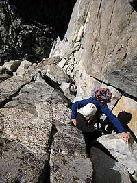
Route Description
Thunderbolt Peak (14,003 ft)
The most popular route up Thunderbolt, as described by Romain, Matthew, and Bob B, is the SW Chute #1 (Class 3 + 5.8 summit block), which is accessed via the S Lake trailhead. From Glacier Lodge the easiest route is the N Couloir (Class 4 + 5.8 summit block), as detailed by kovarpa. Alternatively, as noted by Misha the NW Ridge (5.5, 5.8 summit block), which begins at the saddle between Mount Winchell and Thunderbolt will increase your ridge travel quotient. Other ascent options are summarized by Dave K here.
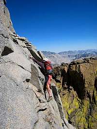
Starlight Peak (14,200 ft)
The traverse from Thunderbolt to Starlight goes at Class 4, as accurately described by bearbnz.
North Palisade (14,242 ft)
The traverse from Starlight is also rated Class 4, as summarized by Steve Larson. We stayed on the NW side of the ridge and encountered a wide gap with an overhanging boulder problem with some major exposure. The first time we rapped across the gap using existing rap slings. I went back to find a way to solo this section. There are several options for downclimbing into the notch on the SE side of the ridge (thanks to lavaka for the suggestion). I went down an exposed flake system on the SE side of the ridge. From the notch you can either climb a lie back (maybe one or two committing moves to reach a bomber foothold) or climb up a ramp on a mini version of Starlight to reach the ledge.
Polemonium Peak (14,080 ft)
Follow a reverse of the instructions (from Romain and Steve Larson) found here for the North Palisade Chimney route (5.2) from the summit to the U-notch. I have both rapped and downclimbed the chimney. The downclimb is easier than it appears from above. From the U-notch excellent instructions are detailed here (Class 4) by Bob B.
Mount Sill (14,153 ft)
Reverse the route description found here (thanks to guilty) for the West Ridge (Class 4-5).
Descent
Descent options are dictated by the location of your vehicle. If you are parked at S Lake, the easiest (in terms of technical difficulty) route it to drop off the SW side of Sill (Class 2-3) and follow the base of the (long) ridge back to Bishop Pass. If Glacier Lodge is your destination take either the L-shaped couloir or Glacier Notch routes. For the former, descend the W Ridge of Sill to the L-shaped couloir. From the colouir head down to Palisade Glacier, aiming for the right side of the glacial tarn. Having crampons (and an ice axe) will help if conditions are icy. From here head onto the benches. You will find use trails heading NW toward Sam Mack Lake. From Sam Mack Meadow cross the bridge and catch the N Fork of the Big Pine Creek Trail. For the latter drop down to the saddle between Sill and Galey (Glacier Notch) and skirt the W side of the NW ridge of Galey, joining up the the L-shaped couloir descent route on the benches above the tarn.
Essentials
Water
Opportunity to fill up at the stream in Sam Mack Meadow or the lake near the top of Bishop Pass.
Gear to Consider
- rope (a 50-60m makes things a lot easier/faster v. down climbing and it's helpful to protect the 5.8 moves required to gain the summit blocks of Thunderbolt and Starlight; also allows for a quick escape should the weather turn; could get by with a 30m)
- slings
- carabiners
- harness/rap device
- approach shoes with sticky rubber and/or rock shoes
- alpine rack
- crampons if planning to descend the couloir in icy conditions
- ice axe
- helmet (this is a busy area, plus there may be rockfall as the temps warm up and the ice melts)
- rap ring(s)
Backcountry Camping
If you are relatively fast, both on the trail and on technical terrain, you can probably day trip this. This means you should be comfortable soloing most, if not all of the route. Good camping is found around Sam Mack Meadow, on the benches below Palisade Glacier and in Palisade Basin. Note that water in the Palisade Glacier tarn can be extremely silty so consider bringing something to screen out the grit if you don’t want to trash your pricey water filter or drink treated sludge. A (reservable) backcountry permit is required from Inyo NF as you will be in the John Muir Wilderness.
External Links & References
Steve Eckert’s driving instructions to Big Pine/Glacier Lodge and South Lake
Croft, Peter. 2002. The Good, the Great, and the Awesome: The Top 40 High Sierra Rock Climbs. Maximus Press.
Porcella, Stephen F and Cameron M. Burns. 1998. Climbing California’s Fourteeners. The Mountaineers Press.
Topo Maps


PellucidWombat - Jul 23, 2010 5:29 pm - Hasn't voted
Rappel StationsOn the descent from Thunderbolt to the Underhill Couloir, you can rappel past the 5.6 section to the ledge that traverses to the easy slabs. I made an anchor at the top, which barely reaches the ledge with a 70m rope. If you start below the first steep section, there are some old solid pitons that could be reinforced for an anchor that could work with a 60m rope. The bottom is very steep, so take care not to rappel with a rope that is too short! Also, in the event that you want to bail down the Underhill Couloir, it has good and new rappel stations.
fossana - Jul 26, 2010 11:53 am - Hasn't voted
Re: Rappel Stationsthanks, Mark. Good info. I'd like to do this in reverse sometime (Swiss Arete > Underhill).
PellucidWombat - Jul 26, 2010 2:47 pm - Hasn't voted
Re: Rappel Stationsmy pleasure. It's always nice to get updated first-hand information for 'little' details like these!
fossana - Sep 29, 2010 1:05 am - Hasn't voted
in reverse notesSoloed the route in reverse from the Swiss Arete to Underhill (not enough time to do T-bolt). Approach is more difficult than from S Lake but the Swiss Arete goes quickly. The notch between N Pal & Starlight wasn't too bad in the opposite direction. I dropped down into the chimney on the N Pal side then downclimbed a lieback crack to reach the bottom of the notch. Underhill is a fairly quick descent to the glacier, but full of silt & loose rock. Take care if you have a partner with you or there are other parties below. The trail from Galey Camp is challenging to follow in the dark. I ended up blindly bushwhacking down to the Third Lake inlet (shorter than going back to Sam Mack). Still undecided about whether C2C from S Lake or Glacier Lodge is harder. The difference is the bulk of the talus slog from S Lake is at the end while it's half/half for Glacier.
fossana - Jul 23, 2013 1:13 am - Hasn't voted
Re: in reverse notesAs noted above my preferred approach/direction is now Glacier Lodge to the Swiss Arete to T-bolt. Last summer I linked this up with Temple and Galey, which was amazing (minus some of the chossy bits on Galey) and great training for the big Sierra traverses IMO.
caysedave - May 9, 2015 3:04 am - Hasn't voted
Re: in reverse notesAwesome TR and beta. Curious about the Temple/Galey start. How did you go up Temple...NE gulley/face (Mend col)?
fossana - May 9, 2015 9:30 am - Hasn't voted
Re: in reverse notesFor soloing I prefer Moon Goddess over Venusian; that's how I did the full Temple to Tbolt link-up a few years back. I have also done Sun Ribbon to Sill with a partner, but we roped up for the crux pitch. I posted some beta on MP.
caysedave - May 10, 2015 8:53 pm - Hasn't voted
Re: in reverse notesThank you!
spencerclimbs - May 11, 2015 7:19 pm - Hasn't voted
Re: in reverse notesI'm thinking about doing this as a solo as a last training effort before heading down to Peru. If I did glacier lodge to glacier lodge about how long to you reckon that would take assuming I'm going fast and light? And good recos for other beta/maps? Thanks in advance!
fossana - May 11, 2015 7:56 pm - Hasn't voted
Re: in reverse notesThat's a hard question to answer b/c it's dependent on a lot of things including route finding, comfort with exposure, fitness, acclimatization and conditions. The fastest way to do that direction is the Swiss Arete to Tbolt then down Underhill, which could be even more sketchy than usual with the recent freeze/thaw cycles. Be careful. The fastest I've done the climbing part (that I know of) was 7 hrs from the base of the Swiss Arete to the base of Underhill, but that: 1) was after I'd also done Temple and Galey; and 2) included time to help some less experienced guys routefind from N Pal to Underhill. If I had to take a wild guess I would say plan on 18-20 hours C2C for your first time. The Swiss Arete goes super fast (1 hr or less if you're soloing). The ridgeline is fairly convoluted so I don't really have any detailed beta to point to, unfortunately. I have a few more photos on my TR. Have fun!
Elijah - Dec 6, 2021 7:54 am - Hasn't voted
GPX trackHi there, anyone have or know of a gpx track for the traverse from thunderbolt to sill? Thanks.
Greenman - Jul 17, 2022 9:52 pm - Hasn't voted
A thorough trip report: "Thunderbolt to Sill Traverse 2016"There is a very thorough trip report named "Thunderbolt to Sill Traverse 2016" which unfortunately isn't listed on the trip reports for this page.