
|
|
Route |
|---|---|
|
|
39.07140°N / 106.95°W |
|
|
Technical/Scramble |
|
|
A long day |
|
|
Class 4 |
|
|
Standard Approach
Northeast Ridge Route-6 miles round trip & 4,428-ft
First, Pyramid is a very complex mountain. If you talk to 5 people about the route they took you would most likely get 5 different answers. I will describe to the best of my ability our route, which was probably not the easiest, but it sure was fun. When you get to the climbing part be aware that we went up a more difficult but solid route and we descended an easier more loose route, which I believe to be the “new” standard route on Pyramid.
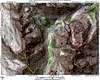
Starting at Maroon Lake TH (9,580-ft) follow the wide “West Maroon Pack Trail” as it gradually climbs the Aspen laden benches above Maroon Lake. After about 1.3 miles the trail levels out somewhat into a treeless area littered with rocks and grass. After studying your topo you will be looking for a way to get into huge amphitheater below Pyramid’s north face. To the left, locate the towering rock pinnacle shown here, the standard approach goes up to the left of this pinnacle. An alternate approach goes to the right of the pinnacle, which I will talk about later. After viewing your approach, the next objective is to locate the elusive climber’s trail on the left that will get you to the northern flanks of Pyramid and up into the boulder field below Pyramid’s north face. This trail has a serious reputation for being difficult to locate, especially in the dark when you should be trying to find it. Sometimes the trail is cairned and sometimes its not. Don’t be surprised if you can’t find it, it’s about a quarter of a mile before you reach Crater Lake. If you can’t find it don’t waste too much time because you know your objective is to the left of the large pinnacle-so just go for it.
If you find the trail follow it as it starts to climb the northern flanks of Pyramid. This trail is very steep and weaves in and out of the trees. Think of climbing a ladder for about 1,300-ft. This trail will get you to the beginning of the massive boulder field within the amphitheatre under Pyramid’s north face. Stay to the right and you will find a faint but usable trail that ascends up through the boulder field. From here you can marvel at how tiny you feel within the greatness of this huge cirque. When you arrive at the base of the north face of Pyramid (12,000-ft) locate the 13,000-ft saddle up to your left and then find the steep dirt gully that will get you there. This gully is not technically difficult; it even has a nice trail all the way up to the 13,000-ft saddle. I’m not sure it’s a gully but once again this section is steep, think of climbing another ladder for another 1000-ft.
 |  |  |  |  |
Approach Variation to Boulder Field
After locating the high rock pinnacle on Pyramid’s northern flanks, ascend loose dirt to the right of the pinnacle. This is not the standard route but the nice thing about it is that it drops you off about a quarter mile up into the boulder field. Remember that the boulder field is tedious to say the least, and we looked at this route finding mishap to be advantageous for it eliminated about 25% of the boulder field. One other note about this variation; when you get to the notch don’t be surprised how skinny the space is to get through. If you are a big guy you might not be able to fit through this slot.
Route Description
Once at the saddle you get an interesting view of the rest of your route. The last 400-ft to the summit looks impossible, but it does work out in the end. This is one of those spots that I’m sure many have decided to call it a day for the view is quite daunting, or exciting, depending how you look at it. Don’t expect any hiking for the last 1,000-ft, expect nonstop climbing on loose ledges and sandy vertical steps. Follow the ridge for a quarter mile to a nasty notch that prevents easy passage. O.K. From here the standard route has changed during the past few years. In both Dawson’s guide and Roach’s guide they both have you climb this headwall to get out of the notch. The new route, which is cairned, descends about 30-ft and traverses a skinny, exposed ledge around the difficulties and to safer ground. The drop-offs here are about 40-ft. This ledge is by no means the crux of this route.
Once to safer ground, you get a grand view of the Green Coulior that ascends steeply about 500 vertical all the way to the northeast ridge crest. There is also a brown, rocky gully to the right of the Green Couloir. Use the Green Couloir for the ascent and the brown, dirt gully for the descent. The Green Couloir has the better climbing rock, although it is steep, and exposed class 3 with an occasional easy class 4 move, sort of like climbing a ladder. I would consider the climb of this couloir to be the crux of my day, for this couloir is covered with loose rock and scree. Climb this couloir about 300-ft until you reach the ridge crest. From here you can peer down into the deep abyss 1000-ft below. At this point there are a couple of variations to consider. First, you can pick your way out on to the east face via class 3 ledge systems. I believe this to be the better alternative if you’re not into the 1000-ft drop-offs. Second, you can stick to the ridge crest with class 4 solid rock and enjoy the view. We selected the ridge crest for the ascent and the other way for the descent. After about 150-ft of exposed class 3 and 4 climbing on the ridge crest you come to Pyramid’s rather large summit block. This block is about 200-ft high to the summit and if you stick to the ridge crest you will encounter tough, exposed class 4 climbing. The alternative is to traverse out and around another blind corner onto the east face again and climb easy class 3 for 200 vertical to the summit.
From the summit it is easier to locate the standard route for your descent. If you keep your eyes peeled for the cairns, descending is not very tough. The main thing to be aware of is the potential for rock fall onto unsuspecting climbers below. Also, I found that descending the dirt gully just a little further north of the Green Couloir to be less exposed and better on the knees. Keep in mind that this gully consists of mostly dirt and loose talus, which is O.K. to descend but a nightmare to ascend, so stick to the Green Couloir for your ascent.
Essential Gear
A freakin Helmet! Water!!!!