
-
 6515 Hits
-
 79.78% Score
-
 11 Votes
|
|
Mountain/Rock |
|---|---|
|
|
46.63738°N / 12.34590°E |
|
|
Download GPX » View Route on Map |
|
|
Hiking |
|
|
Summer, Fall |
|
|
8783 ft / 2677 m |
|
|
Overview
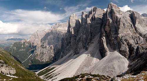 Einserkofel / Cima Una (left) and Oberbachernspitzen / Crode Fiscaline (right) Einserkofel / Cima Una (left) and Oberbachernspitzen / Crode Fiscaline (right) |
The Sexten / Sesto Dolomites are among the most spectacular mountain ranges on this planet. They are famous for many of their mountains, most of all the towers of Drei Zinnen / Tre Cime or The Sexten / Sesto Sundial, five mountains named after the time at which the sun appears above them when seen from the village itself (nine through one). Yet - since the range is one of the largest Dolomite Groups - there are a big number of mountains which tend to be overlooked, even though they might have been impressive in any other setting. In a range where the highest mountain, Dreischusterspitze / Punta dei Tre Scarperi is rarely mentioned, lower mountains seem to vanish.
The triplet of Oberbachernspitzen / Crode Fiscaline bears this distinction. Three summits are perfectly aligned with each other and one of the important mountains of the range, Einserkofel / Cima Una. All four tower above Altensteiner Tal / Val Sassovecchio, one of the main ascent / descent routes to or from the Drei Zinnen / Tre Cime Plateau. When seen from the norh, four massive faces make the mountains seen utterly inaccessible.
 |  |  |
However, from the south access turns out to be much easier than anticipated. A huge karst plateau leads up to the summit ridge and only Einserkofel / Cima Una stands out separately. Two of the three summits of Oberbachernspitzen / Crode Fiscaline can be reached by an easy hiking trail with breathtakingly exposed tops. Western Oberbachernspitze / Croda Fiscalina Ovest is the lowest of the three at 2635m and stands a bit aside, while Mittlere Oberbachernspitze / Croda Fiscalina di Mezzo (2675m) and Östliche Oberbachernspitze / Croda Fiscalina Est (2677m) appear to hug each other.
 |  |  |
The summits are very close to the border between the regions Trentino - Sädtirol / Alto Adige and Veneto, which follow the border between Austria and Italy before WW I. In consequence quite a number of trenches, caves and military positions have been carved out of the rock. Most positions can be found on the karst plateau but there are also several caves and tunnels on the summit ridge. They add to the military artefacts on Paternkofel / Monte Paterno to the west or Sandebühel / Collerana to the south.
 |  |  |
Needless to say that Oberbachernspitzen offer a wonderful panorama towards its neighbours within the range but also towards the Cortina Dolomites and Hohe Tauern. Most spectacular is the view towards the north-west face of neighbouring Einserkofel / Cima Una. Here the massive scar can be seen which was created by the rockfall of October 12th 2007, when a block of 60.000 tons broke away and disintegrated. This rockfall was filmed from Fischleintal / Val Fiscalina and can be viewed on Youtube:
360° Summit Panorama
  |
Getting There
 Drei Zinnen / Tre Cime seen across westliche Oberbachernspitze
There are several reasonable trailheads for a climb of Oberbachernspitzen / Crode Fiscaline. Most common is the start at the big parking lot of Rifugio Auronzo, a second is at Fischleintal / Val Fiscalina near Sexten / Sesto while a third starts at Dreizinnenblick Restaurant in Höhlensteintal / Val Landro.
From The North
- Take A22 Brenner Motorway to exit Brixen / Bressanone
- Turn off onto SS49 east to Bruneck / Brunico
- At Toblach Dobbiaco turn onto SS51, direction Cortina for Dreizinnenblick and Rifugio Auronzo
- For Fischleintal / Val Fiscalina stay on SS49 until you reach Innichen / San Candido. Here leave onto SS52
From Austria (East)
- Take A12 Inntalautobahn to exit Kufstein.
- Turn onto B178, later B161 south in direction Kitzbühel.
- At Mittersill B161 turns into B108 which heads through Felbertauern Tunnel.
- Take B108 to Lienz were you turn right (west) onto E66 which on the border crossing turns into SS49 to Bruneck / Brunico.
- Torn off at Innichen / San Candido or Toblach / Dobbiaco for your corresponding trailhead.
From Udine
- Take A23 north to exit Carnia.
- Turn off onto SS52 which leads through several detours to Sexten / Sesto.
- At Innichen / San Candido turn east onto SS49, then south onto SS51 direction Cortina.
From Venezia
- Take motorway A27 north towards its end near Belluno.
- Turn onto SS51 towards Cortina d’Ampezzo and on to Toblach / Dobbiaco. On SS51 you'll pass both intersections to Rif. Auronzo and Dreizinnenblick.
- Turn east onto SS49 to Innichen / San Candido.
- Turn onto SS52 to Sexten / Sesto
Routes
 In one of the saddles between the Oberbachernspitzen summits
 There are several routes leading to Oberbachernspitzen / Crode Fiscaline. They all converge at Buellelejoch/Forcella Pian di Cengia at 2522m.
- The easiest route starts at Rifugio Auronzo (large parking lot above a toll road) by following trail 104, which passes the south faces of Paternkofel / Monte Paterno, Passeportenkopf / Croda Passaporto and Bödenknoten. This access path takes between 90 and 120min to complete.
- Another possible route from Rifugio Auronzo leads across Paternsattel to Drei Zinnenhütte / Rifugio Locatelli and from there across Bödenalpe towards Buellelejoch/Forcella Pian di Cengia. This northern access takes some 2 1/2h to complete.
- A third route starts at Zsigmondy / Comici Hut to the east. The hut can be reached from Sexten / Sesto in about four hours while the ascent to Buellelejoch/Forcella Pian di Cengia takes little more than one hour.
From Buellelejoch/Forcella Pian di Cengia a marked path leads towards Oberbachernspitzen / Crode Fiscaline across a karst plateau with lots of remains from WW I. It meets the ridge between the western and central summit and then crosses over to the eastern summit.
Red Tape
In 1981 the Naturpatk Drei Zinnen / Parco Naturale Tre Cime has been established on the Südtirol / Alto Adige side of the Sexten / Sesto Solomites. It comprises 11.891ha in the north of the range. Oberbachernspitzen / Crode Fiscaline are located at the southern end of the park, close to the border with Belluno Province. The usual restrictions apply.The parking lot at Fischleintal / Val Fiscalina and the toll road to Rifugio Auronzo require fees, while the parking lot at Dreizinnenblick Restaurant is free.
Since the collapse of a pillar on neighbouring Einserkofel / Cima Una on Oct 12th 2007 parts of the karst plateau to the south of Einser and Oberbachernspitzen have been closed to the general public.
Accommodation
- Sexten / Sesto Accommodation
- Innichen / San Candido Accommodation
- Toblach / Dobbiaco Accommodation
- Misurina Accommodation
- Auronzo Accommodation
Weather Conditions
Maps & Books
Books
The Prags Dolomites / Dolomiti de Braies are not as well covered in terms of Guidebooks. The list below offers the German books I know of dealing with the area but there certainly are more, especially Italian ones.
- Dolomiten 5 - Sexten - Toblach - Prags
F. Hauleitner
Rother Verlag
ISBN: 3 7633 4199 4
- Dolomiten
P. Fleischmann
Kompass Verlag
ISBN: 3 8705 1409 4
Sextener Dolomiten extrem - Alpenvereinsführer
R. Goedeke
Rother Verlag
ISBN: 3 7633 1255 2
Maps
The most commonly used maps are the ones by Kompass and by Tabacco. The Kompass one is good as an overview map while the Tabacco one offers more details.
- Sextner Dolomiten / Dolomiti di Sesto
Kompass Map WK 625
ISBN: 3 8549 1749 X
Scale: 1:25000
- Sextner Dolomiten / Dolomiti di Sesto
Kompass Map WK 58
ISBN: 3 8549 1065 7
Scale: 1:50000
- Sextner Dolomiten / Dolomiti di Sesto
Tabacco Map 010
ISBN: 978-8883150104
Scale: 1:25000