
-
 16738 Hits
-
 90.81% Score
-
 33 Votes
|
|
Mountain/Rock |
|---|---|
|
|
46.64543°N / 12.31808°E |
|
|
Summer |
|
|
8586 ft / 2617 m |
|
|
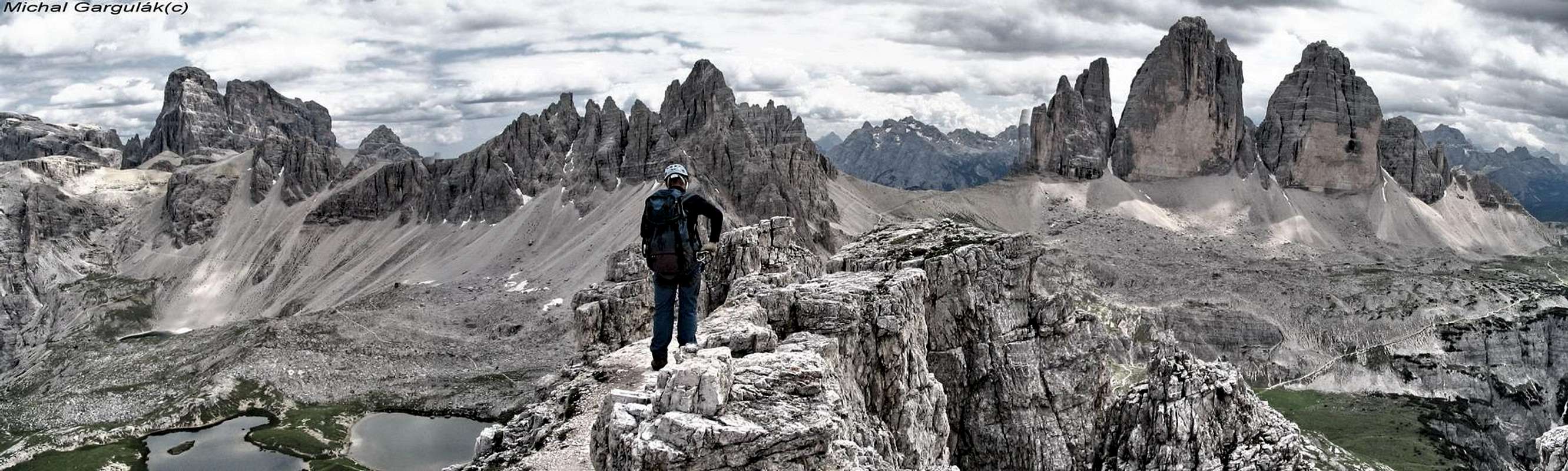
Toblinger Knoten
 Toblinger Knoten
Toblinger Knoten is a small rocky mountain in the Sexten / Sesto Dolomites. It is located directly behind Drei-Zinnen-Huette / Rifugio Locatelli. It rises 120mH high and on the top you have a fantastic (the best!) view to the north faces of the Drei Zinnen / Tre Cime. The small tower of Toblinger Knoten was a military position during the 1st World War, where soldiers made their duty in all weather the whole year. The way up to the summit begins 15 minutes after leaving the hut and you can reach the summit within 45 minutes. The route ist secured by fixed ropes and ladders. The route is sometimes a little bit exposed, so you need to be immune against vertigo. But this is a normal requirement for ascents in the Dolomites. The summit is very small, be careful, if the route is overcrowded. The descent is well secured and you can reach the hut in 30-45 minutes. The route requires 2 hours up and down, so there is time enough to do Toblinger knoten and Paternkofel / Monte Paterno on one day. Difficulty: The via ferrata is not very difficult, but exposed and steep! KS4-B
The via ferrata follows the historical route of the soldiers to the summit and is ca. 160 meters long and has 17 ladders. You can see on your way up some old rotten wood ladders and material-depots. Very interesting! The summit was the main-military-position of the austrian army in 1915. The soldiers had fought on a distance of 300 meters against the italian army. This route was built in 1917 because the normal route (now the descent) couldn´t be used any more by daylight, because it was on the visible side to the italian army. In 1978 the route was renovated.

Getting there
Origin for this tour is Drei-Zinnen-Huette / Rifugio Locatelli, you reach it from Refugio Auronzo in 1 hour. You reach Rifugio Auronzo by toll road (20 Euro ~ $25 !!!) from Misurina. At the Rifugio Auronzo is a big parking. It is located directly at the south flank of Drei Zinnen. Misurina is located 20 minutes east of Cortina d´Ampezzo and 30 minutes south of Toblach / Dobbiaco.

 Looking towards Toblinger Knoten Looking towards Toblinger Knoten |  On the summit On the summit |  Looking up Looking up |
|---|
Bor - Sep 8, 2007 6:15 am - Voted 10/10
Cordinates!Please add it: Latitude=46.64543°, Longitude=12.31808° I add the descriptions of both ferratas. Cheers!