eTrex Vista HCx
Product Description
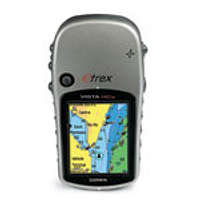
The eTrex Vista HCx has a high-sensitivity, WAAS-enabled GPS receiver that holds a GPS signal in the toughest environments. The Vista HCx will maintain your location even in heavy cover, or deep canyons. This handheld navigator also has a bright color screen, barometric altimeter, electronic compass, microSD card slot and automatic routing for wherever adventure takes you. You can add topographic maps to the Vista HCx through the micro SD card slot.Features
Automatic routing, electric compass, barometric altimeter, geocaching-friendly, outdoor GPS games, hunting/fishing calendar, sun and moon information, area calculation, ability to add additional points of interest, accepts microSD cards, and has a 25 hour battery life.External Links
eTrex Vista HCxImages
 |  |  |  |
Reviews
Viewing: 1-4 of 4 |

Eric Sandbo - Apr 7, 2010 5:03 pm - Hasn't voted
Good topos
Our team used one on a search in fog and snow near Sahale Mountain, WA last year. The topo maps stored in the Vista HCx are a duplicate of the USGS 7.5' maps, allowing us to see the big picture when we couldn't see beyond 200 feet/60 meters in the fog. The marked GPS location was off a bit, but the contours on the displayed map allowed us to determine exactly where we were. It allowed us to make a big circuit over difficult terrain that none of us had been on, in almost no visibility. If I ever shell out the money for my own GPS, the Vista HCx is at the top of my list.

EverydayExplorer - Apr 30, 2011 4:27 pm - Voted 4/5
Great Device Awful Software
The HCx is a great device. The signal is strong even in moderate cover. My main issue is the software which is awful, especially if you have a Mac. Once you figure out the work-arounds you need on the software side you'll be fine for the basics but it is a pain. Overall I'd recommend it because what really matters is navigating the mountains and it is great for that.

Redwic - Nov 12, 2014 12:06 pm - Hasn't voted
Very durable
I have had my GPS for over 7-1/2 years. It has been very reliable, especially the altimeter and waypoint features. The GPS has been dropped on hard surfaces and scratched on more than one occasion, yet still works. But alas, I will likely need a new one soon.
Viewing: 1-4 of 4 |
asaking11 - Jun 7, 2009 3:42 am - Voted 5/5
Overall an awesome GPS