
|
|
Mountain/Rock |
|---|---|
|
|
37.11186°N / 118.53081°W |
|
|
Fresno, Inyo |
|
|
13893 ft / 4235 m |
|
|
Overview
Rising to 13,891 feet Mount Agassiz is one of the tallest peaks in the Sierras. It ranks as the twenty-first tallest peak in California, and it has a strong presence in the Palisades region. Situated as the first mountain to the southeast of Bishop Pass, Mount Agassiz sits back to back on a ridge with a number of 13,000 foot peaks and five of the state’s 14ers. The two mile long ridge to the south includes Mount Winchell, Thunderbolt Peak, Starlight Peak, North Palisade, Polemonium Peak, and Mount Sill.
The Palisades are considered one of the best alpine climbing locations in the Sierra Nevada. This area hosts a variety of challenging rock climbs and other considerable scrambles during the summer months. During the winter on the other hand, the Palisades offer expert and extreme ski descent possibilities on a number of couloirs.
Mount Agassiz makes for an excellent overnight climb, sometimes climbed with nearby Mount Goode on the other side of Bishop Pass. It is also done in a strenuous day as the South Lake Trailhead begins at relatively high elevation (9,800 feet). The most utilized routes up Mount Agassiz are moderate scrambles with class 2-3 rock leading to views in all directions of alpine lakes, high peaks, and one mile to the south of the largest glacier in the Sierra Nevada.
 |
 |
 |
 |
 |
 |
Getting There
Agassiz from Bishop Pass Trail
Agassiz from Dusy Basin
The most commonly used trailhead for trips to Mount Agassiz is the South Lake Trailhead leading to the west slope above Bishop Pass. The Glacier Lodge trailhead is used to reach the routes to the south and southest. Both trailheads are in Inyo National Forest.
South Lake Trailhead (37.16928° N, 118.56568° W)
Turn west off Highway 395 in Bishop onto Highway 168 (W Line Street) towards Lake Sabrina. Follow Highway 168 for 15 miles to the well marked intersection with South Lake Road. Follow the road to South Lake for 7 miles to the parking area at the end of the road.
Glacier Lodge (37.12545° N, 118.43714° W)
Turn west off Highway 395 in Big Pine onto Glacier Lodge Road (W Crocker Street) and follow it 10.5 miles directly to the trailhead parking area at the end. There is a small lot for day use, but if full or going on an overnight trip you'll need to use the backpackers' lot 3/4 mile down the road.
Route Overview
The most popular route up Mount Agassiz is the class 2 West Slope via Bishop Pass. The route can also be made mostly solid class 3 depending on your precise route selection… there are many possible variations and route finding is a non-issue.
See the route table below for other available options and the identified route pages for additional details.
| Route | Trailhead (Quota Area) | Difficulty | Distance (one way) | Elevation Gain |
|---|---|---|---|---|
| West Slope from Bishop Pass | South Lake (Bishop Pass) | Class 2 | 6.1 miles | 4200 feet + 100 feet on return |
| Southeast Side via Agassiz Col | Glacier Lodge (Big Pine North Fork) | Class 2 | 9.0 miles | 6400 feet + 200 feet on return |
| East Ridge | Glacier Lodge (Big Pine North Fork) | Class 4 | 8.6 miles | 6400 feet + 200 feet on return |
| Northeast Face | Glacier Lodge (Big Pine North Fork) | Class 5.2 Grade II | 8.7 miles | 6400 feet + 200 feet on return |
| Rolling Stones | Glacier Lodge (Big Pine North Fork) | Class 5.8 Grade III | 8.7 miles | 6400 feet + 200 feet on return |
Red Tape
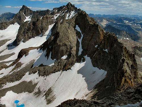
The Inconsolable Range from Agassiz
Wilderness Permits:
The route to Mount Agassiz is on Inyo National Forest land. No permits are required for day trips but overnight trips require one throughout the year. Permits for can be picked up at the White Mountain Ranger Station in Bishop or any other Inyo National Forest office. Quotas are in place May 1 through November 1. Check the Inyo National Forest wilderness permit website for the most current information and reservation availability.
Food Storage:
Bear canisters are not required but proper food storage is important.
Campfires:
Fires are prohibited above 10,400 feet within the John Muir Wilderness boundary.
Inyo National Forest Wilderness Permit Office
351 Pacu Lane, Suite 200
Bishop, CA 93514
Wilderness Information Line: (760) 873-2485
Permit Reservation Line: (760) 873-2483
Current Conditions
Current NOAA / National Weather Service Forecast
When To Climb
Spring through fall is the normal season, however winter ascents and ski tours are possible as the approach is quite moderate. Contact Inyo National Forest in the off season for road conditions.
 |
 |
 |
 |
 |
 |
Camping
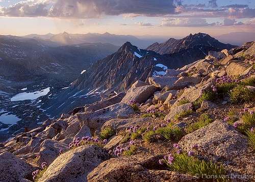
The Palisades from the Summit of Mount Agassiz
Mount Agassiz is possible as a daytrip, but the area is also popular as an overnight destination. There are many scenic alpine lakes encountered on the approaches, all making excellent overnight destinations. Saddlerock Lake and Bishop Lake are great options and well situated for the West Slope route. Dusy Basin is also available for those seeking a bit more solitude. If climbing routes to the east there are many options including any of the Big Pine Lakes, Sam Mack Meadow or Sam Mack Lake, and several tarns around Mount Agassiz or the Palisade Glacier.
If completing a daytrip, dispersed camping is allowed in Inyo National Forest, including a handful of areas along or just off Highway 168 from Bishop to South Lake. Even better, there are literally hundreds of roadside camping options in Buttermilk Country, located off Buttermilk Road (north of Highway 168). There are outstanding views of Mount Humphreys, Basin Mountain, Mount Tom, and White Mountain Peak from throughout the area.
Established campgrounds are abundant along the road to South Lake and in the immediate vicinity of both the South Lake and Glacier Lodge trailheads. There are also additional options nearby further up Highway 168 en route to Lake Sabrina. See the Inyo National Forest Campground Camping page for details.
Etymology
"Louis Agassiz (1807-1873), a naturalist, geologist, and teacher. He was born in Switzerland, came to the United States in 1846, and became a professor of zoology at Harvard in 1848. Lilbourne A. Winchell, in 1879, gave the name 'Agassiz Needle' either to this peak or to what is now Mount Winchell, a truly needlelike peak 0.7 mile southeast of Mount Agassiz. (Winchell, 160.) The name change from 'Agassiz Needle' to 'Mount Agassiz' was proposed by the Sierra Club in the 1930s. (SC records in BL.) The name 'Agassiz Col' first appeared on the 1948 Mt. Goddard 15' map." – Peter Browning, Place Names of the Sierra Nevada (2004)

