
-
 4219 Hits
-
 86.85% Score
-
 23 Votes
|
|
Mountain/Rock |
|---|---|
|
|
46.32883°N / 12.07702°E |
|
|
Veneto |
|
|
Trad Climbing |
|
|
Summer, Fall |
|
|
7530 ft / 2295 m |
|
|
Overview
Geographical classification: Eastern Alps > Dolomites > Moiazza Group > Pala del Belia
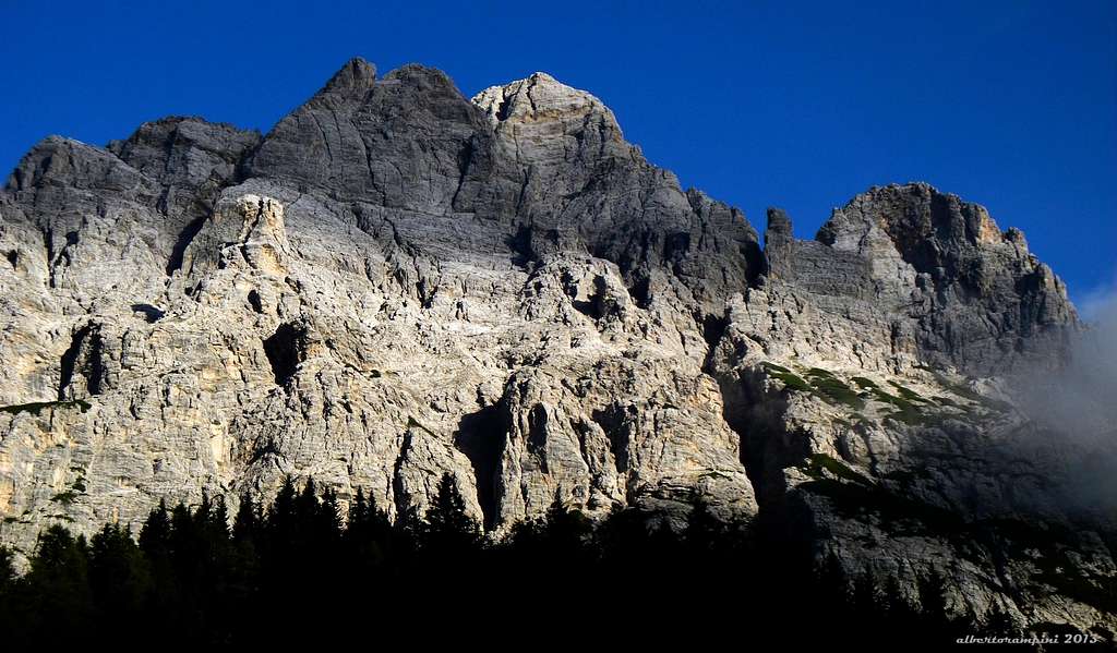
Pala del Belia m. 2295
Often considered as a sector of the neighbouring Civetta Group, Moiazza is now regarded as an autonomous area. The group is located between Valle Agordina and Val di Zoldo, Eastern Dolomites, and dominates the village of Agordo and Passo Duran m. 1605, a col connecting Agordo and Forno di Zoldo. This wide col is located in a fine position between San Sebastiano - Tamer Group to the South and Masenade - Cantoni del Duran subgroup, to the North. This latter is the South-Eastern uttermost part of the Moiazza area and shows a large number of rocky towers and needles, built in a very good grey and yellow “dolomia”, just a paradise for skilled climbers, lying in the neighbourhood of Passo Duran.
Moiazza seen from Passo Duran
The Masenade protrudes to the South a huge shoulder, overlooking both Col dei Pass, where the “Bruto Carestiato” Hut is located, and the path n. 549, joining the hut and Passo Duran. It’s Pala del Belia, an imposing great tower, showing a high quality “dolomia”. Some fine stunning routes are running on its sunny South face.

|

|
Getting There
Road access
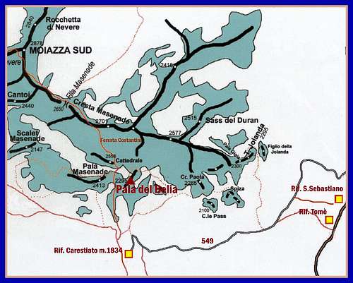
The nearest town is Belluno. From Belluno there are two possibilities to reach Passo Duran:
A. Via the Val di Zoldo - From Belluno take the road 50 to Ponte nell’ Alpi, then the road 51 getting to Longarone; in Longarone turn to left, following the road 251 to Forno di Zoldo m. 810. Pass Forno di Zoldo the road forks; turn to left taking the road 347 rising steeply to Passo Duran m. 1605 (40 km from Belluno)
B. Via the Valle Agordina - From Belluno take the road 203 to Mas, entering the Canale d’Agordo valley and reaching Agordo. Some hundred meters before the town, turn to right and take the road 347 rising to Passo Duran m. 1605 (32 km. from Belluno)
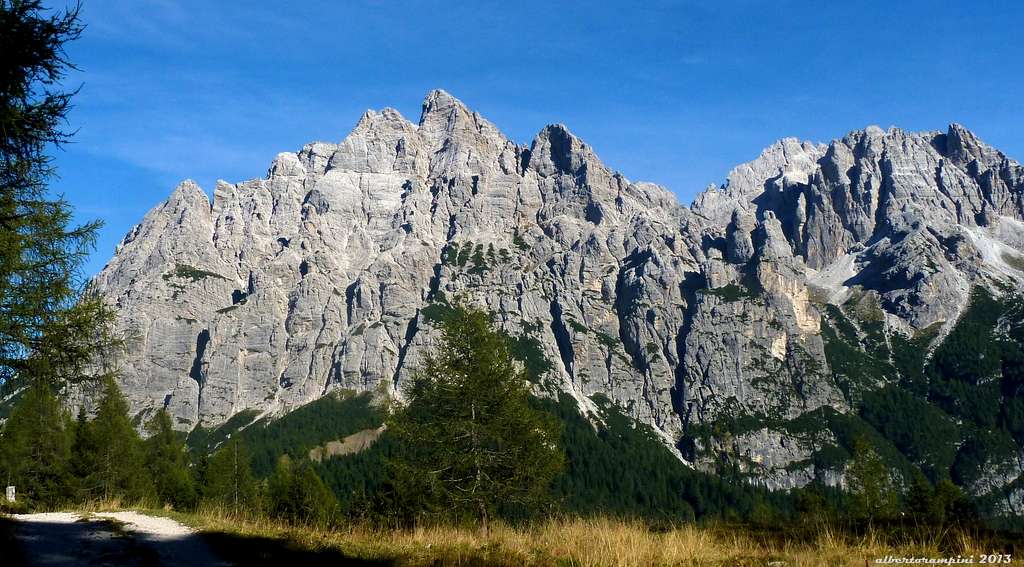
San Sebastiano - Tamer Group seen from the path to Rif. Carestiato
Walking approach to Rifugio “Bruto Carestiato” m. 1834
Starting from Passo Duran take the path n. 549, rising steeply amongst the meadows and joining a gravel road leading to the hut (40 minutes from the col).
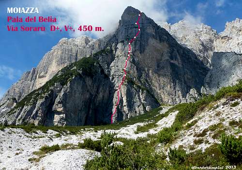
Via Sorarù report
Via Sorarù - Pala del Belia
Summit altitude: m. 2295
Difficulty: D sup., UIAA V+
Equipment: some pegs
Climbing length: 450 m.
Exposure: South
First ascent: Giuseppe Sorarù - E. Amodruz - S. Pelozo 4 Aug 1957
Starting point: Passo Duran or Rifugio Carestiato
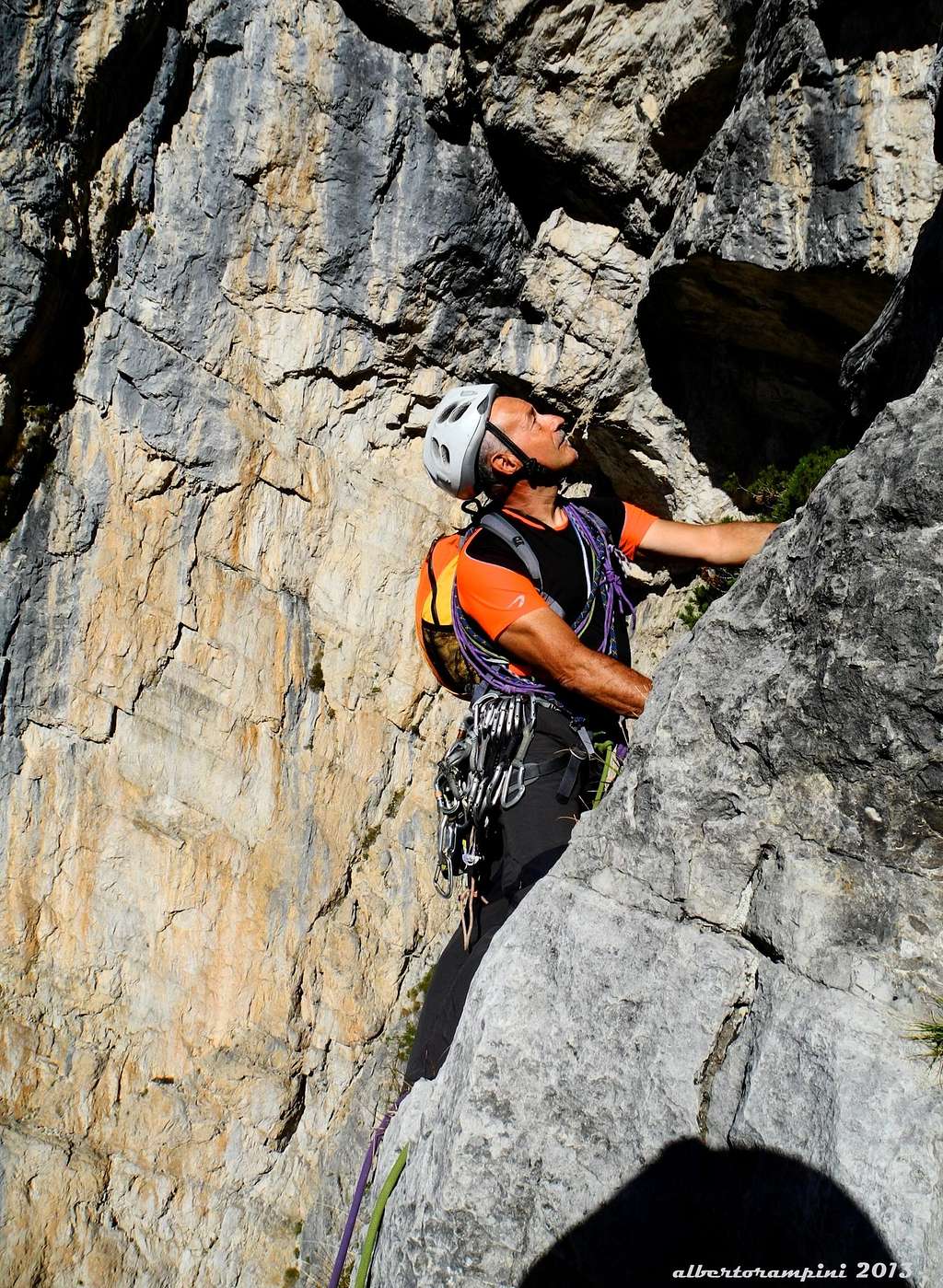
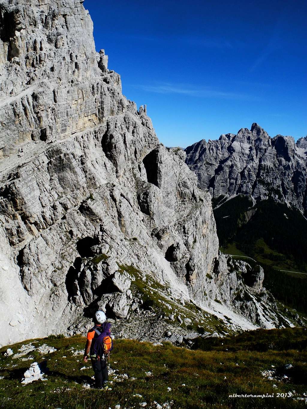
On Sorarù lower section |
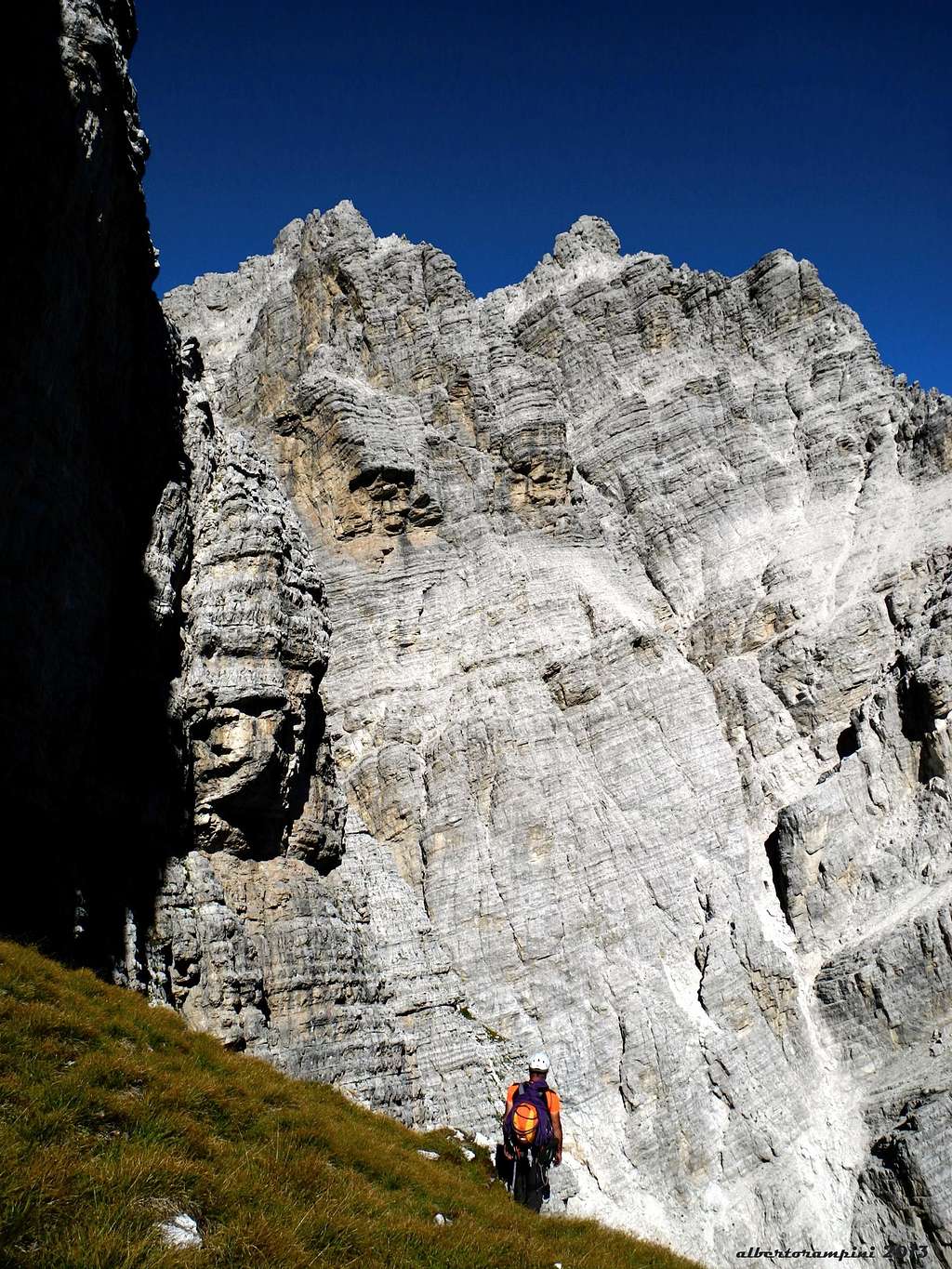
Pala del Belia summit view |
Via Sorarù climbing report - UIAA scale
A very fine classic climb, running on the obvious South edge of Pala del Belia. The climbing style is pleasant and various on ridge, slab, corners, cracks and chimneys.
Approachs
- From Passo Duran take the path n. 549, rising steeply to join a gravel road leading to Rifugio Carestiato. Before reaching, nearby a large hairpin, leave the road and take on the right a narrow path rising amongst the dwarf-pines to the bottom of the face, showing huge yellow overhangs on on the right side (50 minutes from the col).
- From Rifugio Carestiato the approach is quite brief: follow the path to Via Ferrata Costantini to the base of the rocks, then skirt the face to the right gettin the starting point of the route (10 minutes from the hut).
Sorarù topo
L1 – Climb a dihedral on the left of the edge, then go slanting right to the edge and climb directly a wall with good holds. After some dwarf pines, belay on a terrace with a larch. IV, 50 m. L2 – Climb slanting left to the base of a dihedral, climb it entirely, then on easier ground to a narrow ledge. IV+, 50 m. L3 – Traverse right on the ledge towards the edge, then climb on rocky steps a few meters on the left of the edge to the grassy slopes marking the first quarter of the face. L4 – Up the slopes to the base of a dihedral-crack, becoming a chimney in the upper part. L5 - Climb the dihedral-crack to a narrow belay under the upper chimney. IV, 30 m. L6 – Climb the fine chimney, then belay under a grey overhang. IV+, 35 m. L7 – Up a thin crack below the roofs, then climb slanting right to a belay. V, 15 m. L8 – Climb an overhang on its right end, then slanting left to a grey slab. Climb the slab to a belay V+, 50 m. L9 - Climb a little wall, then up a grassy sector to a corner. V, 40 m
On the descent route |
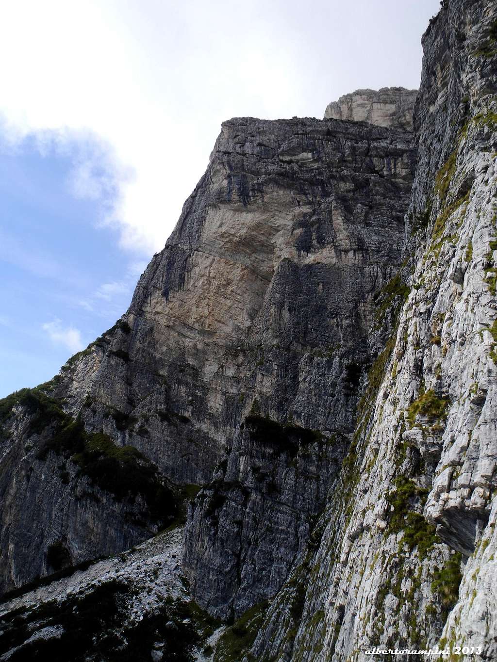
Pala del Belia seen from Pala del Bo |
L10 – Up the corner. Belay on a flake. IV+, 35 m. L11 – Go to right round the edge, then climb a slab side by side with a dihedral; slanting left to an edge with a yellow hole, then exit on a ledge. Traverse left the ledge and belay under a slanting crack. V, 55 m. L12 – Climb the wall on the right of the crack, up a little overhang, then take the dihedral. Belay on a narrow ledge. IV, 40 m. L13 – Up the last hard meters in the dihedral, then slanting right, reaching the exit ledge. Scramble up heading left to reach the summit cairn.
Descent: from the summit cairn follow a grassy ridge, then head to right walking down along steep grassy slopes to the deep gully dividing Pala del Belia from the neighbouring Pala del Bo. Cross the head of the gully, reaching the summit of Pala del Bo. From here scramble down towards right to grassy and scree slopes, getting to the bottom of the walls and then to the approach path.
Essential gear
Ropes 2x50, helmet, 10 quickdraws, some friends, slings
Other routes
Other interesting routes from left to right:
- Via Penasa D-, V, 550 m. Attilio Penasa - Giuseppe Lise 4 Oct 1947 The route is running on the left of Via Sorarù, joining it on some pitches in the middle section, then heading left.
- Via Costantini TD, V+, VI, 400 m. G. Costantini - A. Sonego - F Dal Magro 24 Jul 1966 This route, running on the right of Penasa and Sorarù, is quite largely harder then the previous ones.
Where to stay
Passo Duran m. 1605 is the starting point to climb the routes located in the Masenade-Cantoni del Duran subgroup. There are two accommodations on the col:
- Rifugio Cesare Tomè C.A.I. 30 places Guardian: Soro Dorotei Phone: +39043765199 Rifugio Cesare Tomè
- Rifugio San Sebastiano , private, 30 places, always open, located just on the pass. Phone: +39043762360 Rifugio San Sebastiano
Another possibility is:
- Rifugio Bruto Carestiato m. 1834, CAI 50 places, located at 40 minutes by walking from Passo Duran Phone: +39043762949 Guardian: Fam. Diego Favero Rifugio Bruto Carestiato
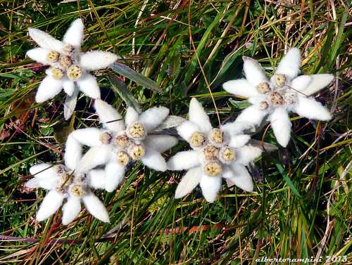
Leontopodium alpinum or Stella Alpina or Edelweiss. Picked up without pity, about 20 years ago this beautiful alpine flower became a rarity; the botanist Pignatti declared it as a species on the way of extinction. Today, due to an increasing environmental sensitiveness, the Queen of the Alps is coming back to spread on the rocks and the slopes, sometimes even near the paths
Red Tape
There are not particular restrictions in climbing and hiking.

When to climb
Best season goes from June to October
Meteo
ARPAV DOLOMITI METEO
DOLOMITI METEO VENETO
DOLOMITI METEO Phone +390436780007 fax +390436780008 CENTRO VALANGHE DI ARABBA Phone +390436755711 fax 043679319 e-mail cva@arpa.veneto.it
Guidebooks and maps


- Guidebooks
“IV grado in Dolomiti – Vol. II” by Emiliano Zorzi, Idea Montagna edizioni, 2010
“IV grado e più – Dolomiti Orientali” by Emiliano Zorzi – Luca Brigo – Carlo Piovan, Idea Montagna Edizioni, 2012
“Moiazza – Roccia tra luce e mistero” 163 itinerari in Moiazza by Stefano Santomaso, Idea Montagna 2011
“Arrampicate scelte sul versante meridionale della Moiazza” by Soro Dorotei, 1994
"Civetta - Moiazza” – V. Dal Bianco – G. Angelini Tamari Editori in Bologna, first edition 1970, last edition 1984 (Last update in 1970)
- Maps
Kompass 1:50000 n. 77 Tabacco 1:25000 n. 15