
|
|
Mountain/Rock |
|---|---|
|
|
35.83340°N / 52.29610°E |
|
|
Hiking, Mountaineering, Bouldering |
|
|
Spring, Summer, Fall, Winter |
|
|
13074 ft / 3985 m |
|
|
Overview
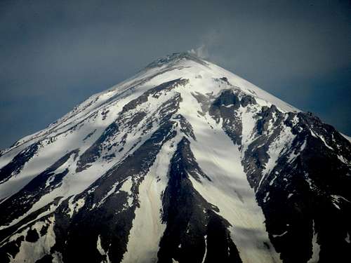
Mt. Pashooreh is located in the eastern part of central Alborz. To the south it is limited by Lasem valley, and to the west it is limited by Haraz road. Mt. Pashooreh consists of a main ridgeline, in a SW-NE direction, and several neighboring peaks . The highest peak on the ridge (Pashooreh peak) is the one in the northernmost part as shown in the following picture.
Regarding the elevation of the Pashooreh peak, different sources show different numbers ranging from 3870m to 4010m. There is a sign on the summit of Pashooreh showing the elevation as 3985m, and I used that one as reference.
It should be mentioned that although the whole mountain is known as Mt. Pashooreh, the highest peak is not Pashooreh peak. In fact Pashooreh peak is the highest point on the ridgeline, not the highest point of the mountain. The highest peak is Halzam located to the NE of Pashooreh peak with the elevation of 4050m (according to the map published by Iran mountaineering federation). The same map shows the elevation of Pashooreh 4010m.
The most popular route to climb Mt. Pashooreh is the one starting from the village of Nava, a very beautiful village off of Haraz road. This route is very scenic and the view is amazing.

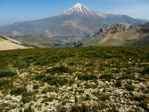
After about half an hour hiking from the village of Nava, you will reach a kind of flat area called Azoo plateau. It is a very nice area with an amazing view of Mt. Damavand.


There is a mud house in Azoo plateau where mountain climbers usually stop there to take a rest.
 The mud house
Here are some more views from Azoo plateau:


From Azoo plateau the most straightforward route to the summit of Pashooreh is the one going towards Ebrat pass. From Ebrat pass you should go to the left and continue all the way to the end of the ridgeline.
 Ebrat pass
Here are some pictures I took on my way to Ebrat pass:

 Mt. Gole-e-zard


 Ebrat pass
Pashooreh in persian language means something that can be used to clean or wash feet. The reason this mountain is called Pashooreh is the fact that there is an area there where you can find some special type of stones (very similar to pumice stone) that people, specially in the villages, use to clean the sole of their feet. It is a very effective way to get rid of cracked feet. I am not quite sure if these stones are really pumice stones or not. The following picture shows the area with those stones.

When you reach Ebrat pass the view is amazing. On one side it is dominated by Mt. Damavand, and on the other side it is dominated by Doberar-Gharehdagh ridge. From Ebrat pass you should continue to the left and go towards Pashooreh ridge. Here are some pictures:


One side of the Pashooreh ridge is rocky with several rock walls but the opposite side has gentle slopes on the higher elevations and steeper ones on the lower elevations.

Here are some pictures from different spots on the ridgeline:


Here are what you see when you are on the summit of Pashooreh:
 The summit of Pashooreh, 3985m.

 Mishineh marg
 Halzam peak


Here are some more pictures I took on my way back to the village of Nava:
 Halzam peak
 Doberar peaks
 Nava, Niak and Rineh
 What is this?


Getting There
To get to the village of Nava, you need to take Haraz road. After about 60km you will get to the village of Polour. If you continue for another 15km you will get to the village of Ab-e-ask. Keep going for another 5km and there is an exit on the right. Take the exit and go for about 9km and you will be in the village of Nava. You can park your car next to "Nava mineral water" factory, and start your hike from there.Another popular way is to go to the village of Lasem, and start the hike from there. To get to the village of Lasem, you need to take Haraz road. About 2km after Polour there is an exit on the right. Take the exit and go for about 14km and you will be there.