
|
|
Mountain/Rock |
|---|---|
|
|
40.76086°N / 110.0701°W |
|
|
Duchesne |
|
|
Hiking |
|
|
Summer |
|
|
11896 ft / 3626 m |
|
|
Overview
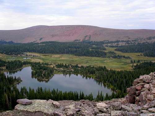
Peak 11896 as seen over Reader Lakes
Unnamed Peak 11896 is an obscure peak located in the eastern Uintas of Utah. According to listsofjohn.com, it is the 96th highest peak in the state with over 300' of prominence, having a prominence of 427'. No registered user of listsofjohn has yet climbed the top 100 peaks of Utah. Anyone desiring to do so must climb this one to meet their goal. As a contrast, the top 100 peaks of Colorado have been climbed by 43 registered users (as of 9/19/2012).
Peak 11896 is located in a very pretty area with many mountain lakes and is in the same vicinity as the Duchesne County highpoint Eccentric Peak. Those climbing Eccentric Peak from Chepeta Lake and wanting to do another short trip in the area might consider this peak. To climb it directly it is 5.7 miles round trip and would only take a few hours. To do a loop hike that also hits the four 12000 footers, East and West Burnt Fork Peaks (both 12666'), Taylor Peak (12620'), and Walk up Peak (12365'), is 16.5 miles round trip and would take all day.
Getting There

Park here
It is about a 4 hour drive to the start of the hike from Salt Lake City.
Find your way to Roosevelt Utah. If coming from Salt Lake City, take I80 east to exit 146 (route 40). Head east on route 40 about 115 miles to the center of Roosevelt.
At the intersection of 200 North and 200 East where route 40 makes a right angle turn at a traffic light, head west on 200 North. This shortly will become route 121 East. Follow route 121 east 10 miles to the town of Neola where it makes a right hand turn. Make the right hand turn and continue on 121 for 5.3 miles where it T's. Turn left off of route 121 which continues to the right.
Go 10.4 miles and turn left at N40.54845 W109.95478 heading in the direction of Chepeta Lake. The road changes from pavement to dirt. If you miss this turn and go straight, the road deteriorates into a poor dirt road quickly.
Go another 14.1 miles and turn right at N40.67518 W110.04548, heading in the direction of Chepeta Lake. (Going straight gets you to Pole Creek Campground.)
Go another 9 miles to N40.76794 W110.02695 where there is a very nice flat spot to park on the left, just past a big meadow.
In the summer of 2012 I found the dirt road to be in great shape and a passenger car should have no problem with it but there are a few short sections where you have to go slow. It winds around a bit but except for the turns I've mentioned, you should always follow the main road.
Red Tape
None that I know of. This peak lies just outside the High Uintas Wilderness boundary.Camping
The closest campground is the Pole Creek Lake Campground, which is located about 10 miles away from the start of this hike. However, you should have no problem finding a place to camp along the road closer to the start of the hike.When to Climb
Most years, the beginning of July through the end of September would be suitable. The access roads are not plowed in the winter.Routes Overview
DirectTo climb this peak directly, park at N40.76794 W110.02695 and make a beeline for the east ridge of minor Point 11689. Head up the ridge. When you are close to the main ridge, start contouring to the south and then follow the main ridge to the summit of Point 11896 where you will find a large carefully constructed cairn and a big flat rock with a benchmark. This hike is 5.7 miles long round trip and gains 1436 feet in elevation. I did this hike in the beginning of August and found the swamp marked on the map to be only a little wet. If you do it earlier in the year, you may want to start further south on the road to avoid the swamp. |  Map |  The summit |
Loop
It is convenient to do a loop hike encompassing this peak as well as the four 12000 footers, "East Burnt Fork Peak", "West Burnt Fork Peak", "Taylor Peak", and "Walk Up Peak". See the Reader Lakes Loop page for details.
Mountain Weather

A storm is about to hit the top of Peak 11896
Here is a link to the current 7 day forecast for Peak 11896.
If you are only planning to climb Peak 11896 and you get an early start, you may have time to finish before any bad weather arrives. However, if you are to do the loop hike I've described, it will take you most of the day and you need to be very wary of thunderstorms.