
|
|
Mountain/Rock |
|---|---|
|
|
40.75021°N / 109.79133°W |
|
|
Uintah |
|
|
Hiking, Mountaineering, Scrambling, Skiing |
|
|
Summer |
|
|
11139 ft / 3395 m |
|
|
Overview
Peak 11,139 is an obscure summit in the Eastern Uinta Mountains. It is a low, dome like peak which would normally be considered to be nothing out of the ordinary if it weren’t for two unique superlatives. Of all the peaks in the Uintas, this is the last peak when going east that rises above timberline (some sources list Marsh and Leidy Peaks as holding this superlative, but this is in error). I propose the name “Timberline Point” for Peak 11,139 because of this. East of Timberline Point the Uinta Mountains continue for many miles, but none of the peaks are alpine. To the east of Timberline Point they are thickly forested and mostly rounded with scattered meadows before lowering to the spectacular and rugged desert peaks near Dinosaur National Monument and vicinity. Going east, you wouldn't hit another peak above timberline for 180 miles!The peak is a rather generic dome with no other climbing difficulties except for thick timber and fallen logs. Other than this, the peak is an easy ascent, although almost no one ever climbs it. The peaks to the immediate west are much higher and more visible than Timberline Point.
Most of the trails in this eastern section of the Uintas are not used much, and many are fading away because of very light or no foot traffic. Even though the peaks are easy to climb, and not very rugged, this is a good place to go come to if you enjoy solitude. Many trails are shown on the topo maps, but many of them don't exist anymore.
Like all peaks in the Uintas, except for Bald Mountain, Timberline Point has no trail to the summit. It can easily be climbed in a day.
The Uinta Mountains are one of the few mountain ranges in North America that run east to west rather than north to south. Within the Uinta Mountains are about 2000 lakes, and some 900-1000 are full of trout. Along with the San Juans in Colorado, the Uintas have more contiguous area above timberline than any other area in the Continental United States. This is a beautiful area with many lakes, meadows, wildflowers, and some rugged peaks. Solitude is usually easy to come by once you leave the popular fishing holes behind.
The Uinta Mountains are very rugged in the northeast section. Beginning at Hayden Peak and east to Mount Lovenia, the Uintas are not unlike the Tetons or other ranges. East of Lovenia, the peaks are more gentle, with a few rugged peaks (ie Red Castle and Henrys Fork Peak) scattered about until you are as far east as the Henrys Fork/Kings Peak area. East of Kings Peak, the Uintas become very gentle and the peaks are very rounded with only a few scattered cliffs about.
 Big cairn on the ridge west of Timberline Point.
Getting There
Highline Trail/Hacking Lake TrailheadFrom near the center of Vernal along Highway 40, turn north at the sign for Maeser and follow the road north to 500 North. Turn west here and follow 500 North to 3500 West. Turn north here. There is a sign for Red Cloud Loop Road. Follow the Red Cloud Loop Road through Dry Canyon. If you have time, make sure to stop at the pictographs and petroglyphs along the way.
The road becomes a good gravel road at the Forest Service boundary. Follow the Red Cloud Loop all the way to a major junction with the road to Hacking Lake. A sign points the way to Hacking Lake, and follow the road to near Hacking Lake. Instead of turning left at the lake, follow the main road right and to its end. This is the trailhead.
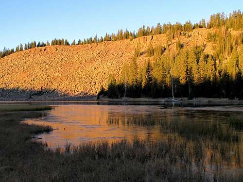 Hacking Lake.
Ashley Twin Lakes Trailhead
From near the center of Vernal along Highway 40, turn north at the sign for Maeser and follow the road north to 500 North. Turn west here and follow 500 North to 3500 West. Turn north here. There is a sign for Red Cloud Loop Road. Follow the Red Cloud Loop Road through Dry Canyon. If you have time, make sure to stop at the pictographs and petroglyphs along the way.
The road becomes a good gravel road at the Forest Service boundary. Follow the Red Cloud Loop all the way to a junction with the road to Ashley Twin Lakes. A sign points the way to Ashley Twin Lakes, but be aware of missing signs as they tend to disappear. Follow the road towards Ashley Twin Lakes. It quickly becomes a 4wd road.
Ignore the side tracks and stay on the main track until you reach the end of the rough road. Cars will have to be parked earlier.
Park here. This is the trailhead.
Routes Overview
Via Highline Trail and Hacking LakeThe route below might be the easiest route to Timberline Point, but it is not the shortest. Most of the route stays above timberline, but there is a section of tedious logs to cross at the final saddle before the summit.
This route follows the northwest ridge of Timberline Point. See the route page for map and details.
Other Routes
Because Timberline Point is not a rugged peak, it can be climbed from every point on the compass. The major obstacle is deadfall which can be very thick, especially in the north side of the mountain.
Because of the deadfall, the route above is the easiest route since it stays above or near timberline for most of the route.
 Timberline Point from the west.
Red Tape
No permits are required. This is outside the official wilderness area, but normal wilderness rules apply.Camping
If you like camping with not many restrictions, and without the crowds, this is a good place to come.The road to the Highline Trail and Hacking Lake has many good campsites, including at the trailhead.
Dry Fork, on the road to the Ashley Twin Lakes Trailhead has many nice campsites in the forest, some with picnic tables and fire places. All are free of charge! There are other campsites closer to the trailhead along the road, including near the trailhead.
This is really too short of a climb for most people to want to consider an overnighter, but you could camp in the pretty basin to the south if you are coming from Ashley Twin Lakes.
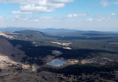 Timberline Point is in the background while Lakeshore Basin is seen in the foreground. There are many campsites in the basin below.
When to Climb
Mid-July through Mid-September is the normal hiking season. The roads in the area are usually open in late June or early July. They usually close when ever the first big snowstorm of the season hits, usually between mid-September and mid-October.In summer, this is a short climb, especially by Uinta Mountain standards. This is not true in winter. None of the roads in the area are open in winter. I don't know if the mountain has ever been climbed in winter, but if you could use a snowmobile to get close, it would be an easy climb.
 Leidy Peak as seen from the ridge to Timberline Point. October 7 2012. Usually Leidy Peak has a big snowfield on it, but it was gone this year.
Mountain Conditions
Contact the ranger station in Kamas for current road and trail conditions. Their phone number is 801-783-4338.Click Here for Weather Forecast for Timberline Point
Here are some average highs and lows from the 12,139 foot elevation (3700 meters) in the Uintas (about the same altitude as the summit):
| MONTH | HIGH | LOW |
| JAN | 14 | -1 |
| FEB | 16 | 1 |
| MAR | 19 | 4 |
| APR | 27 | 11 |
| MAY | 35 | 18 |
| JUN | 45 | 25 |
| JUL | 55 | 32 |
| AUG | 53 | 31 |
| SEP | 45 | 24 |
| OCT | 34 | 15 |
| NOV | 22 | 8 |
| DEC | 17 | 3 |