
|
|
Mountain/Rock |
|---|---|
|
|
40.76800°N / 109.833°W |
|
|
12028 ft / 3666 m |
|
|
Overview
The Uinta Mountains are one of the few mountain ranges in North America that run east to west rather than north to south. Within the Uinta Mountains are about 2000 lakes, and some 900-1000 are full of trout. Along with the San Juans in Colorado, the Uintas have more contiguous area above timberline than any other area in the Continental United States. This is a beautiful area with many lakes, meadows, wildflowers, and some rugged peaks. Solitude is usually easy to come by once you leave the popular fishing holes behind.The Uinta Mountains are very rugged in the northeast section. Beginning at Hayden Peak and east to Mount Lovenia, the Uintas are not unlike the Tetons or other ranges. East of Lovenia, the peaks are more gentle, with a few rugged peaks (ie Red Castle and Henrys Fork Peak) scattered about until you are as far east as the Henrys Fork/Kings Peak area. East of Kings Peak, the Uintas become very gentle and the peaks are very rounded with only a few scattered cliffs about.
Marsh and Leidy Peaks are the eastern most 12,000 foot peaks in the Uintas and are very rounded and not very rugged. Sometimes, these two peaks have been quoted as being the eastern-most peaks in the Uintas that rise above timberline, but that honor should really go to Peak 11,139/"Timberline Point", a knob just east of these two peaks.
As mentioned, Leidy Peak is not a rugged peak, and it is very easy to climb. This may be the easiest 12,000 foot peak in Utah and is the closest to a road. While most 12,000 foot peaks in the Uintas are multi-day trips, Leidy Peak can be reached in half a day. Like all peaks in the Uintas, except for Bald Mountain, Leidy Peak has no trail to the summit. There is a register on the summit of Leidy which indicates an average of about four ascents a year for the peak.
Most of the trails in this eastern section of the Uintas are not used much, and many are fading away because of very light or no foot traffic. Even though the peaks are easy to climb, and not very rugged, this is a good place to go come to if you enjoy solitude.
Leidy Peak is not that high of a peak, nor is it well-known, but it is very prominent when viewed from the north or east, for almost 100 miles. The peak is easy to recognize because it has a distinctive snow/icefield on its northeast face that is almost always present (the terrible drought of 2011 was enough to melt it completely). The peak is especially photographed and viewed from the popular Flaming Gorge Reservoir.
Utah's 12,000+ Foot Peaks With 200+ Feet Prominence
Utah's 12,000+ Foot Peaks With 300+ Feet Prominence
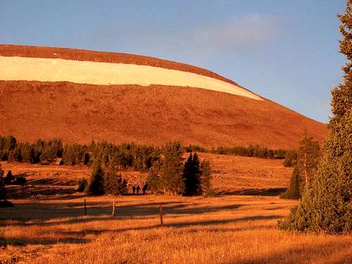 Sunrise on the upper east slopes of Leidy Peak.
Getting There
From near the center of Vernal along Highway 40, turn north at the sign for Maeser and follow the road north to 500 North. Turn west here and follow 500 North to 3500 West. Turn north here. There is a sign for Red Cloud Loop Road. Follow the Red Cloud Loop Road through Dry Canyon. If you have time, make sure to stop at the pictographs and petroglyphs along the way.The road becomes a good gravel road at the Forest Service boundary. Follow the Red Cloud Loop all the way to a major junction with the road to Hacking Lake. A sign points the way to Hacking Lake, and follow the road to near Hacking Lake. Instead of turning left at the lake, follow the main road right and to its end. This is the trailhead.
 Descending the west slopes of Leidy Peak. October 1, 2005.
Routes Overview
I have only climbed the peak from the North Ridge and east slopes, but since this is not a rugged mountain, Leidy Peak can be climbed from about every point on the compass. The only real obstacle is the snow/icefield on the northeast face.If you want some excitement, you could try climbing the northeast face via the snow/icefield directly. This would require an ice axe and crampons.
Two short routes are via the North Ridge or the East Ridge. The West Slopes is the easiest route on the mountain, though it is longer than most routes. The West Slopes route is the easiest route to the summit of a 12,000+ foot peak in the Uintas, and probably in Utah.
 Approaching the gentle northeast face of Leidy Peak. October 1, 2005.
The east ridge of the mountain looks like a good route and would be about 1.8 miles one way to the summit from the trailhead. The south part of the massif seems to have some loose talus, though the slopes to the east of this look easy. The northern part of the southwest face looks like an easy climb.
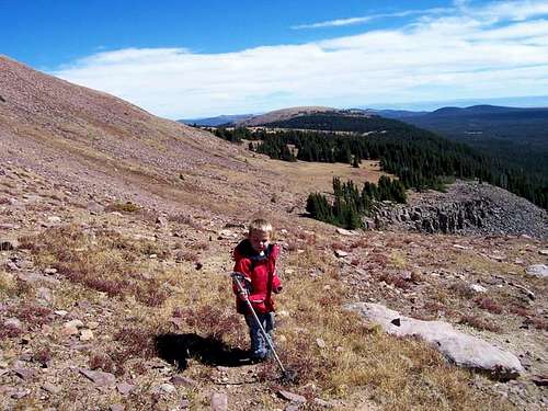 Approaching the east ridge of Leidy, after descending the west slopes. Photo taken on the south slopes looking east.
If you want a longer hike, there are several other routes available to approach the mountain. The peak can be climbed from Lakeshore Basin to the south. The trailhead has a bathroom, but the sign is missing. The trail must be fairly well used (?) because of all the fishing lakes. The trailhead is also on the Red Cloud Loop, same as the standard trailhead.
The peak can also be climbed from Ashley Twin Lakes. This would be a great route if you are thinking about climbing Marsh Peak on the same trip, but I am unfamiliar with the trail, or with its condition.
From the north, you could climb Leidy Peak from Browne Lake. Years ago, I hiked to Red Lake from there, but don’t remember much other than the trail is good, at least to Red Lake.
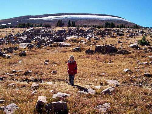
 Kessler wanted to try a direct route up the Leidy Icefield, but unfortunately, REI does not make crampons and ice axes for 3-year olds.
Red Tape
No permits are required. Normal wilderness rules apply.When To Climb
Mid-July through Mid-September is the normal hiking season. The roads in the area are usually open in late June or early July. They usually close when ever the first big snowstorm of the season hits, usually between mid-September and mid-October.While it is true that Leidy Peak is a short climb (half a day) in summer by Uinta standards, this is not true in winter. None of the roads in the area are open in winter. If you did try to climb this peak in winter, I would recommend taking at least ten days. Leidy Peak has probably never been climbed in winter, and it would be a real expedition.
 Summit of Leidy Peak looking south. October 1, 2005.
Camping
If you like camping with not many restrictions, and without the crowds, this is a good place to come.Dry Fork, on the road to the east trailhead has many nice campsites in the forest, some with picnic tables and fire places. All are free of charge! There are other campsites closer to the trailhead along the road, including near the trailhead.
There are many backcountry campsites as well, but since the peak can be done easily in a day, most people will do this as a day hike.
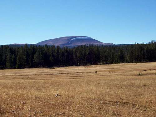 Leidy Peak from the east and from Trout Park (meadow). October 1, 2005. Many good campsites are around.
Mountain Conditions
Contact the ranger station in Kamas for current road and trail conditions. Their phone number is 801-783-4338.Weather Forecast for Central Uinta Mountains
Here are some average highs and lows from the 12,139 foot elevation (3700 meters) in the Uintas (about the same altitude as the summit):
| MONTH | HIGH | LOW |
| JAN | 14 | -1 |
| FEB | 16 | 1 |
| MAR | 19 | 4 |
| APR | 27 | 11 |
| MAY | 35 | 18 |
| JUN | 45 | 25 |
| JUL | 55 | 32 |
| AUG | 53 | 31 |
| SEP | 45 | 24 |
| OCT | 34 | 15 |
| NOV | 22 | 8 |
| DEC | 17 | 3 |