
-
 2795 Hits
-
 77.48% Score
-
 8 Votes
|
|
Mountain/Rock |
|---|---|
|
|
38.54000°N / 107.2986°W |
|
|
Gunnison |
|
|
Hiking |
|
|
Spring, Summer, Fall, Winter |
|
|
9300 ft / 2835 m |
|
|
Overview
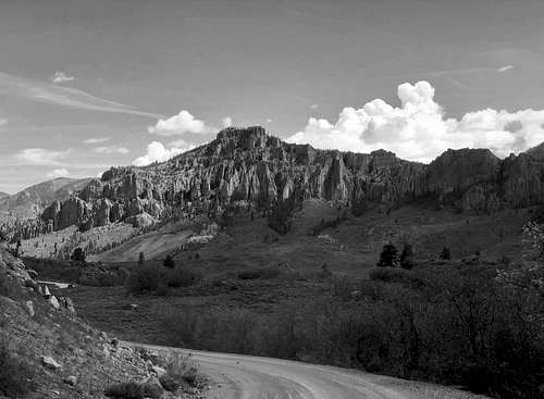 Pearson Point
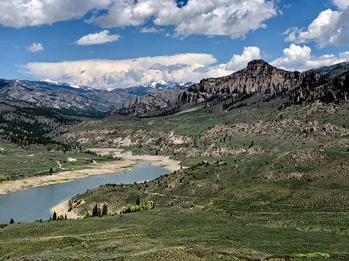 Pearson Point
The area around Blue Mesa reservoir has many small summit for hikes, and obviously there are many water based activities and great camping. Blue Mesa Reservoir was created by the construction of 390 foot tall dam and you will get to drive over this dam if you choose to hike Pearson Point. The area surrounding Blue Mesa Reservoir is part of Curecanti National Recreation Area, but Pearson Point is not.
Parent Lineage: Line Parent: Bonfisk Peak Proximate Parent: Soap Mesa
Class: 2
Wilderness: West Elk: is fifth largest wilderness area in Colorado and perhaps the least well known. There are scenic vistas of volcanic spires, towers and castle like formations. Long valleys and forests of aspen. The West Elk Wilderness is well suited for backpacking, unspoiled scenery and with NO fourteeners, freedom from crowds. (Colorado fourteeners became so popular that those trails on summer weekends are packed with hikers).
Colorado Rank: 2733
Getting There
Take highway 50 from Montrose or Gunnison and turn onto well signed road for North Rim of Black Canyon, Colorado State Highway 92. Cross the Blue Mesa Reservoir dam - worth to stop in and peak into the deep canyon with Gunnison River running towards Black Canyon National Park.
Continue for about 1 mile and turn right onto County Road 721, well signed Soap Mesa Road. This is a dirt road, but passable by low clearance 2 WD vehicles. Continue for 8 miles until you see signs for Soap Creek Campground. Right before entering campground is a nice parking for trail users.
Route
The route starts on a nice trail.
Distance: round trip 3.7 miles
Elevation Gain: 1536 feet (steep)
Difficulty: 2, possibly a few 2+ moves to gain the large summit block.
Red Tape
There are no fees for hiking. If you stay in developed campground, you have to pay a fee.
West Elk Wilderness rules apply.
When to Climb
Summer, spring and fall are obviously the easiest time since the road is open all the way to Soap Creek Campground. Winter - there is a road closusure depending on snow conditions. Typically, only the first part of the road is open since there are a few people who live there.
Camping
There is a nice campground right at the trailhead - Soap Creek Campground with vault toilets, tables and firepits. Another campground Ponderosa is near by and a little bit more close to Blue Mesa. Ponderosa Campground is part of Curecanti National Recreation Area. There are a few pull out along the Soap Mesa road where you can camp for free, but no facilities.