
-
 11907 Hits
-
 91.14% Score
-
 34 Votes
|
|
Area/Range |
|---|---|
|
|
38.46650°N / 107.16689°W |
|
|
Hiking, Trad Climbing, Ice Climbing, Scrambling |
|
|
Spring, Summer, Fall, Winter |
|
|
7100 ft / 2164 m |
|
|
Overview
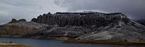
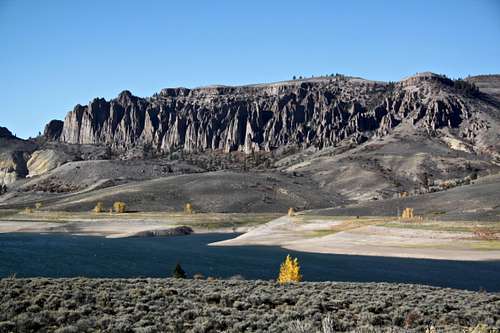 Dillon Pinnacles
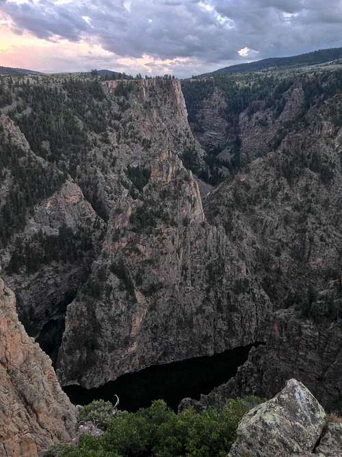 Sunset over Curecanti Needle
Curecanti National Recreation Area is a series of three reservoirs, along the once wild Gunnison River. The national recreation area borders Black Canyon of the Gunnison National Park on the west. The reservoirs that make up Curecanti today are a destination for water based recreation high in the Rocky Mountains. Best known for salmon and trout fishing, Curecanti also offers opportunities for hiking, boating, windsurfing, camping, climbing, and bird watching.
Reservoirs and Dams in Curecanti
Blue Mesa Reservoir is Colorado’s largest body of water. Created by Blue Mesa Dam. Blue Mesa Reservoir is 20 miles long (32 km), has 96 miles (154 km) of shoreline, and is the largest Lake Trout and Kokanee salmon fishery in the United States. Blue Mesa reservoir was completed in 1945.
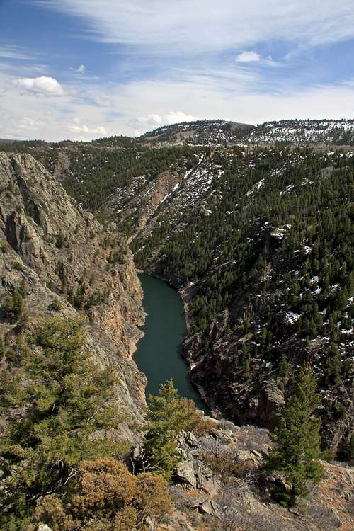
12 miles below Blue Mesa Dam is Morrow Point Dam. Morrow Point Dam was completed in 1967 creating Morrow Point reservoir. While the primary purpose of Blue Mesa Dam is to store water, the primary function of Morrow Point is to produce hydroelectricity.
Crystal Dam is a double curvature thin arch dam located six miles (10 km) downstream from Morrow Point Dam. Crystal Dam is the newest of the three dams in Curecanti, its construction was finished in 1976, forming Crystal Reservoir. Below Crystal Dam is the East Portal of the Gunnison Tunnel, a National Historic Civil Engineering landmark. Just below East portal is the eastern boundary of Black Canyon of the Gunnison National Park.
What does the name "Curecanti" mean? Curecanti National Recreation area is named after a Ute Indian sub-chief who roamed through eastern and souther Colorado from the 1860s to 1870s.
Getting There
 Curecanti National Recreation area
 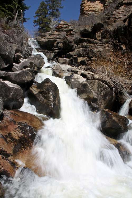 Curecanti stream.
 Map of Curecanti NRP from national park service - click here
U.S. Highway 50 runs the length of Curecanti between Montrose and Gunnison, Colorado. The recreation area is also accessed from CO Hwy 149 and CO Hwy 92.
Public Transportation: complicated, by bus or trail to Grand Junction, and then hitchhike
Plane: Commercial airline service available to Gunnison, Montrose, and Grand Junction. You can rent a car at the airport.
The area would be great to tour on bicycle (lots of hills) and the East Portal Road (paved) leading to the bottom of Black Canyon and Crystal Dam is one of the steepest roads t in Colorado. It has 16% grade.
Hikes in Curecanti
Curecanti is known more for its water based activities, uniformed hikers don't know that Curecanti National Recreation Area has many excellent places to hike, and one of my favorite hikes in the area (including Black Canyon and Gunnison Gorge) is below described Curecanti Creek Trail. You don't need to obtain a permit or pay a day-use fee to hike in Curecanti NRA, or to use several primitive campsites in the NRA (some accessible by trail, some by boat only).
Neversink Trail - The pretty Neversink Trail is popular with birders because of its proximity to a great blue heron rookery. This flat, easy to follow trail is wheelchair accessible, winding its way along the north bank of the Gunnison River through a riparian environment of the cottonwoods, willows, and wildflowers. There are benches to rest at along the way, perfect for observing the bird life. The river is sometimes wadeable, attracting fishermen and children intent on exploring around the pools and shallows. The trail leads east from the parking lot of the Neversink Picnic Area, 5 miles west of Gunnison off the south side of US-50. Pick up a Neversink Trail Guide at the parking area.
Length: 1.5 miles round trip, minimal elevation change
Cooper Ranch Trail - Less than 1.0 mile west on US-50 from the Neversink Picnic Area is another pretty spot along the river. The Cooper Ranch Trail begins in the parking lot of the picnic area with the same name. Once again, the river is often wadeable here and you can follow trails along either bank. The easy trail goes west, in and out of grooves of cottonwood, brush and grassy meadows. Eventually the nice trail peters out, but a fisherman's fainter trail continues along the river all the way to the shore of Blue Mesa Reservoir. The access road to the picnic area is closed in winter, but you can park at the gate closure and walk, ski or snow shoe in.
Length: 0.5 miles
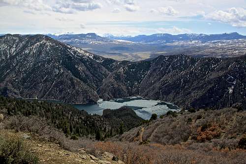
 Blue Mesa reservoir and Dillon Pinnacles
Dillon Pinnacles - The interesting Dillon Pinnacles Trail explores the contrast between the semi-arid landscape, with is weirdly eroded volcanic pinnacles, and Blue Mesa Reservoir. Drive west on US-50 for 21 miles from Gunnison and turn off into the parking lot at the north end of Middle Bridge, which spans the lake. Walk down toward the boat ramp and take a right turn onto the path. It follows the shore of the reservoir a short distance, then climbs through open sagebrush before dropping into Dillon Gulch. At a fork with a jeep track go left and, traversing below the pinnacles, reach a lookout point marked by a short loop. There are wonderful views of the lake, the distant San Juan Mountains and the pinnacles, with benches along the way and plagues that explain the geology. The rock is a conglomerate called breccia, formed by volcanic activity north in the West Elk Mountains, then carved by erosion into strange shaped hoodoos. For a longer and harder hike, go north up the jeep track in the gulch for about 1 mile steeply up to the top of the mesa for fantastic views.
Length: 4 miles round trip, 600 feet ascent.
Pine Creek Trail - this short, popular trail provides access to the Black Canyon below the Blue Mesa Dam for hikers, fisherman, boaters (hand carried craft only) and for those taking the ranger lead boat tour on Morrow Point Reservoir. The trail descends 180 feet into the canyon via 232 steps, following lovely cascading Pine Creek Trail as it cascades merrily down to the river. There's an overlook along the way with an upstream view of the nearly 400 foot tall face of Blue Mesa Dam, straddling the canyon's steep walls. The trail crosses the creek, then descends to the riverbank, where you stroll west along the old gauge railroad bed beside the river to the launch point for the boat tour. The path follows the route of the so called Denver and Rio Grande Western's "Scenic Line of the World" which plied through the eastern end of Black Canyon for nearly 70 years. Interpretive signs along the way explain the geology of the area. There are several picnic tables that offer shady resting spots. At times of low water, you may continue along the historic rail bed beyond the boat launch, to a point where it is submerged by the lake waters. To get to the trailhead for the Pine Creek Trail, head west on US-50 for 1 mile beyond its junction with CO-92. Turn right at the sign unto a steep road and follow it shortly to a small parking area.
Length: 2 miles round trip, 180 feet descend (55 meters) via steps.
Mesa Creek Trail - short, scenic hike below the Morrow Point Dam along the Gunnison River leading to Crystal Reservoir. The hike starts off Hwy 50, turn towards the Cimarron Visitor Center, vintage train exhibit, and campground, and drive to the end of the paved road. The railed overlook offers a view of the confluence of Cimarron Creek and the Gunnison River and the canyon downstream. To the south of the parking lot, railroad locomotive Number 278, along with a tender, boxcar, and caboose sit atop the last remaining piece of trestle. A memento of the railroad's heyday, it was one of the engines that pulled trains through the Black Canyon on the "Scenic Line of the World" until the line was closed in the 1940s. From the parking lot the dirt trail descends the slope to the river at an easy grade. If you choose, you can walk up a short distance toward the dam to get a good view of the hydroelectric generating plant. The trail crosses the river on a steel foot bridge and continues along the north side of the stream. A small shaded bench just over the bridge offers a genial resting place. The sheer walls and extreme narrowness of the Black Canyon are appreciated along this trail as views from the base of the Morrow Point Dam.
Length: 1.5 miles round trip
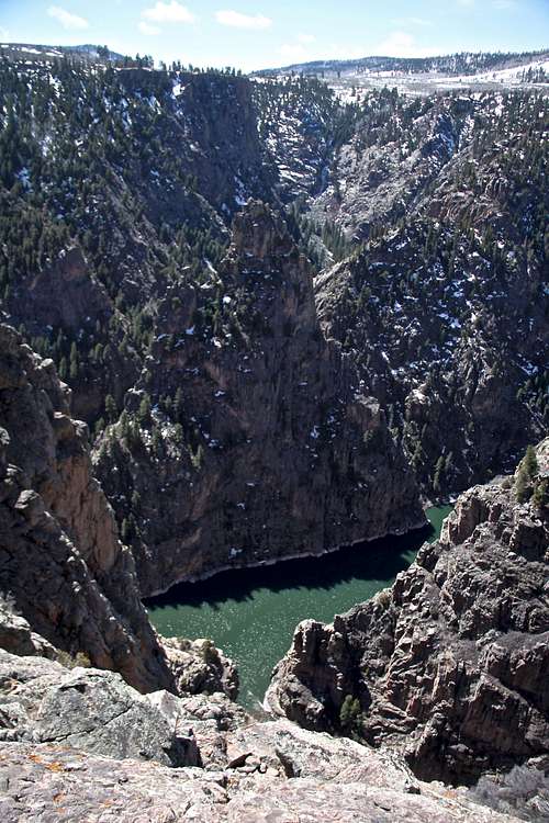
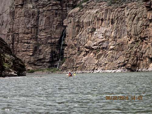
Curecanti Creek Trail - Lovely Curecanti Creek (my favorite hike in the area) rolls down to Morrow Point Reservoir, it could be made as an overnight trip not because of length or difficulty, but because of its beauty, amazing scenery and great camping down below. The trip takes about 2 hrs only, but the fine campsites at the bottom are asking you to stay overnight. It provides access to the famous Curecanti Needle, and this is on my wish list to come back back with a boat, get across the river and climb this landmark. The hike begins at the Pioneer Point Overlook, off CO-92, 5.7 miles west of its junction with US-50. Take a moment to check out the railed overlooks for one of the best views in Curecanti NRA. Your route descends the canyon to the west. Follow the sign from the parking lot, traversing northwest down through open pine and scrub forest. Once into the canyon alongside the cascading creek, the trail turn south and becomes steeper, descending through rock steps, and crossing the creek on two foot bridges. About half way down, there is a pretty picnic area set in a meadow with table and grill. The trail ends where the creek spills out into a small inlet on the reservoir. Nearby are a couple of tent sites with picnic tables, fire grates, bear safe container, and an outhouse. The sites are free - first come, first served. Across the inlet and the narrow lake, towers the 700 foot (210 meters) spire of the Curecanti Needle. Once famous as the marketing symbol for the Denver & Rio Grande rail line through the upper part of the Black Canyon, it's made up of Curecanti quartz monzonite, a light colored, fine grained granite.
Length: 4 miles round trip, elevation change 900 feet (270 m).
Hermit’s Rest Trail - this is the most strenuous hike in Curecanti NRA; but although rated difficult due to the elevation that must be regained on the return, the trail is of high standard with plenty of switchbacks to spread out the rise and with benches placed for resting. Bring lots of water - there's none along the trail and this south facing slope can get pretty warm when climbing out on a summer afternoon. Zigzagging through oak, pine, juniper, and fir, hikers descend to wooded camp and picnic sites on the shores of Morrow Point Reservoir. Campsites with picnic tables, fire grates and toilets are provided at the end of the trail. The trail starts off Hwy 92 at the National Park Service "Hermit's Rest" sign. The trail begins just beyond the picnic pavilion at the west end of the parking lot. Because this hike drops 1800 vertical feet over three miles, the going is steep. Switchbacks make the descend manageable and not extreme. When estimating your travel time, figure it will take you twice as long to ascend as descend. One and a half hours down and three hours up are average. Midway down you enter a pinyon forest, and the switchbacks become shorter and the descent steeper. Benches are placed to take advantage of shade and scenery (very convenient on your way up).
Length: 6 miles, elevation change: 1,800 feet (550 m)
 Nice view of San Juan mountain range from Hermit's Rest Overlook.
Crystal Creek Trail - Winding through abundant wildflowers, oak, aspens, conifers and a recovering burn area, Crystal creek trail is ideal for spring or fall hiking. Sweeping views of Cimarron Valley, the West Elks and San Juan Mountains can be viewed along the way. The trail ends at an overlook, 1,800 ft (550 m) above Crystal Reservoir. The trail starts at the turn off from Hwy 92, there is a sign for the trail at the parking lot. There is also an outhouse and picnic table. The trail is hard packed dirt most of the way with occassional rock fragments. It winds along the ridge, with switchbacks at steeper sections. Three evenly spaced wooden benches along the path make for comfortable rest stops to take in the majestic panoramas. The trail before the first overlook offers magnificent views of the Cimarron Valley, Poverty Mesa, Uncompahgre Peak, and the San Juan mountain range to the south. The second bench looks north to the West Elk mountain range with the peaks of Land's End, Lamborn, Saddle Mountain, and Cathedral Peak clearly visible from left to right (west to east)
Length: 5 miles round trip, elevation change 525 feet
Ice Climbing in Curecanti
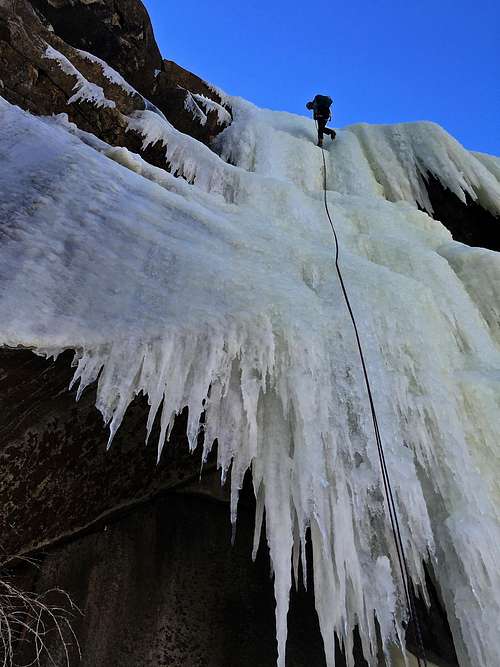 Rappelling the crux - Curecanti Monster
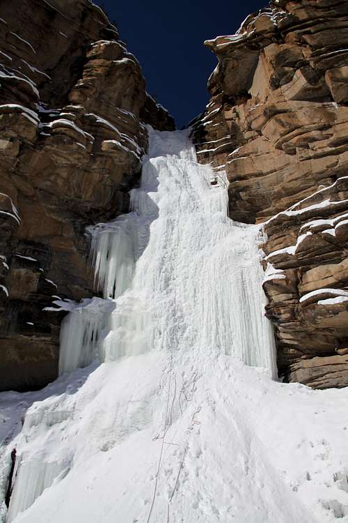 Chipeta Ice Falls
I have climbed Chipeta Falls, lovely outing and have explored some other ice climbs in the area as well - Train Route (mountain project calls it 278) and Curecanti Monster.
Chipeta Falls WI3- have its own SP page, so I will not go onto detailed description. This waterfall requires about 1 hr long approach, you come to the top of the waterfall and rappel down. There are bolts at the top, and you can even top rope the fall if not feeling comfortable with leading ice. The waterfall is wide, and you can find WI3 route, or make it more difficult and find some WI4 lines on it. It is 50 meters long. The area is very scenic. No mountain project description yet.
Curecanti Monster WI5, SP page for Curecanti Monster 300 meters long, and the most famous ice fall in the area. Drive on Hwy 50 to a small pullout (just before Alpine Plateau Rd.) Descend to Blue Creek. Cross the water and then ascend the steep hillside parallel to the power lines. As you crest the top of the hill, follow the power line for two poles, then follow the road when it leaves the power line in an easterly direction. Continue on this road, passing through a private parcel of land that is fenced off and is host to several cabins (Generally these remain vacant during the winter). This road is public so you aren't trespassing. You are roughly across from Pioneer Point Overlook. Stay on the road for about 30 min until you reach a small hill. Pass this on the left and descend into woods. This is the drainage that is at the top of the "Monster". Continue the descent until the trees open up and the ice appears. The first rappel is from the trees at the edge of the ice. Use V-threads for the remaining rappels to the bottom. Hike time: 2.5 to 4 hrs, including rappels. Climb: The Monster spans approximately 50 feet at its widest and is five 60 meter pitches long. Per Jack Roberts book this is the longest ice climb in Colorado. The first 2 piches are WI2-3, the 3rd pitch follows a series of WI4 steps to a sheltered belay. The 4th pitch is the crux and is WI5 for a full 50 meters. The last 2 pitches are WI3 and lead back to the first rappel from the trees.
Mountain Project description - rates is WI4.
Train Route WI4, A.K.A. 278 (or if you look it up on Mountain Project 268 - why so many names? well, Jack Roberts calls it in his Colorado Ice Train Route because it is located along the old Denver&Rio Grande Railroad. He has only 4 lines in his book about this climb. Jimmy Newberry did the first ascent and he called it by the name of the locomotive standing nearby 278, but when we asked him in his store (located only a couple of miles away) about this route, he told us 268. I think that Jimmy confused the numbers, the locomotive is 278. So, anyway, this is a nice little climb, which does not always come in. There is minimal approach (see one of the photos, basically you just park in front of it). Approach involves crossing Cimarron Creek. I would do it in 2 pitches, the start can be steep and thin. There are rappel anchors at the top. It is easy to get to, regular cars are fine on a paved road. Stop by the Newberry store to ask more details about it.
Mountain Project description - called 268 by mistake.
I have not explored other ice in the area, but there are many more ice falls. Some involve crossing private land to get to.
Rock Climbing
 Curecanti Needle
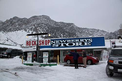 Jimmy Newberry is a pretty known Colorado climber (the guy in the blue jacket is him). His family lives in Cimarron and they own a little store and gas station. He established many routes in the Black Canyon.
 If you wish to get some more information about a local rock ask Jimmy Newberry at his family store in Cimarron. The store and gas station are worth visiting. Newberry family sells all sorts of curiosities (the gas station is the old style, no credit card slots) and they have photos of Jimmy and his climbs, including some impressive fish caught locally. The place is not visited often and they could benefit from your business. Again, there is so much rock around. I have in mind a couple of cracks I would like to try, but most of the area is a virgin rock. Climbers tend to head straight for the Black Canyon.
Curecanti Needle - is a distinct granite rock formation (more impressive when viewed from the bottom of the canyon). It rises steeply to a sharp point approximately 700 feet (210 m) above the canyon floor.
Mountain Project describes several routes, all involving a long approach, boat trip across the river, and the actual climb.
The photo to the left is taken from the Pioneer Point Overlook, which most people use for the approach. Curecanti Creek trail brings you to the bottom of the canyon, and you are at the base of the Needle, with about 200 meters of super cold water between you and its base. You can also boat in from Pine Creek, which would be a couple of miles on the water. Some mention to attempt this in the winter, when the water is frozen, but climbing 5.9 in snow/ice could be a challenge.
Boating
 Pine Creek trail - imagine carrying your boat here
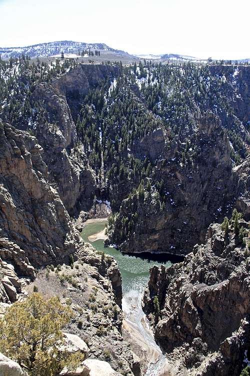 Morrow Point Reservoir scenery
Blue Mesa Reservoir - is surrounded by sage covered hills and unique rock formations. The views are wide and expansive and the shoreline sand, gravel, driftwood. A permit is required for all motorized craft. It is the largest body of water in Colorado. Wind can create big waves. There are several marinas - please look Curecanti NRA for more information.
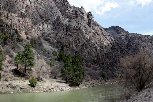
Morrow Point Reservoir - has a different feel, narrow and steep walled canyon between Blue Mesa Dam and Morrow Point Dam. It is more remote, quiet, and the scenery is spectacular. The rock walls come straight down to the water for long stretches. If you capsize, you may have to swim a good distance before you can get out of the water. The water is cold (40-50 degrees F). No permit is required.
The access is more of a problem, you have to carry your boat in. The shortest approach would be at Pine Creek Trail.
A pontoon boat tour of Morrow Point Reservoir is available daily Memorial Day through Labor Day. The tour is lead by Park ranger, and takes you past Chipeta Falls, past Curecanti Needle, and tells you the story of the narrow gauge railroad that once ran through the canyon.
Up to 22 miles round trip.
Crystal Reservoir - again non-motorized boats only, between the Morrow Point and Crystal Dams. This reservoir has incredibly rugged scenery, with spectacular jagged spires, massive buttresses, fantastic formations, and towering cliffs on either side. It is quiet and remote. Again, if you capsize, expect swimming some distance before reaching a shore and a very cold water. The best access is from Cimarron Mesa Creek trail. Morrow Point Dam generates hydroelectric power for a grid system that sends electricity throughout the western states. The controls that fire the turbines and open the dam's flood gates are located at Glen Canyon Dam in Arizona. That means, if you are a boater trying to launch below the dam, you may get caught in water released any time the grid need the power. A big release turn the river below the dam into a pushy whitewater for close to a mile.
Up to 13 miles round trip.
 Chipeta Falls
Red Tape
 East Portal road is a steep 16% grade road, which takes you all the way down to the river.
 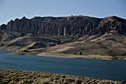 Dillon Pinnacles and Blue Mesa Reservoir
Curecanti NRA is open year round. Pets friendly.
Curecanti NRA is spread over a large area and receives many visitors (nearly 900,000 per year) that there are several visitor and information centers.
The Elk Creek Visitor Center, 16 miles west of Gunnison on US-50, is the primary center, as well as the headquarters for the National Park Service. It's open mid May through late September, and open on weekends during the rest of the year. You can ask rangers about boating and fishing conditions and obtain the necessary boating permit for Blue Mesa Reservoir.
The Lake Fork Information Center is located 25 miles west of Gunnison on CO-92, just north of its junction with US-50. Lake Fork is only open from mid Ma to late September. You'll find a ranger on duty and a small retail outlets where books, maps, postcards are sold.
Cimarron Information Center is further west along US-50, 35 miles from Gunnison. It is open summers only. This is a must stop for railroad buffs who will be interested in the photo exhibit about the days when the Denver and Rio Grande Western Railroad high-balled through the canyon.
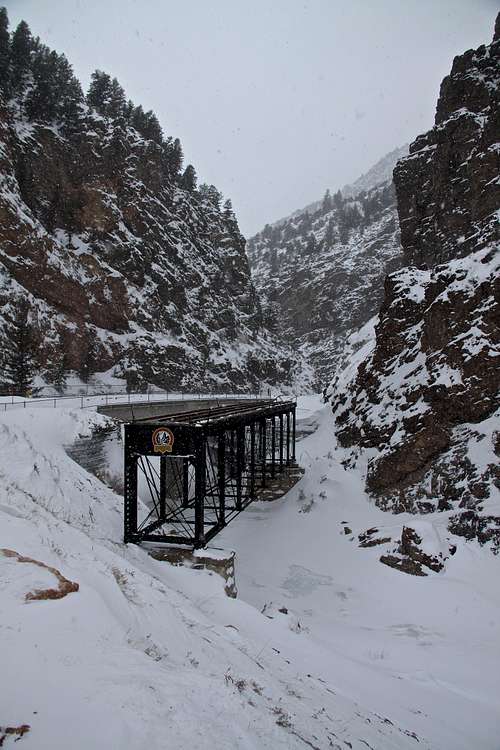
East Portal accessed just past the entrance to Black Canyon of the Gunnison National Park requires a fee as mentioned above. The road is paved, but closed during the winter. It is very steep, winding road (16% grade). There is an information station at the bottom with info about both Curecanti NRA and the National Park.
Ranger Programs
- Morrow Point Boat Tour: Join a park ranger for a leisurely boat ride along the Morrow Point Reservoir. Tours operate twice daily, except Tuesdays, late May through early September (Memorial Day to Labor Day), at 10:00 am and 12:30 pm. Non-refundable, prepaid reservations are required. Call for reservations (970) 641-2337, ext. 205 or stop by the Elk Visitor Center (15 miles west of Gunnison off Hwy 50) to make reservations. Walk ons are not permitted. Fee: adult 16$, children under 12 8$, seniors 8$. Photos from Morrow Point Boat tour here
- Night Hike: Enjoy the spectacular stargazing at Curecanti by joining a night hike. Location and dates may vary to take advantage of full moons and dark skies. Free reservations are required. Again, call Elk Creek Visitor Center (same number and extension as above).
- Other Ranger Programs: A variety for all ages, including Junior Ranger activities, are offered throughout the summer season.
Historic Denver & Rio Grande Western Railroad
 Denver & Rio Grande Narrow Gauge Trestle
 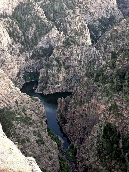 Evening light on Curecanti Needle
The Denver & Rio Grande Western Railroad was a U.S. railroad company. The railroad started as a narrow gauge line running south from Denver, Colorado in 1870. It served mainly as a transcontinental bridge line between Denver and Salt Lake City. The motto was Through the Rockies, not around them. (Narrow gauge was cheeper when compared to standard gauge)
More history here on wiki page and even more if you visit the information center at Cimarron (fascinating stories from the past).
When the first Denver and Rio Grande train passed through the upper reaches of the Black Canyon of the Gunnison in August 1882, the passengers gazed with wonders at the steep walls above them, the cascading waterfalls and the towering granite point of Curecanti Needle. As the little train found its way out of the canyon and the passengers set their thoughts toward the open vistas ahead, few could imagine the human and monetary cost of constructing this "Scenic Line of the World" through some of the most rugged country in the West.
General Palmer wanted originally to travel the entire 53 mile length and depth of the canyon, but his surveyors convinced him that 15 miles of railroad through the Black is quiet enough. Construction of the 15 miles of Denver & Rio Grande Narrow Gauge Railroad through the Black Canyon continued throughout the winter of 1881-82. Carving a railroad bed from the steep, rugged and extremely hard rock wall made some of the most difficult and hazardous work. A crew was using an unfamiliar explosive nitroglycerine and several people died using it. More than 1000 men picked and shoveled away in the canyon. These hardy, underpaid men, mostly Irish and Italian Immigrants, braved unbelievable working conditions. After the line was completed through the canyon, in 1882, the route remained dangerous and in need of constant maintenance. Thanks to the efforts of the dedicated men who built and maintained this route, thousands of people and tons of goods and livestock were afforded safe journeys past this famous landmark and early symbol of the Denver & Rio Grande - the Currecanti Needle.
According to Rudyard Kipling, who rode through the canyon in 1889:"We entered a gorge, remote from the sun, where the rocks were two thousand feet sheer, and where a rock splintered river roared and howled ten feet below a track which seemed to have been built on the simple principle of dropping miscellaneous dirt into the river and pinning a few rails a-top. There was a glory and a wonder and a mystery about the mad ride, which I felt keenly... until I had to offer prayers for the safety of the train."
The engineers that took trains through the canyon for the next 67 years may have agreed to the beauty of the canyon, but were extremely fearful of the route - especially during the winter. Avalanches and rock falls were common. The decrease in mining activity, the increase of standard gauge routes trough the Rockies, and the rising use of automobiles and trucks led to the gradual demise of narrow gauge railroads.
External Links
Curecanti National Recreation AreaCamping
 nice and secluded camping areas
 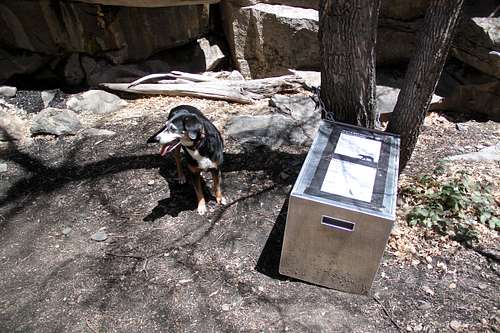 Bear proof containers at campsites.
The park website has detailed information - link here. Click for weather forecast
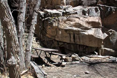
I would prefer remote and primitive backcountry camping located along the trails and at the bottom of the canyon. The sites look very inviting with fire pits, vault toilets, bear proof containers, picnic table etc. There is no reservation for these types of camp sites - first come, first serve basis.
Backcountry camping is for free.