

-
 10669 Hits
-
 75.59% Score
-
 6 Votes
|
|
Area/Range |
|---|---|
|
|
42.39659°N / 2.15469°E |
|
|
Hiking, Mountaineering, Trad Climbing, Skiing |
|
|
Spring, Summer, Fall, Winter |
|
|
9547 ft / 2910 m |
|
|
Overview
Puigmal (2,910m), also called Puigmal d'Er, is a mountain in the Pyrenees, on the Spanish-French border, and it's one of the higher mountains in Catalonia and Eastern Pyrenees.This area is really small, but it's difficult to include in Cerdanya or Canigó because is at south of the main line of the range and for this reason you can find some maps in 1:25.000 about the area.
Vall de Núria is a ski resort located in the Núria valley, in Catalonia (Spain). The ski area extends from 1,964 to 2,252 meters. The resort has a total of ten alpine ski trails (three green, three blue, two red and two black) and a special track for sleds. In total, seven kilometers of marked trails.
1. Puigmal
Massif of Puigmal

Puigmal

P.de Segre

Torre d'Eina

Finestrelles
Peaks of West side:
- Tossa del Pas de Lladrés (2,665m)
- Puigmal or Puigmal d'Er (2,910m)
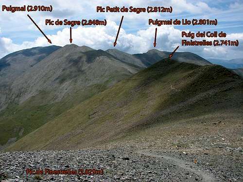
- Puigmal de Llo (2,801m)
- Pic de Segre (2,848m)
- Pic de Finestrelles (2,829m)
- Torre d'Eina (2,850m)
- Pic de Noufonts (2,861m)
- Cambradase (2,750m)
- Torre d'en Xillèn (2,680m)
- Pics de la Conca (2,722m)
- Roc del Boc (2,774m)
Peaks of East side
- Pic de Noucreus (2,799m)
- Pic de l'Infern (2,869m)
- Pic de Bastiments (2,883m)
- Gra de Fajol (2,708m)
- Balandrau (2,585m)
Trailheads:
The trailhead most frequented is the sanctuary of Nuria (1,960m) with access by train from Ribes de Freser or Queralps, but you have routes from Queralbs (1,220m) or Collada de Fontalba (2,074m) if you don't want to pay the train.
The peaks of East side has a very good trailhead in the ski-resort of Vallter 2000 or villages as Tregurà de Dalt.
2. Costabona
It's an important but small massif at East of Puigmal near of the ski-resort of Vallter 2000.Peaks
- Roca Colom (2,510m)
- Costabona (2,465m)
At N.E. of this small massif is the big Canigó (2,784m) in a new area of Pyrenees.
3. Garrotxa
Around the village of Olot.Peaks
- Comanegra (1,561m)
- Sant Marc (1,327m)
- Puigsacalm (1,514m)
- Puig de Bassegoda (1,373m)
- Puig del Mont (1,124m)
Getting There
Good road and rail (Renfe) communications. Vehicle access to Vall de Núria itself is not permitted; access is by means of the rack railway which takes you into Vall de Núria. For this purpose there are convenient free car parks available at the train stations Ribes Enllaç, Ribes-Vila and Queralbs.see bigger map
Travel time
Barcelona: 1h 30m
Girona: 1h 30m
Lleida: 2 h
Tarragona: 2h 20m
Zaragoza: 3h 15m
Valencia: 5h
Madrid: 5h
Bilbao: 6h 30m
Andorra: 1h 45m
Perpingnan: 2h 30m
Toulouse: 2h 30m
External Links
valldenuria.catwebcam Nuria