
-
 13463 Hits
-
 83.1% Score
-
 16 Votes
|
|
Area/Range |
|---|---|
|
|
42.29390°N / 0.2366°W |
|
|
Hiking, Trad Climbing, Sport Climbing, Toprope, Bouldering, Via Ferrata, Canyoneering |
|
|
Spring, Summer, Fall, Winter |
|
|
6814 ft / 2077 m |
|
|
Overview
At South of the Pyrenees some mountains rise, highly individualized, an unordered set of massifs marking the transition between the mountains and the great depression of the river Ebro is the so-called sierras exteriorres (outer mountains), reaching altitudes, of course, smaller than the axial chain although in all cases are important enough to highlight in the region in which they appear. We are referring to the peaks of Santo Domingo, San Juan de la Peña, Riglos, Loarre and Guara.
Also included here, the Sierra de Sis/Ribagorza area (Ríos Isábena y Noguera Ribagorzana), or Sierras Interiores (inner mountains), see also Pyrenees-Benasque.

Peñas de Sto.Domingo
The pre-Pyrenean sierras of Aragón are N or NW, (or in the case of Sierra de Sis, NE) of Huesca, the capital city of the province of Huesca and the Hoya de Huesca basin. The region of Aragón comprises the provinces of Huesca, Zaragoza, & Teruel, with Huesca the most northern of the three. The most "important" area are: Jaca - Sierra de Guara - Riglos - Sierras de Loarre & Gratal (Sierras Exteriores) and Sierra de Sis/Ribagorza (Sierras Interiores). Away from Huesca & Jaca the area is dotted with small villages & hamlets, many of them abandonned, but a rural life still very much exists here.
GEMS OF THIS AREA: Apart from the rock climbing at the internationally reknown Mallos de Riglos, the Sierra de Guara Natural Park is one of the best places for canyoning "in Spain, if not Europe" (quote from "The Rough Guide to Spain"). The Rodellar & Vadiello areas have some superb sport-climbing and there are even a few via ferrata/protected routes. Ascents of the high points Tozal de Guara & El Turbon are more than simple hikes, especially in winter, while elsewhere there is easy, un-crowded hiking on a network of local footpaths and quite an extensive network of BTT trails, with nearly always the fine backdrop of the big Pyrenean peaks some 150km further north. Other delights include important cave-paintings around Alquézar, hermitages, castles & historic fortresses and many local festivals and fiestas.

Ravine of Onsella
MAP BY VISENTIN. Click on areas.
Afficher
Getting There

Protected park areas in Aragón.
AIRPORTS: Reus/Zaragoza/Barcelona/Madrid.
TRAIN: The high-speed (AVE) train services link Huesca with Madrid.
In the skiing season, Huesca's small Monflorite Airport has flights from other parts of Spain (& in 2010, from London)
COACH: As a general guide, Barcleona-Huesca: 4h 20m. Huesca-Zaragoza: 1h. Jaca–Madrid: 3h. Jaca–Huesca: 1h
BY ROAD: Mostly good road links. See below for detailed information in "Getting around".
For information for Sierra de Sis, see El Turbón.
1.Peñas de Santo Domingo

Peña Oroel

Cuculo.
It's an isolated but nice place with a landscape very special with a lot of aiguilles and peaks in crackeds ridges. As curiosity the area is in the province of Zaragoza, just between Navarra and Huesca but geographically is a continuation of the same line of small ranges of Pre-Pyrenees.
The highest and most popular peak is Peña de Santo Domingo (1,525m) but you have another peaks in the Sierra de Luesia as Puy Moné (1,302m), Punta del Cabo Bal (1,312m) or Balsiruela (1,250m).
2.Jacetania

San Salvador.

Tozal de Guara

Torre de Santiago - Mascún
The most important town in this area is Jaca (406,3km2, altitude 818m). South of Jaca the "massif" of Peña Oroel (1,783m), is visible from many points of the city. A wonderfull lookout point for the Pyreneann peaks to the north, especially those of the Canfranc area.
North of Jaca exist some smaller peaks around the Collarada massif (2,885m) and the area of Canfranc, such as Pietrola (1,465m) and Grosín (1,422m).
South-West of Jaca is the San Juan de la Peña range with the peaks of San Salvador (1,547m) and Cuculo (1,549m). The Monastery of San Juan de la Peña built into the rocks on the north face is of major cultural interest.
 Riglos by V.Podachnik Riglos by V.Podachnik |
To the West the most important town is Sabiñanigo, South of the Tena Valley, with important mountains as Oturia (1,920m), with the famous route of the hermitages and caves.
3. Sierra de Guara
"Carnaval"
The Sierra de Guara is in the El Parque Natural de la Sierra Y Canyones de Guara made up of a central protected area of 47,450 hectares with a perimiter zone of 33,775 hectares, and declared a natural park in 1990. An area for rock (sport & some trad) climbing, canyoning, caving and easy to strenuous hiking that is also of great interest for its flora, fauna and geology. The highest and emblematic point of the Sierra de Guara is the Tozal de Guara (2,077m).
Erosion has created deep canyones, ravines, gorges, waterfalls, caves and narrow passes in this mainly limestone and "pudding" rock environment. The climate is cold and dry in winter, moderate with frequent rainfall in spring and autumn, and dry and hot in summer. The main summits can be snow-covered during much of the winter. The northern slopes are dominated by low, rough vegetation over a large area with wild pine, black pine, fir and beech forests. The southern slopes are Mediterranean forest and sierra, with the "encina" & box predominating together with wild pine.

"El Puro"

"El Puro" II
Despite these treasures, it's an area that is not hugely visited and can seem remote and wild. Acccess from La Tejeria/Santa Cilia (south), Nocito (north), Rodellar (east) and even Salto de Roldán (south) all involve a fairly long drive-in on minor roads.
Somontano de Barbastro. Area borded by the Cinca anad Alcanadre rivers, the north of this area sits on the eastern edge of the Guara park. The village of Alquezar is an impressive Medieval town with a former Arabic fortress. Also falling within The Parque del Rio Vero the town houses a new albergue y climbing wall (Rocodromo) and is, along with Rodellar & the Mascún Canyon, one of the main centres in the area for sporting activities such as canyoning and sport climbing.

Mallos de Riglos

The typcial terrain of this area is low sierra interspersed with (semi)-abandonned villages with a network of short-distance footpath routes or PR-HU trails,or "pequeño recorrido" routes, mostly well-marked (yellow-white markings) and signposted.
Rock (sport) Climbing: at Rodellar / Mascún Canyon / Guara / Bierge.
Via Ferratas/(protected routes): Bierge / Rodellar (Mascún) / Vadiello. These routes require experience and the correct "via ferrata equipment including harness, ferrata shock-absorber, rope & helmet.
Barranquismo / Canyoning: For the uninitiated, this involves descending wet or dry canyons with the use of ropes, harness, helmet and neopreno suits. A serious sport that should only be undertaken by the experienced and suitably equipped. Even if you have experience of this sport in other areas, its vital to be well-informed about a particular area before taking on any descent. Many companies in the areas around Alquezar & Rodellar offer guided excursions and training, as well as hire of equipment.
4. Mallos de Riglos
El Reino de Los Mallos - Kingdom of "the Mallos" - is probably best known for the rock climbing at the impressive Mallos de Riglos. A "mallo" is a pinacle or rock outcrop and these conglomerate rock formations have been attracting climbers since before 1929, with around 170 routes on 11 crags. Routes of all grades, though the majority are long, difficult, and/or mulit-pitch requiring experience and ability. There is also some interest here for hikers, while ornitholgists come here for the important colonies of birds of prey, especially the buitre leonardo (griffin vulture).
There are also a couple of via ferratas at Riglos & Ruaba - though in December 2010 this ferrata had been closed, possibly only temporarily, to protect wildlife/nesting birds. The main villages for this area are: Riglos (centre for access to the climbing area of the Mallos de Riglos), Ayerbe, Carcavilla, Murillo de Gallego, and Satna Eulalia de Gallego.
Try a virtual visit on the Mallo Visera or CLICK below on "Carnaval" & "El Puro" II for a 360º panorama (requires "Quicktime" player).
 On El Turbon. Photo: Visentin On El Turbon. Photo: Visentin |  Sierra de Sis. Sierra de Sis. |  Griffin Vulture (foto: Diego Sahagún). Griffin Vulture (foto: Diego Sahagún). |  Alquezar Alquezar |  On the route from Yebra to Oturia. On the route from Yebra to Oturia. |
5. Sierras de Loarre & Gratal
The most "important" mountain here is Pico Gratal, 1,574m an impressive rock outcrop, clearly visible from the south. Other summits are less "important" but have their own delights for easy hikes and excursions. These include: Pusilibro (1,597m) above Loarre Castle & Pico de la Calma (1,584m).Towns: Ayerbe, Loarre, Santa Engracia, Aniés. The village of Loarre is famous for its wonderfull 11th century castle/fortress, probably the main tourist attraction of the area. The Castillo de Loarre has appeared in many films about Middle Earth and the Crusades, in particular the recent Ridley Scott epic "Kingdom of Heaven".
 Griffin Vulture (foto: Diego Sahagún). Griffin Vulture (foto: Diego Sahagún). | 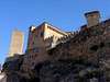 Alquezar Alquezar |
On El Turbon. Photo: Visentin |  On the route from Yebra to Oturia. On the route from Yebra to Oturia. | [img:694877:aligncenter:thumb:Barranco Artícas,Bolea.] |
6. Sierra de Sis/Ribagorça
Griffin Vulture (foto: Diego Sahagún).
& Sierra de Guara (r).]
To the east, also known as "Sierras Interiores" of the Aragonese Pyrenees, see also Pyrenees-Benasque. These sierras are on the far eastern edge of Aragón, close to the Llerida border. Main summit here is the magestic El Turbon, (2,497m). See link for more details, access etc. Even further east, lies L'Aumurriado' (1,790m), highest point in the Sierra de Sis. This area is characterised by wide, open slopes interspersed with dramatic rock outcrops. Major towns: Bonansa, Pont de Suert, Castejón de Sos and Las Paúles.
|
Alquezar |
On the route from Yebra to Oturia. | [img:694874:aligncenter:small:Eastern area. (Vall de Bellasia).] |
Salto de Roldán
[img:675422:alignleft:small:Salto de Roldán from]
* * The Salto de Roldán, 1,124m: Could be the emblem of the city of Huesca. Two conglomerate rock outcrops, significant landmarks seen from the city. Mirroring the structures found further west in Riglos, these two “mallos” - Peña San Miguel 1,123m) and Peña Aman/Man (1,124m) - are often considered the gateway to the Sierra de Guara Park from the Hoya de Huesca basin, situated as they are on the extreme south of the park. Between the two flows the River Flumen.
* * Salto means "jump". And Roldán? Roldán (Roland or Orlando) was a commander during the reign of Charlemange (his uncle) who died at the Battle of Roncesvalles at the hands of the Vascones* in the year 778. Legend has it that, fleeing from his enemy, Roland was surrounded as he reached Peña Aman. In a bid to escape he mounted his horse and made a wild jump (salto) to the opposite Peña Miguel, leaving his prints in the rock. * Possibly early Basque Country people. Both Peñas can be climbed. Peña Miguel is a hands-on scramble with the help of three short "protected" sections of metal ladders and "clavejas" or pegs. Peña Aman has just 5 very old pegs to surmount a near-vertical wall at the very top, which require much more effort to ascend and is only for the experienced.
Red Tape & Maps
[img:694539:alignleft:thumb:Typical sign in Guara.]The Sierra de Guara is a natural park area and there are restriction on climbing, caving and canyoning as well as camping. For hiking and ascensions of the Tozal de Guara, general park regulations exist. In particular, no camping, no fires
(In Summer the area is tinder-dry and the danger of forest fires is extremely high).
The small climbing areas usually have individual restrictions during nesting seasons. For more information on these, contact:
BOOKS AND MAPS: The Rough Guide to Spain has a short section on Aragón.
Maps: Alpina 1:40.000 Sierra de Guara 11.
The PRAMES Series Mapa Excursionista 1:40.000 Prepirineo/Pirineo
Aragonés covers the following area:
No. 7 San Juan de la Peña
Nos. 14 & 15. Sierra y Cañones de Guara I & II
No. 16. Somontano de Barbastro (for Alquézar area)
No. 13. Reino de los Mallos (for Riglos)
A new edition (2010): Sierra de Guara. Edition Sua.
Colección: CUADERNOS PIRENAICOS. With GPS co-ordinates and maps. (In Spanish). ISBN: 978-84-8216-393-2.
Fiestas.
[img:694537:alignleft:thumb:Dance Festival in Jaca.]Aragón like any other Spanish province has a full calendar of fiests throughout the year. The following could affect availability of accommodation in the area.
HUESCA: Though mid-summer is not the best time of year to visit Huesca for hiking or sport activities because of the high summer temperatures, you may want to bear in mind that the main week-long fiesta in early August each year is San Lorenzo (patron saint).
JACA: Late June/early July. Internatinoal Folklore Festival of the Pyrennes. This alternates anually with France with Jaca hosting in the odd-numbered years. Dance & music from all over the world.
Flora & Fauna (in brief)
[img:377478:alignleft:small:Griffin Vulture (foto: Diego Sahagún).][img:675415:alignright:small:Griffin Vulture on Peña Aman.]The rocky cliffs and pinacles of Riglos, Mascún etc attract eagles, egyptian vultures (alimoche) and the griffin vulture (buitre leonardo) and the rare Lammergeier or bearded vulture (quebrantahuesos in Spanish, literally bone breaker. Mammals include wildboar, fox & mountain cat. In the rivers, trout & the tritón pirenaico.
In the Guara park in particular there is a distinct contrast between Mediterranean flora on the southern slopes - with the “encinar” predominating while N we can find alpine flora with Quercus faginea or Portuguese Oak and beech forests. One of the best-preserved and southern- most beech forest in Aragón can be found on the northern slopes of Monte Peiró north of the Sierra de Gratal.
Getting Around
Good access by road for main towns but for small villages the minor roads (especially in poor weather) can make journeys longer than expected. [img:47318:alignleft:thumb:Alquezar]Huesca - Jaca: 70km (1 hour by road) from Huesca. The N-330 N towards Sabiñanigo which then becomes the A-23 at Cartirana, heading NW to Jaca.
You could also take the train from Huesca which is a very scenic route in itself if you have time to spare. However, not many trains run each day).
Huesca - Riglos (Mallos de Riglos): 42km (40m by road) on the A-132. After passing Ayerbe, take a turning right onto the HU 310 to Riglos village). You can take the train as mentioned above. Check that you notify the driver you want to get off at Riglos, as it doesn't automatically stop. Ask for Riglos-Consilio. This is also important if you want to take the train to return to Huesca! The service is very infrequent. Huesca - Loarre: The A-132 to Ayerbe and A-1206 to Loarre.[img:693725:alignleft:thumb:Guara from SE]
Main access points for the SIERRA DE GUARA:
South: La Tejería or Santa Cicila*. 40m by road. N.240 direction Monzon. The A-22 and then the HU-V-331. * Take care: There is also a Santa Cicilia in Jaca!
East: Rodellar/Mascún, in the centre of the park: 1h 14m. N-240 - A22 - HU 341. via Abiego, Bierge. Warning: in busy climbing season, it is not possible to park in the village. Look for the parking area to the left as approaching the village.
North: Nocito. N-330 N. At Arguis, a minor road via Belsué which borders the north of the park. 1h+ (49km, partly on minor road which could be difficult in poor weather conditions).
West: Salto de Roldán. H-324 to Apiés. HU-V-3241 to Santa Eulalia de la Peña. Don't turn into the village but continue up to the Peña San Miguel/end of the road. From here a track (1h) to Embalse Zingfuens. Vadiello: 23km. (30m on minor roads). N-240 east. HU-330 N via Loporzano, La Almunia de Romeral.
Accommodation & Camping
[img:505449:alignleft:thumb:On the route from Yebra to Oturia.]CAMPING
Alquézar: Rio Vero, Alquezar
Rodellar: Mascún, El Puente
Yaso: Altaoja Guara.
Panzano: Cañones de Guara y Formiga.
Huesca: San Jorge
Jaca Camping Aín (Note: Camping Peña Oroel/Jaca is not in operation, despite info on the 'net.
ALBERGUES/HOSTALS
Alquézar: Albergue Rural de Guara
Rodellar: Las Almunias.
External Links.
JACAPeña Oroel: images and text (spanish) about this peak.
Cuculo: images and text (spanish) about this peak.
San Salvador: images and text (Spanish) about this peak.
GUARA:
Pirineo.com: Guara (Spanish)
La Fueva: village with some routes about Guara on the page (Spanish).
Consumer: Parque Natural de Guara: information about the park (Spanish).
Gobierno de Aragón (Spanish)
Spain.info: Guara
RIGLOS:
cai Aragón: some information about Riglos (Spanish).
gdargaud.net some rock-climbs (English)
malditoduende: a few of routes of rock-climbing (Spanish).
revistaiberica: route quebrantahuesos (Spanish)
LOARRE
visentin - Mar 12, 2009 9:22 am - Voted 10/10
"Pre-Pirineos"I would rather translate it into english, but besides, I don't find this term very convenient. Pre-Pyrenees can be on both sides. Why dont' you name it simply "Huesca" ?
Rafa Bartolome - Mar 13, 2009 11:32 am - Hasn't voted
Re:yes, really pre-Pyrenees exist in a lot of parts in both sides of the range but the most important books call this area Pre pirineos of Huesca, it's a term according with the texts as for example "Pirineos 1000 ascensiones" from Miguel Angulo, the Bible of Pyrenees. The reason of the name Pre-Pirineos is the location of some important ranges in this zona specially the Sierra de Guara. It's not exist a range like this in all the Pre-Pyrenees on both sides, but I writed Huesca to identificate the area because it's true that exist a lot of Pre-Pirineos. If you write only Huesca you must include the South Part of Huesca and this area don't have any interest, only the Pre-Pirineos are interesting with nice peaks and beautifull images of nearby Pyrenees, and the North part (Pyrenees). The North part of Huesca is including in every area as Canfranc, tena, Ordesa, Benasque.... it's not a good idea to repeat. All the people in the North of Spain known the term Pre-Pirineos de Huesca, but why?... I don´t know, I only climb mountains, I think is a term only to clasifie these mountains in a chapter probably and don't write Riglos-Guara-Loarre ranges. Why the people don't call Montserrat and Montseny the Pre-Pirineos of Catalonya?... I dont't know, it's only the use of words for the people for years. The chapter of books about the pre-pirineos of my province (Navarra) call this mountains "the Navarre watchtowers of South of Pyrenees", it's only the need of a title, really is not very important, it's a excuse to write about some mountains that's not located in Pyrenees at 100% in some books and webs about Pyrenees. Do you understand me? (my english is not very good but I try to learn)
visentin - Mar 13, 2009 12:04 pm - Voted 10/10
Re: Re:I do understand you, if you say that this expression is common from the spannish point of view it's OK, but we should always keep in mind that the Pyrenees lie on 2 countries, not only the one from which we describe the mountains... I browsed from time to time the pages about the Pyrenees and there are too many spannish titles in my opinion... Same with the polish who write slovak peaks names in polish orthograph only, and so on..
Rafa Bartolome - Mar 15, 2009 5:53 pm - Hasn't voted
Re: Re:It's normal, 99% of pages of Pyrenees on SP has a Spanish writer, if you kwon French people to join to summitpost to write pages I'll be happy with it, but all my maps and books are in Spanish and I'm Spanish and for this reason a lot of mountains of SP are in Spanish side of Pyrenees and appear with the Spanish name. The people that write me demanding information normally are Europeans (not French) and Spanish. I don't know the reason but the French mountaineers don't write pages about their side of the range. I try to keep the original name and not the translation name. In the border mountains I use normally the most popular name, for example Le Taillon appear with the name Punta Negra in a lot of Spanish maps but all the mountaineers of both sides call "Taillon" this peak. Another examples of mountains that I don't write the Spanish name: Balaitous (Pico Moros in Spanish maps) or Pallas (Palas in Spanish), Vignemale (Viñamala o Comachibosa in Spanish). Do you try to find with both names? in my mountains in the query name generally are both but not in the title, I don't like the names Punta Negra or Pico Moros. If you find a peak with most popular name in French you can write to me. I love the French Pyrenees but the Spanish side is nearby of my home. I will wish to climb and write pages about Mount Valier, Maubermé, ... and more peaks of French side but they're far from my home to visit in a week-end.
visentin - Mar 16, 2009 3:44 am - Voted 10/10
Re: Re:Hello Rafa, I understand perfectly your point of view, and I am ashamed that so few french people made pages about the french side of the Pyrenees. I fully agree with your philosophy of keeping spannish peaks names in spannish, french peaks names in french, and both names for those which lie on the border. Every time I have a remark about a bilingual peak name I will let you know, and same if you have a doubt. I'm indeed thinking about starting pages about french peaks of the Pyrenees, mostly in the Vallée d'Aure area. The other day I made a summary of all peaks I climbed and which don't have a SP page. I might start with the top 10 (most importants), probably the first 3 will be Hourgade, Turon and Bastan : http://www.summitpost.org/custom-object/456100/Pyrenees-peaks-without-SP-page.html I dont' know if I will ever make all of them on SP, especially the small ones in the end, but I might do a bit those in the middle section. Let me know which ones are in your opinion the most significant so I can make them first. It will also depend on the documentation I have now, because I am living now out of France and I left most books there, I just have very few maps...
Rafa Bartolome - Mar 17, 2009 6:35 am - Hasn't voted
Re: Re:thanks for your work and the list -Estaragne has a page, I writed it long time ago, you can delete it. -Ansabére is called Petretxema in Spanish and has a page of my friend eza. It's a popular name even in French side and French books. Both names are correct. From your list are very important as well Arbizon and Clarabide I climbed from the list: Peña de las Once Turbón Tuc del Port de Vielha I'll write some day the pages of this peak but my list of mountains without page in SP probably have more than 300 peaks, only in Pyrenees. My priority for the moment (probably, but my english is not good and I write slowly): Tendeñera, Turbón, Montcalm,... but I climbed a lot of mountains out of Pyrenees as well, it's difficult to choose the next to write. Another problem are the pages of sub-ranges, nobody help me with it, the people only want to write about peaks, but it's neccesary to include the peak in an area. I you undestand some of Spanish language you can visit: www.mendikat.net with a lot of information about mountains of Spanish and French Pyrenees. I'll write more pages there, it's most prioritary to me to write the pages for the Spanish people than for SP in this moment.
visentin - Mar 17, 2009 7:21 am - Voted 10/10
Re: Re:Thanks for the feedback. Exact, I didn't notice Estaragne. Pétragène and Ansabère are not the same peak, despite close to each other. Petragène, for the french, is located nearer the Mail de Acherito, on the left when you arrive at the border from France. But it lies in the shaddow of Ansabère and in my opinion does not deserve a page. As for the subranges you are right, it's a big work to define everything alone. If I were you I wouldn't have defined the french side by regions (bearn, bigorre), but by subranges. I would have done for example the Néouvielle as an area/range, but it is included in teh (too wide) Bigorre. Perhaps if one day there are enough items I'll make a sub-sub-range for the Néouvielle. Tendeñera is gorgeous, I'm waiting impatiently for your page. I haven't been on Montcalm. For Turbón, I haven't walked the whole ridge the page made by you will probably be better. But as I told you I will start with some french ones in priority. Arbizon sounds a good idea for a start...
Rafa Bartolome - Mar 18, 2009 4:21 am - Hasn't voted
Re: Re:I climbed almost all the peaks over 2000m of Valley of Belagua (except one), and it's include Petragème. In Spanish side we called this peak Sobarcal, it's a nice peak as well. Ansabère is called Petretxema and it's include the famous aiguilles, North and South (only for rock-climbers, not for me). One of my favourite peaks is the small Petit Pic d'Ansabère, but it don't has interest for SP. Links (text in Spanish) to pages of this peaks: Petretxema/Ansabere Petit Pic d'Ansabere Sobarcal/Petrageme really the true summit of peak Ansabère is the Aiguille North, but for the normal mountaineers is almost impossible a rock climb of 6b. Many people think that Ansabère is only the aiguille and the Spanish summit is Petretxema... for me both names are o.k. Tendeñera in Spanish for the moment, ..bufff I have a lot of text to traslate to English in this important peak, specially because the routes are long... be patient with me!
visentin - Jan 19, 2011 9:21 am - Voted 10/10
Re: Re:Rafa, what do you think about sharing this page with "Ojo" (Jane). She has posted really a lot of mountains lately in this area, with beautiful pages. She looks like the right person dont you think ? ;)
Rafa Bartolome - Jan 19, 2011 10:57 am - Hasn't voted
Re: Re:yes, it's a good idea. I added ojo as admin of the page of Prepirineos Aragoneses. I think that Cuculo and Pusilibro are very interesting peaks but I didn't have time to write the pages and for me it's perfect to add only the pictures. It was a great idea to create this page of the range because the area is very interesting and she can show these nice peaks but the text is very poor because I hate to write about the areas but it's necessary to add the mountain/rocks in the future.
ojo - Jan 19, 2011 12:32 pm - Hasn't voted
re: pre...Hi there. I've been thinking about the term "pre-Pyrenees" and really... ¿is Pusilibro & Gratal pre-- or PRE-pre?? or ... "Hoya de Huesca"... ? I've been playing around with a page about "Parque Natural de la Sierra y Cañones de Guara" too as its a significant area. Sadly, I don't have a lot of info about the climbing and canyoning there (Mascún, Vadiello, Rodellar etc). Rafa, what do you mean when you write: "I hate to write about the areas?" For me, I've enjoyed doing these recent pages cos I love this place. I don't have your experience (you and Eric both)! - only 3 years living here. They're only "peaklets" as Eric calls them! :) but in my eyes the area is so worth telling folk about. Thanks for admin access. It will be fun to try to expand the page --- but with your help, please!
Rafa Bartolome - Jan 19, 2011 1:33 pm - Hasn't voted
Re: re: pre...thanks ojo, you always will have my help, I wrote the page but the page need a little more, it's very short. Write something if you want or don't write but I feel that you love the area and you want to write more. I love the peaks as Tozal de Guara, Pusilibro, Cuculo, Gratal, Oturia,... I love to show the peaks but the areas are only the way to show the peaks for me and it's a problem when I want to write more peaks and the area don't appears in SP. I begun with the area because whitout it we don't have information about this interesting place but I prefer to use my time to write the peaks. I specially love to show images and don't write anything, ... it's perfect when somebody write the page and I only add the pictures. Prepirineos Aragoneses,... uff, we need some area to link this peaks, for me it's a very good name, it's the better name... if the catalonian people write more peaks in the future we will think about the name, but the catalonian people prefer Sub-Pyrenees (Subpirineu in catalonian language)... the people is strange and a little crazy, they used different names to make difficult the work of the authors of webs about mountains,he,he,he links: Sub-Pyrenees Pre-Pyrenees Geology of Pyrenees The future: Pre-pyrenees of Navarre? I think not, it's my home but nobody use Pre-Pyrenees, it's very near of Pyrenees and we will include in Baztan, Roncesvalles.... (areas of Pyrenees). The only range will be Sierra de Leire and I love it but I think it's not interesting for SP for the moment. Pre-Pyrenees of Catalonya of Sub-pyrenees: when the peaks appear we will need, not for the moment. Catalan pre-costal ranges: Montseny and Montserrat are interesting but we don't need another range. The web of Montserrat is good and we will need maybe a page about Montseny but it's not always necessary to add more areas without utility.
visentin - Jan 20, 2011 2:33 am - Voted 10/10
Re: re: pre...What a complicated geography ! :) I think the current name is not bad, from the moment the Catalan and Navarre Pre-Pyrenees might also exist one day. Montserrat is worth remaining as a single area by itself, given the amount of rock-climbing routes which is a specific discipline. By the way, Rafa, I know they are not 100% related to the Pyrenees, but why not attaching the Montserrat, Bardenas, the Basque Mountains, Aralar (Txindoki is sometimes mentionned in Pyrenees guidebooks). Of course the last 2 are also a part of the beginning of the Cantabric mountains, the main advantage would be to increase the visibility of these pages on SP. I don't know if you have seen it also, I made an "album" for all the remaining part of the Eastern Pyrenees to "fill" the last gap. It is not very official, but it can serve as a ressource of images if one day the area (or more areas from it) are created.
ojo - Jan 20, 2011 3:32 am - Hasn't voted
I found.....this morning my map Editorial Pirieno calls Parque Sierra de Guara "Sierras Exteriores"....
Rafa Bartolome - Jan 20, 2011 4:23 pm - Hasn't voted
Re: I found...do you know the map and book of editorial sua? Sierra de Guara it's very interesting
ojo - Jan 21, 2011 3:59 am - Hasn't voted
Re: I found...Ah. No I don't. I know of "sua" but not this. A recent publication. Possibly worth checking out.
ojo - Jan 20, 2011 3:40 am - Hasn't voted
oh, and a question...... what constitutes a peak that "has interest for SP"? This is a serious question.
I realise I've just written my pages because they interest me - and if they get some votes, that's all good. Maybe the main emphasis here is big peaks, mountaineering and not so much on rambles and hikes. But maybe I should be thinking of SP globally and ... well, what to write about and what not. Any advice?
Rafa Bartolome - Jan 20, 2011 10:48 am - Hasn't voted
Re: oh, and a question...yes it's a very good question. The Spanish mountaineers have a lot of information about mountains in internet in pages as mendikat, mendiak, pirineos3000...they don't need the information in english . I think in SP as a reference if you live in another country (Europe, America,..) and you make a trip (holiday, work,...) in a new area and you need to know the mountains around a zone (in this case Spain). Your target is not the Spanish mountaineers. I think in different people: hikers, climbers, rock-climbers... and according with that I choose the peaks. Examples: if you need to travel to Bilbao for work you can see in SP some mountains around like Gorbea, Anboto or Txindoki to use the travel to enjoy of the mountains in your free day. The peaks are beautiful and the natural enviroment is nice. It's enough. If you travel to Huesca or Zaragoza you need a nice turistic place like castle of Loarre with the peak Pusilibro (it's perfect) or Sierra de Guara with nice canyons. If you travel only to climb mountains probably you're a mountaineer and you need information about the big peaks of Pyrenees. In my opinion the question is: What kind of mountain can enjoy a person in a little trip in our zone? What mountain can you enjoy if you travel to Huesca for a few of days?... and no more, I think that Riglos, Guara or Loarre are interesting but it's different the election of the peak for a trip of two days in comparation with you that live all the year in the area. You must choose the peaks most important or most beautiful and not all the peaks. It's my opinion but you can write the peaks that you want... it's free. We travelled to Slovenia the last year and we climbed the peaks of SP (it's impossible to read slovenian pages) and the people who travel to Spain can read your desciptions ans see your pictures and NOT ALL THE PEOPLE ARE GREAT MOUNTAINEERS, a lot of hikers visit our country. We need different kind of mountains to show the area.
ojo - Jan 21, 2011 3:47 am - Hasn't voted
Re: oh, and a question...Thanks for that. I knew that this is not for Spanish mountaineers or hikers. (My "local" site is Pirineos3000.com which is just perfect for me to see what's going on and learn something too). I guess I should re-evalauate what I'm doing here on SP and not just post little peaks that not even folk here do much!
What Spanish areas/mountains in your opinion are still waiting to be written up for SP?