

-
 25877 Hits
-
 92.32% Score
-
 38 Votes
|
|
Area/Range |
|---|---|
|
|
42.84320°N / 0.4358°W |
|
|
Hiking, Mountaineering, Scrambling, Skiing |
|
|
Spring, Summer, Fall, Winter |
|
|
10820 ft / 3298 m |
|
|
Overview
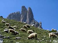 Sheep & Ansabère
 Ossau on Pau's rugby jersey
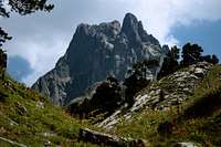 Ossau
OssauThe Béarn is a very old French region, located on the foothills of the Western Pyrenees. "Béarn" is the francized word for "Biarn" in the local dialect, the "Béarnais", whose roots are both latin (Occitan) and local (close to the Basque, formerly used in most of the Pyrenean range). The name Béarn comes from Beneharnum, a city destroyed by Vikings in 840.
Just like its two neighboring kingdoms the Bigorre and the Ariège, the geographic definition of the Béarn can be defined as simply as a watershed, more precisely two in this occurrence, beds of the "Gaves" local word for a river). In the the two main valleys, Aspe and Ossau, flow respectively the Gave d'Aspe and the Gave d'Ossau, merging later with the Gave de Pau out of the mountainous area. All of them form the western group of tributaries of the Adour river.
As for regionalism, the "Béarnais" folks rather define themselves as the remote cousins of the Basques, whose language share a lot of etymology. Both regions of the french Basque Country and the Béarn are also regrouped into the administrative département of "Pyrénées Atlantiques" (64), which is the only Pyrenean departement that belongs to the Aquitaine region.
But when it comes about the origin of the French beret, the Béarnais are proud to revendicate its origin, believed mistakenly by the majority as being Basque ! :) Pau, the indisputable regional metropolis, and very nice city to visit, is usually known as the capital, despite Orthez is the historical one. One must see Henri IV's castle, and wander on the "Boulevard des Pyrénees", the mountainous counterpart of Nice's seaside "Promenade des Anglais", panorama in the middle of which throne the remote but prominent Ossau.
 Winter panorama from Pau's "Boulevard des Pyrénées", Ossau in the distance
 Pau's Boulevard des Pyrenees in the 19th
 Laruns, long ago
 Ossau on Ogeu spring water
 The Ossau, cheese logo
The architecture of mountain villages has a local touch that makes it easily differentiable from what can be commonly seen in most of the central Pyrenees. Walls are brighter, but the most remarkable features are the omnipresent wooden balconies on it, as well as the roofs, more often made of red tiles than gray slates, and whose curved concave endings seem to be made for more shelter.
Finally, the Béarn has one of the greatest gastronomy. Rains from the Atlantic combined to sunshine, rich grounds, varied topography, and cool temperature, steadier than further East in the range, provide ideal condition for all sort of vegetables and cattle. On the foothills is produced the Jurançon, white wine of highest quality in southern France; as for the cheeses, they are incomparable: the hillsides of the Béarn, with a lot of green, own a very rich pastoral activity. The world-famous Sauce Béarnaise, often accompanying red meat, is an example.
 Aspe group
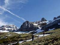 Hiking to Aspe
 Rock-Climbing on Balaïtous
 Mysterious mountains...
 Mysterious mountains...
Let's talk now about mountains. The Béarn is the "beginning" of the high mountains. Rare are the mountains over 2000m west from its limits, where the Lescun group suddenly give place to the high mountains sceneries. The altitude goes crescendo all over the border ridge, until inaugurating the first three-thousander, the majestic Balaïtous, on Eastern border and shared with the Bigorre. Just like Pic d'Anie, on the West side, introduced the first point over 2500.
But none of these landmarks are the most emblematic mountain of the Béarn. Just like the Bigorre, it has its own "Pic du Midi", name to which we add "d'Ossau" to avoid confusion, or just "L'Ossau"... if a single confusion is possible in the world of mountaineers, such the "Pyrenean Matterhorn", is rich in rock-climbing routes.
Some other mountains on the border with Spain make the fame of the Béarn, near the passes of Somport and Pourtalet. On the East, in the area of Gourette, a last excentred group, famous for panoramic views to the range, makes the fame of the region.
Surprisingly, despite two road passes that ease the access, many mountains, the most famous apart, are relatively unknow amongst Spanish mountaineers.
Coverage and Subregions
 Passage d'orteig
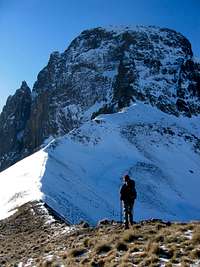 Col de Suzon
 Aiguilles d'Ansabère
 Arlet lake
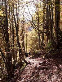 Arlet forest
 Espelunguère waterfall
 Lecherines ice cave
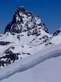 Snowy Ossau
The limits of the Béarn, as we chose to present it on SummitPost, could be defined as follows: it corresponds to the watershed of the Gave d'Aspe, Gave d'Ossau, and Gave de Pau on the north.
These three valleys correspond to the three colored areas of low hills on the north. We chose to introduce the high regions rather by groups, and the geology matches also ideally these divitions :
- The Lescun-Aspe group left to Gave d'Aspe, with dolomitic limestone
- The Ossau-Sesques group between Gave d'Aspe and Gave d'Ossau, volcanic
- The Lurien-Pallas group, granitic lacustrine area
- The Ger-Gabizos group on the East of Gave d'Ossau, brittle schists
View Béarn in a larger map
The Béarn is bordered :
- On the West by the Eastern French Basque country, a region that is not implemented yet on Summitpost, but that makes the continuity of the Roncesvalles-Irati area, to which it briefly connects on the left-bottom corner.
- On the south-west, facing the Lescun group, to the Belagua-Hecho area.
- On the central southern part, facing the Ossau group, to the Canfranc area.
- On the south-east part, facing the Balaïtous group, to the Upper Tena area.
- On the east, with the Bigorre. It first goes along the water divide made by the Balaïtous and the Gabizos, then across the shared county of Lavedan, that corresponds roughly to the Gave de Pau watershed.
Like some others area of the Pyrenees, few peaks of the border zone whose top is entirely in Spain were included, since they have routes and trailheads in both countries.
Getting There
 La-Pierre-Saint-Martin pass
 Col du Somport
By public transports
Both valleys of Aspe and Ossau are well served by the SNCF bus lines, until the border for the first, until Laruns or Gourette for the second. You will have no trouble to find your way to the Pyrenees from the Pau main railway station. Other private transporters may allow to get into the range as well, but this kind of data is always changing, and the best advice is to contact the tourist information of a specific place to get the information needed. There might be as well some private shuttles to the ski resorts of Arette, Somport or Gourette, in winter.
All timetables can be checked on the SNCF website : www.voyages-sncf.com.
 Estanguet, 1970
 Estanguet, 1970
 Getting there...
 Lurien
 After the storm
 Arriel from Arrémoulit
 Balaïtous
 Lakes of Arriel and Palas...
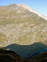 Pic d'Isabe
 Acherito summit panorama
Railway of Vallée d'Aspe, the story
From the cultural point of view, in the Béarn, it is almost compulsory to tell about the discontinued railway line that ran into the Aspe Valley and linked to Spain... Until Mars 27th 1970, when occurred the "accident du pont de l'Estanguet" as locals call it. Officially, this is was terrible combination of bad circumstances, mainly due to cold, that resulted in few wagons crashing into a beam of the bridge, concluding a wild descent with inoperative brakes. The bridge collapsed into the ravine, but fortunately no one died. Other unofficial versions spread all sort of rumors like mechanics being drunk. But the point is not there. Immediately after, the SNCF decided to close the line once and for all... to the big dismay of Spain, who had built at great cost a not less spectacular line into their chaotic mountains, in order to connect the rest of Europe, just after the now disused train station of Canfranc, as masterpiece as gorgeous as Madrid or Paris... This unilateral decision caused a real diplomatic incident between both countries, especially when it is common knowledge that the operating costs of the line were the real reason, and that the SNCF found a perfect pretext... For this reason, Canfranc has now become a sort of symbol of the perverted capitalism.
Since the construction of the Tunnel du Somport, meant to ease the drive through the ridge but locally perceived like a forthcoming motorway of lorries, the recurrent problem of overloaded motorways on the Catalunyan and Basque coasts, and the never-ending debate about where to place the future "Tunnel under the Pyrenees" (something for the TGV meant to be as huge as the Gotthard), the idea of reopening the Aspe line for piggyback purposes is uninterruptedly defended by ecologist for more than 40 years...
 Spain by car
Contrary to most of the regions in the Central Pyrenees, the Béarn is well-provided with trans-border roads. There are the passes of Pourtalet and Somport, but also La-Pierre-Saint-Martin just next to the west limit of the Béarn, in the Haute Soule.
 France by car
The A64 motorway that runs along the Pyrenees is a hub to each possible valleys. On the other hand, the weakness of the Béarn is the lack of communication axis parallel to the range, especially between the Aspe and Ossau, the two emblematic valleys. To get from one to the other, driving down to the very base of the mountains is needed, completely on the north in the neighborhood of Oloron (Col de Marie-Blanque, 1035m, from Escot to Bielle). Sabiñago via the southern side is shorter in many cases !
However, there are other passes more east and more west: Col de Bouesou (1009m) allows switching from La-Pierre-Saint-Martin to the Aspe Valley, and Col d'Aubisque (1709) from the Ossau valley to Argelès in the Bigorre.
View Larger Map
 Weasel
Nature and regulations
 Chamois
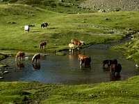 Horses near Ayous
 Chamois on Pic D'Anéou
 Bear hunting, long ago
 Larra karst
 Lescun
The regulations of the National Park specify that :
- One can wildcamp or bicouac in mountains as far as one hour of walk away minimum from a road, only during the night or by bad weather, between 19pm and 9am.
- Dogs forbidden
- Fires forbidden
- Rubbish forbidden
- Flower-picking forbidden, no Hunting
- Motors (4x4, motorbikes) forbidden
- Mountain bike authorized only on designated tracks
- Paragliding forbidden
- No noise...
- Fishing allowed in certain conditions. Regulations even more complex for sub-alpine mountain lakes.
The area covered by the Béarn is quite varied when it comes about fauna and wildlife diversity.
The Isards (Pyrenean name of the chamois) are met in huge herds, especially in the limestone zones near the border. Brown vultures, one of the largest bird of prey in Europe, is seen over almost every possible ascending stream, flying in large circles. The hardwood forests of the lower hillsides are a dream land for the deers. And the mountain lakes of the Balaïtous area host countless species of fishes and algaes.
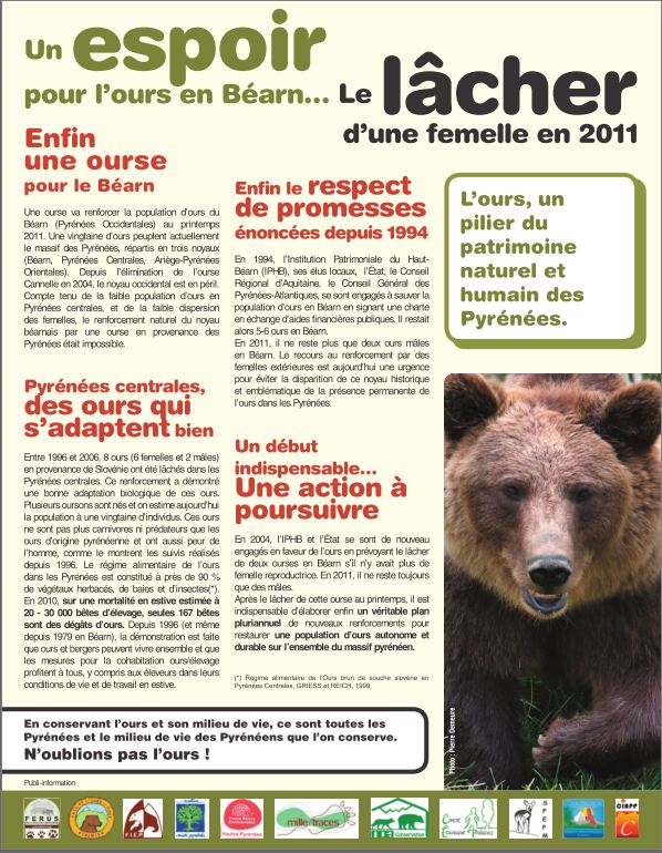
But the most famous inhabitant is certainly the bear... despite nowadays, according to experts, there is no evident proof that a single bear is remaining in the Béarn following the shooting of Canelle, last endemic female, and the natural death of Camille, the main dominant male of the region... Sadly, only the presence of Canellito, Canelle's son, very hypothetic since no trace of him (he was left orphane kind of too young), plus another mysterious unidentified animal, nicknamed "Aspe-Ouest", make people affirm the bear is still populating the Béarn...
Recently, the bear is in the center of a new polemic. According to a consensus found in 2010 by the former state secretary for ecology Chantal Jouanno, stating that no extra bears would not be reintroduced except for replacing those killed by humans, one animal, probably from Slovenia, is to be released in the Béarn for the 2011 season. A female, in order to reproduce with the few males there. This notification irked the few locals who misunderstood too quickly the end of reintroductions...
Lescun-Aspe group
 Lescun & Ansabère
 Anie
Anie Ansabére
 Sunrise on Cirque de Lescun
 Arlet
ArletThe Cirque de Lescun, presented through this album, is commonly mentioned amongst the wonders of the French Pyrenees and their national park.
It consists in a set of mountains, running along the south-west border and ridge of the Béarn, on the left side of the Gave d'Aspe, and describing almost a half-circle whose centre is the pretty village of Lescun. The inside faces of most of them are quite vertical, and both of these geometric characteristics explain the appellation of "Cirque". This shape is not so noticeable from Lescun or in the Cirque itself, but suddenly becomes obvious as we elevate towards any summit.
In the order, from North to South, the main actors are as follow: the Orgues de Camplong (2038), Soum Couy (2311), Pic Anie (2504), le Billare (2309), la Table des Trois Rois (2444m; "Mesa de los Tres Reyes"), Pic d'Ansabère (2366 m; "Petrechema"), Pic de Petragème (2259; "Sobarcal"), Trois Dent of La Chourique (2141), Chourique (2084), Pic du Lac de la Chourique (2138), Pic de Laraille (2147), Pourtet Barrat (2101m), Pourtet Ouvert (2131m), Pic de Lariste (2168), Marmida (2076), Cotdoguy (2019), Risté (2109), Pic de Burcq (2105m), and Pic Bacqué (2093). As the name of one tells, there is a splendid lake to see just over the border, Ibon de Acherito.
 Ibon de Acherito
 Aspe group seen from North
 Espelunguère
Some other tops are standing slightly setback from the ridge but can be climbed from the Cirque as conveniently than the others, like the Acherito, named after the lake. Along with other neighboring not less gorgeous mountains that make their continuity further south in Spain, this region is sometimes nicknamed the "Pyrenean Dolomites". Only this ! One hut is located in the Cirque, on the route to Pic d'Anie, Refuge de Labérouat.
 Aspe north face
 The Circo de Olibon
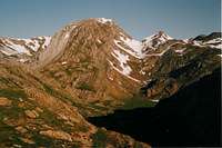 Visaurin
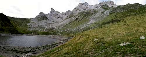 Lac de Lhurs
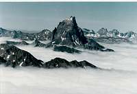 Ossau from North
Further south than the Lescun group, and after a depression on the border ridge, this group of limestone mountains grows again in elevation, going until the Somport pass. Peaks are less individualized than in the Cirque de Lescun, but few of them are outstanding, like Pic de Labigouer (2175), Pic du Baralet (2052) Pic Rouge (2477), Pic d'Arlet (2205), Pic d'Espelunguère (2258), and the Pic d'Aspe (2645). Despite being on the ridge, this summit is entirely located in Spain due to the "anomaly" of the administrative border that avoids temporarily the water divide in the upper end of the valley. However, it gave its name the the Aspe Valley, and makes a not less emblematic peak of the Béarn. Next to it stands the Peña Blanca (2180).
The "Forges d'Abel", last settlement before the border, is the usual trailhead. As the name tells, iron was forged since immemorial times, but nowadays not much is to see apart from the power plant.
This area is also as famous for few passes. Espelunguère, also called Port de l'Escale, provides the standard access to the upper valley of Río Aragón. Port de Bernère (Bernera) allows the access to the magnificent lake of Estaens (Ibón de Astanes), with its curious shores of red sandstone. The Pas d'Aspe near the eponymous peak is a rough bottleneck that provides access to the upper valley, and probably explains the location of the border at this very spot.
One hut is located in thes southern Aspe valley, near the homonym peak ,Refuge d'Arlet.
 From South
Ossau-Sesques group
 From West
 From East
 Refuge de Pombie & Ossau
 Pic de Sesques & Lac d'Isabe
The mountainous zone that separates the valleys of Aspe and Ossau is like no other place in Europe, largely due to the geology. Just by looking at the topographic map, we notice how the configuration is uncommon.
Most of the Pyrenees are made of valleys and sub-valleys, ranges and subbranches subordinated to each other, in accordance with the most usual flows of erosion. But here, something infringed all these laws.
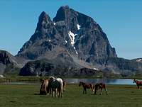
The line, water divide between the "Gaves" of Aspe and Ossau, made of red sandstones, looks like the bloody edge of a wound. And the mass on the right is the trespasser: the Midi d'Ossau, whose prominence exceeds 1000m on every face, making it the 7th prominent peak of the whole Pyrenees, just before Vignemale and a mass of 3000ers!
His lone shape is explained by the fact this mountain is the remain of a solidified volcanic chimney. Volcanic activity whose remains are even more visible behind the border, in the Anayet area, where basalt is found. However, the stone of the Ossau is not basalt, but rather a kind of polymorphic rock closer to hercynian granite, whose particularity is to be quite porous. For this very reason, the rock offers an excellent grip and is very appreciated by rock-climbers. Erratic blocs of this nature can be found as far as the neighborhood of the city of Arudy, on the Piedmont, witnessing the activity of the glaciers that shaped this mountain, removing the more tender rock that surrounded it.
 Chemin de la mâture
 Midi in Winter
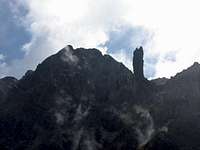 Sérous & Capéran de Sesques
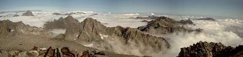 Balaïtous western Panorama
 Pic D'Anéou
The Ossau, despite its omnipresence, is not the only hiking destination, far from that. Some great trails and secondary summits are located between the passes of Somport and Pourtalet.
Pic des Moines (2349) is a sort of Ossau in miniature, since made of the same rock. Peyreguet (2487), closest peak from the Ossau, shares this property too. Gradillère (2271) too.
Pic d'Anéou (2364), is the culminating point of a wide grassy zone, Cirque d'Anéou, appreciated by skiers in winter as it makes a perfect terrain.
On the West, the hike to the lakes of Ayous, and possibly till the pass or even the peak d'Ayous (2288) provide the world-wide known views of the Ossau overlooking these beautiful waters and reflections on it. Col d'Ayous can be reached from Etsaut in the Aspe valley, via a fantastic trail called Chemin de la Mâture, dug into a vertical cliff by men several centuries ago, in order to ease the transport of fir truncs, intended for the manufacture of ship masts (whose name come from masts=mât). A hut near Lac d'Ayous : Refuge d'Ayous
Many people also undertake a popular hike called the "Tour de l'Ossau", a breath-taking day-hike which, as the name suggests, uses the trails circumventing as close as possible the Ossau mountain. This via the Bious-Artigues reservoir (served by road from April to December), the Col de Suzon, gate to the Ossau's "normal route", and Refuge de Pombie. Further down in the valley, rather a mountaineering hotel than a mountain hut, near the road, stands the Chalet-Refuge de Gabas. Beware, there is a hut called "Refuge de Bious-Artigues Pyrénéa-Sports" near the dam but is discontinued.
 Lac Roumassot
 Pic Montaut
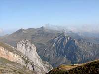 Montagnon d'Iseye
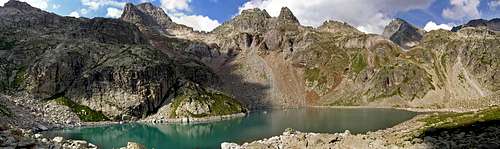 Balaïtous & Arriel panorama
 Pic d'Arriel
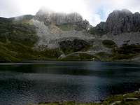
Further north spreads another remarquable massif, the second in importance after the Ossau: the Pic de Sesques, also called "l'Escarpu" (2606). On its NE corrie lie a beautiful lake, Lac d'Isabe. Beware, despite this elevation that can seem relatively modest compared to other neighbouring peaks in the Pyrenees, there is almost 2000m of elevation to hike to reach the top ! Just for this reason, this is certainly a challenging hiking goal. Few neighbouring tops share its popularity, like Capéran de Sesques (2606) and Pic Gaziès (2457) on the south, or Pic d'Isabe (2463) and Permayou (2344) on the north, until a wide pass, Col d'Iseye (1829). The upper valley that spreads from Lac d'Isabe to Col d'Iseye is accessed via the magnificent Gorge du Bitet, popular amongst local canyoneers, and in which a forestry track goes up.
A last mountain group stands north from the Iseye pass, and hosts three summits of interest: Montagnon d'Iseye (2173), Pic Montaut (2016), and the Bergon or Ilhec (2148), as well as one pretty lake, Lac du Montagnon. Despite their relatively small elevation that classifies them into the category of Pre-Pyrenean foresummits flirting with the 2000m limit, hikers should not be mistaken, they are quite rocky, especially
the Bergon and the Montaut, true fortresses.
Lurien-Pallas group
 Arriel & Arrémoulitl
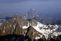 Pallas & Ossau
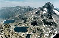 Pallas & Arrémoulit
 Arriel panorama from Artouste
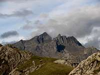 Lurien
The east side of the Ossau valley sees the Ossau volcanic granite turning into plain metamorphic granite, and the landscape changing into a mineral and lacustrine chaos, similar in many ways to what we see in many other regions of the range.
This unit is indeed the western extension of the Lutour - Marcadau group in the Bigorre and the Infierno region in the upper Tena valley. All together, these territories form a complex unit as rich in lakes, ridges, valleys, rivers, as Aïgues-Tortes or the Néouvielle.
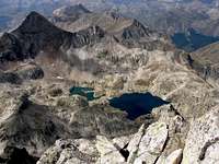
Despite not exactly in the territory of the Béarn, the king of the area is the Balaïtous (3144), first three-thousander of the range from the west. Strictly in the Béarn, three peaks share a very high popularity : the Pallas (2974), the Lurien (2826) and the Arriel (2824).
The Pallas, often described like the "little brother" of the Balaïtous (Peytier and Hossard, its first ascenders, climbed the Pallas by mistake during a first attempt in 1825 !) is a proud conic and sharp pyramid, the stereotype of the beautiful mountain. The Lurien, more longiform and complex, is another splendid individualized mountain. On the border ridge stands the Arriel, also called Pic Saget, a fine hiking goal, the easiest of the three.
 Artouste train
 Lac d'Artouste
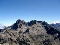 Balaïtous
 Grand Gabizos
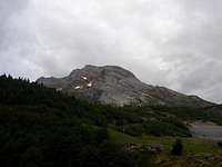 Pic de Ger
The Lacs d'Arrémoulit, a constellation of natural lakes nestled in a vertiginous rocky amphitheater, form a site of an extraordinary beauty. A hut stands in this nice site: Refuge d'Arrémoulit. Not very far is stretching a long-shaped dark lake, Lac d'Arrious. These two sites are linked by a locally very famous trail, equipped as a Via Ferrata, called Passage d'Orteig, after the name of the guide who "invented it" in 1870. This itinerary saves 45mn, avoiding a strenuous descent to the lake of Artouste.
Lac d'Artouste is a large round lake, whose level was artificially lifted up for power purposes by a dam. The particularity of this site is to be served by the highest train of Europe, a narrow-gauge line that reaches the elevation of 2000, built in 1929 for the construction of the reservoir, and used nowadays only for touristic purposes. The line starts in Fabrèges, a point on the mountainside of the Pic de la Sagette (2031) served by a cable-lift.
Some secondary peaks make other less known hiking goals in the area, such as Pic d'Ormielas (2240), Petit Lurien (2358), Arrious (2826), Pic des Tourettes (2771), Pic de la Lie (2673) or Pic d'Artouste (2816). Several passes connect to the Spanish side, such as Col de Pallas (2517) or Col de Sobe (2449), or to the Bigorre, via Col de la Lie (2469), Col d'Artouste (2451), Col d'Auseilla (2353) or Col d'Uzious (2236). The northernmost group of peaks is also visited conveniently from the Azun valley, in the Bigorre, that visits the splendid lakes of Lac de Pouey Laün and Lac du Migouleou.
Ger-Gabizos
 Pène Sarrière
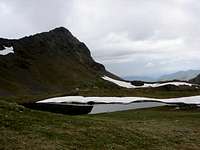 Sanctus
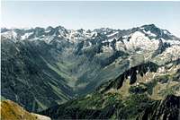 South view to Azun
 Cirque du Litor
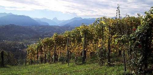 Jurançon wineyards on the Béarn foothills
 Forest in the spring
The previous area connects further north to a group of mountains still of significant importance, and located in the neighborhood of the ski-resort of Gourette, trailhead for many of them.
The separation occurs at the wide pass of Col d'Auseilla, where the geologic transition occurs and granite gives place to schists and sedimentary stones of varied kind.
Despite of this, the southern side of this region hosts three lakes of significant importance and remarkable beauty: Lac d'Anglas, lac d'Uzious, largest, and Lac du Lavedan. The three are visited in the same day, and despite the lack of significant summit nearby, justify well the hike.
This group of lake separates the two large units that form this mountainous group, with a respective emblematic top for each of them: Pic de Ger on the west, and Grand Gabizos on the east. Pic de Ger is not to be confused with an smaller homonym, "Pic du Ger", in the Bigorre.
Pic de Ger (2613) is a spendid limestone mountain, a Vignemale in miniature, with a complex shape ond network of ridges and subvalleys. Its secondary summits are the Grande Arcizette (2513), the Pic d'Amoulat, Pène Médaa (2488), Pène Sarrière (1944m). All of them are made of bright jurassic limestone.
Grand Gabizos (2691), belongs to a much wilder zone made of sharp rocky ridges, mainly of dark and unstable schist. Petit Gabizos (2522), Latte de Bazen (2472m), Esquerra (2453m), Sanctus (2482m), Soum de Grum (1870m), Géougue d’Arre (2619m) are the other surrounding tops.
This mountainous group is suddenly interrupted on the north, where the road of Col d’Aubisque (1709m), important stage of Tour de France, and Col du Soulor (2474), make the separation with the low mountains.
In the area you have some vias ferratas as Siala, near of Gourette.
The area is finally worth mentionning for its natural thermal resorts, whose names are very evocative: Eaux-Bonnes, Eaux-Chaudes, in the neighbourhood of Laruns, main village in the valley, also worth seeing for its splendid old architecture.
Piedmont
 Waterfall in autumn
 Houndas chapel
 Cromlechs of Lou Courau
 Lescun campsite
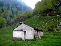 Bious-Artigues hut
Since the Béarn cease to be a part of the Central Pyrenees, the "thickness" of the range is not as big as further East, and consequently, the elevation decreases much quicker on the North to match what we defined as "low mountains" in other French areas of the range (Lavedan, Baronnies, Bas-Luchonnais, Comminges). Unlike the others also, there is no defined name for the whole region of the forehills in the Béarn. One will simply designate the lower Vallée d'Aspe or Vallée d'Ossau.
The lower Vallée d'Aspe, pretty and human-sized, is said to be the "traditional pass of the bears", since they used to take this valley to cross to the other side of the main ridge. Despite very few of them remain nowadays (see nature). In the western side of the valley stand the Trône du Roi (1266), the Saraillé (1242), the Layens (1625). On the eastern side: the Mail Arrouy (1251), the Roumendarès (1646), the Ourlène (1814), Mailh Massibé (1973), Montagnou (1973).
The Ossau valley owns higher peaks in its length, but also smaller other treasures further down: Pic d' Aule (2392), Gourzy (1917m), Cézy (2209m). But the interest is not only in peaks and panoramas. The Ossau forehills also host other hidden treasures like the Cromlechs (prehistoric pillar stones, like a miniature Stonehenge) of Lou Courau near Bilhères, or the Dolmen of Lo Calhau de Teberno near Arudy.
Accomodation
 Cabane de Lhurs
 Cabane de Borce
 Arlet Hut
 Refuge d'Ayous
 Refuge d'Arrémoulit
 Balaïtous, Arriel, Palas
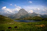 Midi in Summer
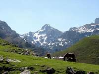 Near Acherito
Bivouacking, wild-camping
As mentioned in the red tape, overnight camping is allowed, if your tent is located at least 1 hour away from any road or mountain hut. Camping near mountain huts, using them only for eating and toilets purposes is allowed, despite it can be a surprising attitude in other countries. Removing the tent in the morning is required, despite leaving it the time of the hike is usually tolerated.
Unguarded huts and shelters
The Pyrenees have an incredible amount of places of this kind, which are inventoried in this fantastic site : www.pyrenees-refuges.com. This interactive map allows to locate them : http://www.geopyrenees.net (click "cabanes"). However, the Béarn is known to have most of them closed because private, and in use by the shepherds. If you choose to use one while having a doubt, behave as polite as possible if you meet the owners... If you do and try to talk with them about your tomorrow's goals, there is a reasonable chance they will let you stay.
Official Campsites
One will find several convenient campsites in both the Ossau and Aspe valleys, mostly in the touristic centers. In the Aspe Valley, the Lescun Campsite is the ideal spot, in a scenic location with a panorama to the mountains, what the mountaineer usually looks for. Such a campsite in the Ossau valley is likely to be the one in Bious-Artigues, just before the hut.
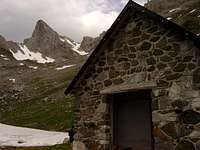
Guarded Mountain huts
Thanks to its popularity, the Béarn is well featured with mountain huts, however slightly less densely than the Bigorre, and excepted around the areas of the Ger and Gabizos. Near the border, they are close enough from each other to link themselves in a day-hike.
- Refuge de Labérouat
- Refuge d'Arlet
- Refuge d'Ayous
- Refuge de Pombie
- Chalet-Refuge de Gabas
- Refuge d'Arrémoulit
Accommodations in the valleys
All the previously mentioned valleys have a crowd of possible accommodations. The most simple is to type places names in Google, or to check the touristic portals of these resorts and valleys:
- www.vallee-aspe.com
- www.valleedossau-tourisme.com
Maps (paper and numeric)
[img:659360:alignleft:small:shadow of ... which mountain?][img:48474:alignright:small:Balaïtous, Arriel, Palas][img:260827:alignleft:small:Midi in Summer][img:293050:alignright:small:Near Acherito]
Numeric maps
Due to the copyright policy of the IGN, it is not possible to scan and include map samples without permission. The only way to consult them online is via the database Géoportail, easily browsable via the site ClicGPX (we need to unzoom, move to the western Pyrenees and rezoom again)
Paper maps
Two types of maps are usually found in France for the Pyrenees :
- The TOP 25 series of IGN, high quality maps at the 1/25000 scale, mandatory for hiking all high regions mentioned above. Several maps cover the area described in this page: 1547OT (Aspe/Ossau), 1546OT (Oloron), 1546ET (Laruns), 1647OT (Balaïtous), 1647ET (Lavedan). See the France index for a more accurate look.
- The Rando Editions series, at the 1/50000 scale. This kind of map is usually enough if we stick to the trails, as well as for the soft relief of the lower mountains. One whole map covers the whole area : the N° 3 Béarn.

