

-
 24287 Hits
-
 95.01% Score
-
 50 Votes
|
|
Route |
|---|---|
|
|
46.37800°N / 9.96000°E |
|
|
Download GPX » View Route on Map |
|
|
Mountaineering |
|
|
Summer |
|
|
A long day |
|
|
PD+, UIAA II |
|
|
Overview
Piz Palü Traverse
Piz Palü (Swiss toponym) or Piz Palù (Italian toponym) is a beautiful mountain located between the Forcola Bellavista to the West and the Fuorcla Pers-Palù to the East, is one of the finest mountains not only in the Bernina massif, but in the whole Rhaetian Alps. This very important and famous mountain has 3 summits located on the main ice-covered watershed: the East summit 3882 m, the Central summit 3905 m (Muot dal Palü), the highest, and the West summit 3823m (Piz Spinas).
Part of the ridge joining the three summits runs along the Swiss-Italian border, but the main summit lies in Switzerland. According to the Swiss top map, coming from the west, the border with Italy runs along the ridge up and over the Western summit and beyond, to the edge of the central summit plateau. There it leaves the ridge to continue along a southern spur. However, the highest point is about 150 m further east on the plateau, so the true summit is on Swiss soil.
Traversing all three is a wonderful tour in the Eastern Alps, and on a normal day there are usually several groups on the mountain. The traverse was first done by Wachtler and Walner with Georg, Hans and Christian Grass, 22 August 1868. The traverse can either be done from west to east or the other way around. A note on the pro’s and cons follows after the route descriptions.
Key points of the route
- Fantastic scenery.
- Varied alpine climbing.
- In normal conditions, the west ridge of Piz Spinas, the western summit, is a rocky scramble, UIAA grade II.
- The ridge between the central and eastern peak is very exposed.
- The upper part of the Pers glacier has lots of crevasses.
Getting There
There are three relevant mountain refuges near Piz Palü.
- - Rifugio Marco e Rosa, conveniently high at 3597 m, lies just south of Piz Bernina and about 4 km west of the main summit of Piz Palü.
- - Berghaus Diavolezza, 2973 m (not on SP (yet), located at 46.412 N, 9.965 E) lies about 4 km north of Piz Palü. It is a cross between a mountain refuge and a regular hotel. It can be reached by the Diavolezza cable car from the Bernina Valley. You can park your car at the big parking lot of the cable car. Using public transport, the train station Bernina Lagalb is right at the bottom of the cable car, and busses stop there too. By train it takes about half an hour to Pontresina and 45 minutes to Sankt Moritz. It’s a touristic line, the Bernina Express, which drives very slowly to give the passengers ample time to enjoy the scenery. The bus is faster.
- - Chamanna da Boval, 2495 m (46.415 N, 9.925 E) lies about 5 km north west. It is an alpine refuge owned by the Swiss Alpine Club.
When doing the traverse as a single trip, Berghaus Diavolezza is the best option. On a longer tour, any of these refuges can be used.
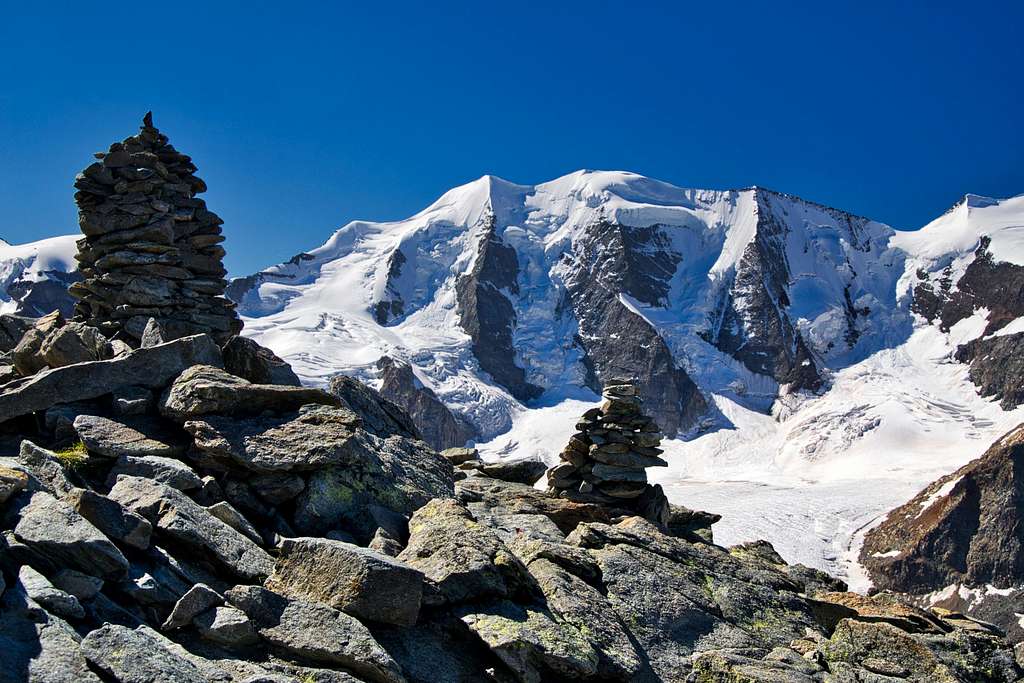
 View from high on Piz Bernina, it shows the traverse and most of the routes to and from it. High up, just left of center, is the rocky ridge of Piz Spinas, the west summit of Piz Palü. Below that is the Fortezza ridge, which is the route between Fuorcla Bellavista and Berghaus Diavolezza. The rocky peak on the left is Piz Trovat.
Route Description

On the Morteratsch Glacier, just east of Rifugio Marco e Rosa

Piz Bernina from the trail to Bellavista
Options
The easiest way to do the traverse is from Rifugio Marco e Rosa to Berghaus Diavolezza, because with the refuge already at 3597 m, it involves the least total ascent, about 500 m.
As a day trip, it is normally done from Berghaus Diavolezza, simply because that can be reached so conveniently from the valley. Still, it's common to come up to Diavolezza the day before, because you want to start early. Using the normal route over Isla Persa, it's 1500 m up and down.
The West-East traverse from Marco e Rosa to Diavolezza

And now really the last look back at the hut
Getting to the Western saddle
From Marco e Rosa, the beginning is the same as the normal route to Berghaus Diavolezza over the Fortezza ridge, so probably there is a trail you can follow. Head in a general direction of about 80º, towards the glacier just north of Bellavista. If there is no trail, you’ll have to find your own way around the few crevasses and ice formations that block the direct route.

Looking for the way up to Fuorcla Bellavista

Getting ready for Piz Spinas
After half an hour or so, you should have the main summit of Bellavista on your right. The Bellavista summit ridge continues for about 1 km. Keep walking east alongside it, until you can spot a saddle on your right. That's Fuorcla Bellavista (3688), the saddle between Bellavista and Piz Palü. Note that the normal route to Berghaus Diavolezza doesn’t go up there, but turns north before the saddle, where it descends along the Fortezza ridge. See the east-west traverse for more on that.

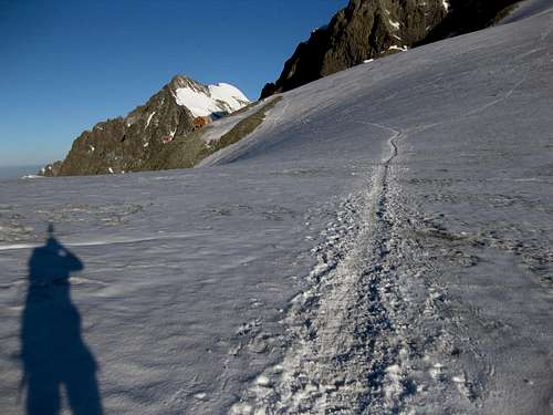
Piz Spinas west ridge
The ridge
From west to east, the traverse proper starts at Fuorcla Bellavista. At this saddle, you’ll see the rocky west ridge of Piz Spinas, the western summit of Piz Palü. On the ridge itself, you can't get lost (you could fall off it, but that would be something different.

Scrambling up Piz Spinas
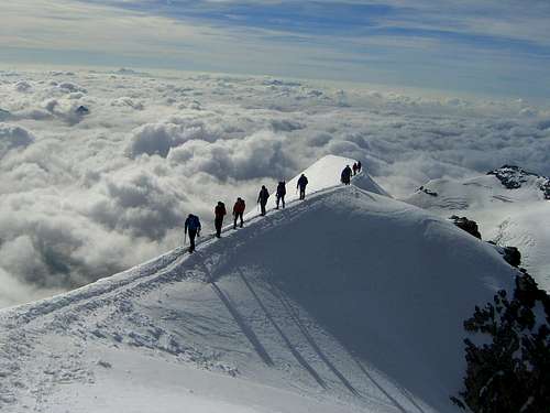
Ascend the rocky ridge to Piz Spinas (3823), grade II. From there, the ridge continues not too steep to to the main, central, summit (3900 m).
The eastern summit (3882) is reached over an exhilarating knife edge ridge and finally there is a beautiful steep descent (gradient up to 40º, but mostly less) on the eastern ridge to an unnamed saddle. If there is pure ice on this steep descent, you might consider placing an ice screw.
Don’t continue too far along the ridge. Shortly after it starts turning north and the Pers Glacier to your left flattens out enough to be comfortable, leave the ridge. That way you avoid the final steep ridge to Fuorcla Pers-Palü, the saddle between Piz Palü and Piz Cambrena.
 On the east ridge. Picture by Sebastian Hamm
 Descending the E ridge Descending the E ridge |
 Upper slopes of the E summit Upper slopes of the E summit |
 The slope of the E summit The slope of the E summit |
 The trail down from Piz Palü E The trail down from Piz Palü E |
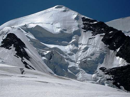 Seracs on the north of Palü east. You don't want to be under there. The route passes well to the left of this picture. Note the cornice on the summit.
Crossing the Pers Glacier to Berghaus Diavolezza
From the point where you leave the ridge, look north (as if you didn’t do that before ...). About three km away is Piz Trovat, on the edge of the glacier. To get to Berghaus Diavolezza, you have to pass Piz Trovat on the east side.
After leaving the ridge, go north on the Pers Glacier. Especially the upper part of this glacier has lots of crevasses. If there is no trail, you'll have to negotiate a way through. If you go too far to your right, rockfall from the slopes of Piz Cambrena might be an issue, so better avoid that. As the glacier flattens out, well past Piz Cambrena, the going gets easier and you can go straight.

Looking north to Piz Cambrena from the Pers Glacier, right next to Fuorcla Trovat.
Once you've reached the small ridge just south east of Piz Trovat, hike up and over it, then follow the trail, which more or less follows the contours while traversing the east side of Piz Trovat. Pass over a saddle north east of Piz Trovat. After the saddle, the route gradually turns more to the west and in a few minutes you'll reach Berghaus Diavolezza.
The traverse as a round trip from Berghaus Diavolezza
As a round trip, the traverse can be done in either direction. The description given is from east to west.
Getting to the eastern saddle
The route starts counter intuitively by going south east first, but before long it turns south, along the east side of Piz Trovaz. There is a trail, but if it's not visible due to fresh snow, try to keep the same altitude when skirting Piz Trovat. After half an hour or so, following the contours would lead you east again, but instead the trail goes over a small ridge to the Pers Glacier. This small saddle is called Fuorcla Trovat.

Piz Cambrena from Piz Palü
Since an early start would be a good idea, you might consider checking out this part of the route the day before instead of searching for it in the dark.
On the Pers Glacier, head south and aim for the saddle directly east of Piz Palü east. If you cannot see the peak and the saddle, you should think about alternatives. You'll need good route finding skills to do this route in poor visibility. The saddle to aim for is not the lowest saddle in the ridge, but the one to the right of that.
For the first part, the glacier is flat and doesn't have many crevasses, but that changes as soon as you pass the north western spur of Piz Cambrena on your left. After that, you'll have to negotiate a way through the crevasses, and it's no longer flat either. Keep going south until you reach the ridge.

Looking west over Piz Spinas to Piz Bernina
The ridge
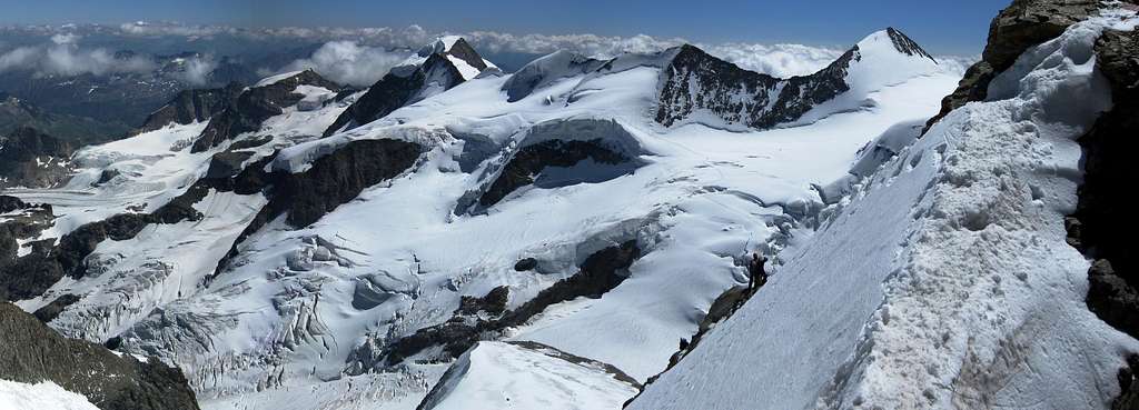
On the ridge itself, you cannot get lost. The ridge is somewhat steep, up to 40º, but not particularly narrow at first. Still, later in the summer it can be icy and a fall could be very dangerous. Between the eastern and central summit, the ridge is very exposed. The central summit is a big plateau. If the weather and conditions are good, you’ll probably have company there. After traversing to the western summit, Piz Spinas, descend its rocky west ridge to the saddle, Fuorcla Bellavista.
Piz Bernina and Piz Morteratsch from the Pers Glacier, NE of Piz Palù. On the left visible the descent from Fortezza on the alternative route
The descent from Fuorcla Bellavista
I have no personal experience with this particular part of the route. Thanks to Selinunte01 for valuable info.
At the saddle, traverse the east slopes of Bellavista to the north to the Fortezza ridge. See the dotted blue line on the map. Quite likely, you'll hit upon the trail between Rifugio Marco e Rosa and Berghaus Diavolleza not far north of the saddle.
Descend north on the glacier to the upper end of Fortezza arete. Don´t underestimate this ridge. As this is a northern exposure, snow and ice often lingers on the rocks even late in summer and you may be forced to climb with crampons.
The first steps on the arete are easy. Soon enough there is a steep chimney-like chute descending on the west side of Fortezza arete (UIAA gade II, excellent rock). The route gains the now broader arete again and descends in three more 'steps', mostly east of the ridge crest (UIAA grade I – II, exposed but good rock) down to the exposed and sharp ridge at the lower end of the arete.
There are fixed bolts, so you easily can rappel down or belay when climbing up. There are red stripes and arrows as additional route markers.
Watch out for the ice at the lower end of the arete. There was a near fatal accident in 2003: the bloke was rescued with a helicopter after sliding and falling down several 100 meters to Vadret da Morteratsch.
At this point there is a bit of a glacier that leads from the ridge down to the Pers Glacier to your right. You have two options now. From here, on the map, the normal route is the dotted blue line, the alternative the green one.
The normal route continues down north traversing the little Vadret de la Fortezza. There are some huge crevasses waiting for you on the upper end of that glacier. On the lower end is the rock island of Isla Persa (2720 m). Follow the moraine talus to the Isla Pers trail junction.
This rock island has a very steep north face. Fortunately, shortly before that, there is a cairned trail going east descending to the Pers Glacier, and there is a zig zag trail up to Berghaus Diavolezza on the other side. Unfortunately, the normal route involves hiking up some 300 m at the end of the day.
The normal route is definitely the right option if you want to go to the Chamanna da Boval. It is more complicated than it used to be, due to the glacier retreat. On Isla Persa, go west on a small trail which zig zags down to Vadret da Morteratsch. At the upper end of the side moraine head southwest until you can easily descend the loose moraine scree and talus flanking the glacier. (On Swiss Topo maps 1277 and 2521, the track goes down from Isla Pers to the confluence of Vadret da Morteratsch and Vadret Pers - due to glacier retreat that is not a good option any more!) Traverse the glacier to the other side moraine - a sometimes tricky action due to loose scree on the glacier and huge creeks full of melting water on hot summer afternoons. Fight yourself up to the moraines top where you probably will meet a trail heading north to Chamanna da Boval.
Alternatively, descend east from Fortezza to the Pers Glacier early, and cross it along the northern base of Piz Palü, following the contours at around 3000 m. Aim for the small north eastern ridge of Piz Trovat again, where you got on the Pers Glacier early on the day. Compared to the normal route, this avoids the final 300 m ascent, but crossing the Pers Glacier higher up means more crevasses to negotiate.
Chamanna da Boval
Rifugio Boval could be used as a base as well. Compared to Berghaus Diavolezza, that would add a few hundred meters more to the ascent or descent, and a bit more distance too, making it a very long day. However, if you go up (or down) along Isla Persa, the difference is small.
Which direction to choose?
When starting from Berghaus Diavolezza, the traverse can be done either way. Going east to west has the advantage of ascending all the rock sections, instead of down climbing or rappelling. The down side is that it will be later in the day when you have to cross the crevasse field on the upper Pers Glacier on coming down from the eastern summit. On a hot day, old snow bridges might be weak. For the visible crevasses, that’s not so big a problem, it’s the hidden ones that always worry me.
That said, we did the west-east traverse from Marco e Rosa to Berghaus Diavolezza, descending the upper Pers glacier in the early afternoon.
Red Tape
No fees no permits required
When to go
The traverse is mostly done in summer, when the alpine huts are open for business and avalanche risk is normally low or nonexistent. That said, the traverse is also done in other seasons, and, provided there is enough snow to fill the crevasses, when doing the traverse from west to east, a large part of the descent can be skied down the Pers Glacier.
Essential Gear

Don't forget your ice axe!
Full glacier travel equipment: crampons, ice axe, rope, harness, one or two ice screws (late in season there might be less or no snow on the glacier) and the usual collection of prusiks and carabiners to perform a crevasse rescue, just in case.
External Links
Swisstopo Excellent maps.
The nearby town of Pontresina.
Rhäetische Bahn is the company that exploits the Bernina Express.
www.wandermap.net I used this site to create the interactive route map.
Guidebooks and maps
1. Hochtouren Ostalpen, Edwin Schmitt,Wolfgang Pusch, ISBN 3763330100.
2. Swisstopo map 2521, St.Moritz Bernina, Ausgabe 2006.
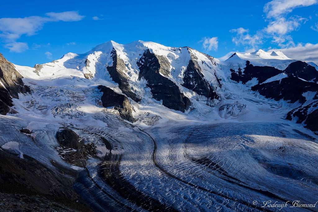
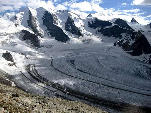 Piz Palü, Bellavista and Crast' Agüzza from the Diavolezza refuge.
selinunte01 - Feb 12, 2011 10:24 am - Voted 10/10
Addition for Fortezza routeI descended the Fortezza arête in summer 2003 after having climbed Piz Bernina via Spalla arete: Starting at Fuorcla Bellavista traverse the east slopes of Bellavista to the north until you reach the track from Marco e Rosa hut / Bellavista terrace. Descend north on the glacier to the upper end of Fortezza arete. The first steps on the arete are easy. Soon enough there is a steep chimney - like chute descending on the west side of Fortezza arete (UIAA gade II, excellent rock). The route gains the now broader arete again and descends in three more “steps” mostly east of the ridge crest (UIAA grade I – II, exposed but good rock) down to the exposed and sharp ridge at the lower end of the arete. There are fixed bolts so you easily can rappel down or belay when climbing up. There are red stripes and arrows as an additional route marker, too. Watch out for the ice at the lower end of the arete which occurs there in late summer. There was a near fatal accident when I had a rest day on Chamanna Boval: the bloke was rescued with a helicopter after sliding and falling down several 100 meters to Vadret da Morteratsch(!). Don´t underestimate Fortezza arete. As this is a northern exposure there often lingers snow and ice on the rocks and you may be forced to climb with crampons. Traverse the ice or snow ridge to the upper end of little Vadret da la Fortezza. There are some huge crevasses waiting for you on the upper end of that glacier. Go straight down on the Vadret da la Fortezza to its lower end and follow the moraine talus to the Isla Pers trail junction. There are some cairns and foot tracks in the moraine scree guiding you down. The route to Diavolezza is easy to find: just follow the good trail from Isla Pers in eastern direction down to the Vadret Pers, traverse the glacier and aim for the lower end of the zigzag trail coming down from Diavolezza hut. Zigzag up to the mountain hut and the lovely cablecar station. The route to Chamanna da Boval nowadays is more complicated, due to the glacier retreat. Head down west on a small trail which zigzags down Isla Pers in the direction to Vadret da Morteratsch. At the upper end of the side moraine head southwest until you can easily descend the loose moraine scree and talus flanking the glacier. (On the Swiss Piz Bernina map, scale 1:25.000, map number 1277, the track goes down from Isla Pers to the confluence of Vadret da Morteratsch and Vadret Pers - due to glacier retreat that is not a good option any more !) Traverse the glacier to the other side moraine - a sometimes tricky action due to loose scree on the glacier and huge creeks full of melting water on hot summer afternoons. Fight yourself up to the moraines top where you probably will meet a trail heading north to Chamanna da Boval.