
-
 31295 Hits
-
 98.67% Score
-
 87 Votes
|
|
Area/Range |
|---|---|
|
|
42.76329°N / 112.14104°W |
|
|
Hiking, Mountaineering, Trad Climbing, Scrambling, Skiing |
|
|
Spring, Summer, Fall, Winter |
|
|
9271 ft / 2826 m |
|
|
Overview
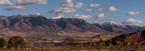
 Bonneville Peak
The Portneuf Range is located in Southeast Idaho. It is east of the Bannock Range and west of the Bear River Range. The range runs in a north to south direction for 60 miles. At the northern end are the cities of Blackfoot and Pocatello and at the south end is the town of Treasureton and Preston. The central peaks are climbed often during winter. During spring and summer you can expect to see fewer people in the range. This area has a lot of wildlife so there are hunters during the fall season. It is a nice place to visit with great scenery and solitude.
This is a dry mountain range that has green vegetation, forested slopes, and rounded summits. There are many ponds and streams but no alpine lakes. The geology of the range is varied. It is composed mostly of sedimentary and volcanic rock formations. Rock layers include limestone, dolomite, shale, and quartzite. Much of it has been covered in volcanic rock which is quite visible near Pocatello. These mountains provide great views in all directions. You should be able to see the Bannock Range to the west, the Bear River Range to the east, Snake River Plain to the north, Marsh Valley, Portneuf Valley, and Gentile Valley. On a clear day you can also see the Lost River Range and Lemhi Range which are easier to see when they still have snow.
The main crest of the range is divided into three sections. The northern section begins along the Blackfoot River and gradually climbs up to the summits of Mount Putnam and South Putnam Mountain. Both of these mountains are located on Fort Hall Indian Reservation. The range reaches its highest elevation southeast of Pocatello at Bonneville Peak. After being broken by the Portneuf River, the range climbs steeply again, reaching high points at Baldy Mountain and Sedgwick Peak. Sedgwick Peak is the highest point in the southern section, and the second highest point in the Portneuf Range. Sub-ranges include the Pocatello Range which is west of the central peaks and the Fish Creek Range and Petticoat Peak which parallels the Portneuf Range on the east side.
The Boundary Trail forms a 36 mile loop around the central peaks of the Portneuf Range. The trail is in good condition for most of its length. It is open to hikers, skiers, motorcycles, mountain bikes, horses, and atvs. There are several ways to access the trail. The northernmost trailhead starts near Inman Creek Road. A trail goes over the range toward Big Springs Campground. Green Canyon trailhead is south of Inman Creek Road. Just south of Green Canyon is Pebble Creek Ski Resort. The trail parallels the range on the west side. It goes south toward Robbers Roost Trailhead and Harkness Canyon. The next trailhead on the south end starts from East Bob Smith Creek Road. The trail then loops around the east side of the range and goes toward Big Springs Campground.
The Portneuf Range was named after the Portneuf River. Portneuf is a French word that is pronounced as "port-noof". The mountains are broken by the Portneuf River, which cuts through at Lava Hot Springs. The Portneuf River is a tributary of the Snake River which runs through several states. The river has good fishing with rainbow, cutthroat, and the occasional brook trout. It drains into several of the ranching and farming communities in the valley to the southwest down to the Utah border. The city of Pocatello sits along the river near its emergence from the mountains onto the Snake River Plain. It is the largest city in the area and is located on the northwest side of the range. Lava Hot Springs is a tourist town that is popular during the summer months of the year.
The Portneuf River rises in western Caribou County, approximately 25 miles east of Pocatello. It then flows south as it passes westward around the southern end of the range, and then turns north to flow between the Portneuf Range to the east and the Bannock Range across the valley. The water then goes northwest through downtown Pocatello and enters the Snake River at the northeast corner of American Falls Reservoir. The valley of the Portneuf provided the route of the Oregon Trail and California Trail in the 1800’s. After the discovery of gold in Idaho, it became a significant stage route for the transportation of people and goods. In 1877, the valley was used as the route of the Utah and Northern Railway, and was the first railroad in Idaho.
 The Central Peaks: Bonneville, Snow Peak, and Haystack - by brendon
Getting There
The Portneuf Range is very accessible from several roads. Interstate 15 is located near the Northern and Central sections. Highway 30 divides the Central and Southern sections. Many mountains in the southern section are accessed from Highway 34 on the east. Highway 91 is located southwest of the Southern Peaks.
From the North: From the North: If coming from Idaho Falls, Blackfoot, or other cities. Take 1-15 south toward Blackfoot and Pocatello. This is at the northern end of the range. Pocatello is the largest city near the Portneuf Range and has all amenities.
From the South: From the South: If coming from Utah. Take 1-15 north over the border toward the city of Malad. The southern peaks of the range can be reached by driving north of Logan, Utah on Highway 91 toward Preston, Idaho. Turn onto Highway 34 toward the towns of Niter and Grace.
From the East: If coming from Montpelier, Soda Springs, or Logan Canyon. Highway 89 meets up with Highway 30 at Montpelier. Take Highway 30 northwest toward Soda Springs and Lava Hot Springs. Continue on Highway 30 as it goes toward I-15 and gives access the central and northern peaks. To get to the southern peaks take the signed road that is located several miles west of Soda Springs and go south on Highway 34 toward Niter and Grace.
From the West: If coming from Boise, Mountain Home, Twin Falls, or other cities. Drive east until you get to the junction with Highway 84 south and Highway 30 north. Take Highway 86 and drive northeast through American Falls and continue toward Pocatello.
 South Putnam Mountain
Northern Peaks
This area contains the most seldom climbed mountains in the entire range. This is because they are located on Fort Hall Indian Reservation and permission must be granted to climb them. This includes Putnam Peak and South Putnam Peak. Some of the trails on the south end are open to the public but the summits are not. The Shoshone-Bannock Tribes can be contacted at: P.O. Box 306 Pima Drive - Fort Hall, Idaho, 83203.
 South Putnam Mountain and Mount Putnam
 Haystack Mountain seen from the west
South Putnam Mountain - (8,949 feet)
South Putnam Mountain is the highpoint at the northern end of the Portneuf Range. The mountain is located east of Pocatello along with Mount Putnam its neighbor to the north. Mount Putnam is 8,810 feet in elevation. South Putnam is a prominent mountain above the surrounding valley. The South Ridge is the standard route up the mountain. It is rated class 2 and can be climbed in a day.
The best access to the mountain is from the Rapid Creek Road. It gives access to the Inman Creek Road. To get there take the Inkom exit off of I-15. Drive along Rapid Creek until you get to Forest Road 018 for Inman Creek. Follow this road in the drainage and it will cross over the Portneuf Divide to join Forest Road 013. The south ridge of the mountain can be climbed from the divide. The road keeps going over on the east side of the range toward Big Springs Campground. A high clearance vehicle is recommended here.
The Rapid Creek Road also gives access to McNabb Creek Road. Take the Inkom exit off of 1-15. Drive north and follow Rapid Creek. After the road turns west it forks. Take the right fork and drive north until it meets the McNabb Creek Road. Turn onto this road and follow to the end. The road is usually in good condition because of the access to backcountry skiing in winter. The trailhead is located here. The trail climbs over two drainages as it goes toward Webb Creek Yurt. The trail goes over toward the east side and then crosses the divide south of South Putnam Peak. You can climb up the south ridge.
On the east side of the range is an alternative route from the Toponce Creek Road. It is reached from US-30 North near Lava Hot Springs. Turn as the sign for Pebble Creek Road and follow the US-34 road north for 9 miles and the road will start going east. Turn left onto Forest Road 018. Follow this road north as it follows the Portneuf River. It is about 5 miles until you get to Toponce Creek. The road changes direction to the west. Drive to the end of the road to the trailhead. The Buckskin Trail starts here. It is not maintained and climbs up the Middle Fork of Toponce Creek toward the divide. From here you can climb up the south ridge of the mountain.
 Bonneville Peak
Central Peaks
This area has the highest mountains in the range. This is also where Pebble Creek Ski Resort is located. The Boundary Trail forms a 36 mile loop around the central peaks. Several trails branch off from this trail that can be used to climb all mountains in this area. Interstate 15 provides access to the west side of the range. US-34 is used to access the east side of the range.
 Bonneville Peak
Bonneville Peak - (9,271 feet)
 Bonneville and Snow Peak
Bonneville Peak is the highest mountain in the Portneuf Range. It is also the highpoint of Bannock County. The mountain is south of Skyline Peak which is where the Pebble Creek ski lifts are located. A lot of ascents are made during winter because of the easy access. Many hikers also choose to climb the mountain from the ski area. The easiest way is to climb directly up to the ridge and then walk south to the summit of Bonneville Peak. This is the shortest route to the top.
The mountain was named after Benjamin Louis Eulalie de Bonneville. He was a French-born officer in the United States Army. He was also a fur trapper and explorer of the American West. He is known for his expeditions to Oregon and the Great Basin, and in particular for blazing portions of the Oregon Trail. He became more well known during his lifetime by an account of his explorations in the West that was written by Washington Irving. The result of this was the book, The Adventures of Captain Bonneville, published in 1837.
The mountain can also be climbed from the south. From the Robbers Roost Trailhead, it is a five mile hike to the saddle between Snow Peak and Haystack Mountain. From here you can climb up the south ridge of Snow Peak which will be ahead of you. Then there is a big descent down to the saddle below the south ridge of Bonneville Peak. Follow the ridge to the top. Remember that you must re-climb Snow Peak again on the way back. This is the longest route to the summit and is about 15 miles round trip and will take most of a day.
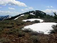
 Snow Peak
Snow Peak - (9,132 feet)
 Haystack Mountain
Snow Peak is located in between Bonneville Peak and Haystack Mountain. As its name suggests, the mountain has snow that lingers into mid-summer. It is a large dome shaped peak that is usually climbed in conjunction with Bonneville Peak. It is climbed often in winter from Pebble Creek Ski Resort.
The route from the north starts from Pebble Creek Ski Resort and a climb to the summit of Bonneville Peak. You have to lose some elevation while hiking down to the saddle between Bonneville Peak and Snow Peak. Then you gain almost all of the elevation back while climbing up the north face to the summit.
Robbers Roost provides an alternative route from the west side of the range. To get there you will have to take the Inkom exit from 1-15. Drive through town and go south under the freeway until you reach US-91. Drive on this road north until you see a sign for Forest Road 035 Robbers Roost. Take this road and drive to the end. It is about five miles distance just to get to the saddle between Snow Peak and Haystack Mountain. From here you can climb up the south ridge of the mountain.
 Haystack Mountain
Haystack Mountain - (9,033 feet)
 Baldy Mountain seen from Sedgwick Peak - by Dean
Haystack Mountain is located south of Snow Peak on the same ridgeline. The mountain has a different appearance when viewed from every direction. From the north it is a sharp and pointed, from the west it has a bold face, from the east it has a long plateau, and from the south it stands above the valley near Lava Hot Springs.
Robbers Roost is the western approach route. To get there you will have to take the Inkom exit from 1-15. Drive through town and go south under the freeway until you reach US-91. Drive on this road north until you see a sign for Forest Road 035 Robbers Roost. Take this road and drive to the end. It is a 5 mile hike just to get to the saddle between Haystack Mountain and Snow Peak. From here you can climb up the north ridge of the mountain. This is a forested ridgeline but is not difficult to follow.
The east side of the mountain is accessed from the Pebble Creek Road off of US-34 not far from Lava Hot Springs. Drive down the road until you see a dirt road signed as Pebble Creek heading west. Follow this road for many miles toward the mountain. Don't drive all the way to the Big Springs Campground. There will be a few side roads that branch off from the main road. There is a bridge that goes over the creek on one of these side roads. Turn here on this high clearance dirt road. It makes a couple switchbacks up the mountainside. Follow this road to the end near a turn around parking area. Haystack Mountain will be to the southwest of the trailhead. It is most easily climbed by ascending to the saddle between Haystack Mountain and Snow Peak and then up the north ridge.
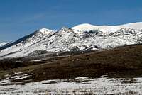
 Baldy Mountain
Southern Peaks
The Southern Peaks are located south of the town of Lava Hot Springs. There are few trails but many dirt roads in this part of the range. Many of these roads are not suitable for passenger vehicles. For that reason, the mountains are not climbed often except by hunters or ATV’s. The highest mountains reach over 9,000 feet and provide a great view of the surrounding area.
 Baldy Mountain
Baldy Mountain - (8,327 feet)
 Sedgwick Peak
Baldy Mountain is located south of the Portneuf River and north of Sedgwick Peak. It is a forested mountain with a dirt road near its summit. Even though Baldy Mountain is lower in elevation than Sedgwick Peak, the views from the summit are just as good.
The mountain is access from the city of Lava Hot Springs. Drive into town and go past the tourist area near the pool and keep driving south for several miles. Look for the cemetery which is the key to finding the road. Turn into the first dirt road to the left of the cemetery. There will be a cattle gate near the beginning that you will have to open. This road is known locally as Bald Mountain Road.
It is a rough and rocky road and the going is slow. There are some side roads but just stay on the main road at all junctions. There will be a flat area that is beneath the north side of Baldy Mountain where several roads converge. One is known as Thunder Mountain Road which is private so don't take that one. If you look around you will see a small sign that goes in the direction toward the mountain that is labeled as Bald Mountain Road with an arrow. Take this road up the mountain. The road goes near the summit and is a short walk from there.
 Sedgwick Peak
Sedgwick Peak - (9,167 feet)
 Petticoat Peak and the Portneuf River
Sedgwick Peak is the second highest mountain in the range and the highest of the southern peaks. It is one of the most prominent unknown peaks in Idaho. Sedgwick Peak is a huge whaleback mountain with a large summit plateau. Mountain surveyors, Bannon and Hodgeson, climbed the mountain in 1914.
There are several dirt roads that go up the mountain. I have been up the dirt road on the east face of the mountain. This road is adequate for 4-wheelers only. Another alternative is from the south near the town of Treasureton. The Cottonwood Creek Road heads north toward the south side of Sedgwick Peak. I have taken this dirt road before and found it too rough and narrow for regular vehicles. You could also hike up this road instead.
The easiest route is from Lava Hot Springs. Drive into town and go past the tourist area near the pool and keep driving south for several miles. Look for the cemetery which is the key to finding the road. Turn into the first dirt road to the left of the cemetery. There will be a cattle gate near the beginning that you will have to open and close. This road is known locally as Bald Mountain Road and isn't suitable for cars and only accessible by a four wheel wheel drive vehicle.
It is a rough and rocky road and the going is slow. There are some side roads but just stay on the main road at all junctions. There will be a flat area that is beneath the north side of Baldy Mountain where several roads converge. One is known as Thunder Mountain Road which is private so don’t take that one. If you look around you will see a small sign that goes in the direction toward the mountain that is labeled as Bald Mountain Road with an arrow. Take this road that goes up the mountain. After reaching Baldy Mountain, the road gets narrow and is steep in many places. Some of these spots require good driving skills.
There are several microwave towers on the summit that can be seen from a long distance away. A fire lookout was built on a concrete base topped by a frame cab. Construction of it began in 1973 and wasn't completed until 1977. On a clear day the view is very extensive including all the southern peaks and several other mountain ranges across the valley. The point located to the south is Peak 8,724. There is more than one benchmark on the summit. I remember seeing one that was labeled as Baldy 1963.
 Petticoat Peak
Sub-Ranges
There are two sub-ranges to the Portneuf Range. The Pocatello Range are the low elevation hills located west of the higher mountains. It was named for its proximity to Pocatello. The Fish Creek Range is east of the main crest of the Portneuf Range. It is slightly lower in elevation but is similar in appearance.
Pocatello Range - (6,791 feet)
The Pocatello Range is located southeast of the city of Pocatello. It consists of several lower elevation mountains. The highest mountain in the range is Chinks Peak and it is usually referred to now as Chinese Peak. It was named for the Chinese workers who helped build the railroad and work on the mines near Pocatello. There is a dirt road that goes to its summit. A fire lookout was built in 1962 but was destroyed in 2003. There are dirt roads in the range used by motorcycles, four wheelers, mountain bikers, and runners. Other named mountains in the range include Moonlight Mountain and Camelback Mountain.
 Harkness Canyon southwest of Haystack Peak
Fish Creek Range - (8,032 feet)
The range was named after Fish Creek which is a tributary of the Portneuf River. The range parallels the Portneuf Range on the east. It offers similar rugged terrain but no trails. Petticoat Peak is the highest and only named summit in the Fish Creek Range. It is located 4 miles northeast of Lava Hot Springs. The shortest route to the top is the west face from US-34. You can choose to climb anywhere up the face which is covered in sagebrush and trees. It is rated class 2. The benchmark on the summit is labeled as Lund, 8,032 feet. The mountain can also be climbed from the southeast ridge directly off of US-30 near Fish Creek Divide. This is a longer route than the west face. The Fish Creek Range is the Portneuf Range's little sister so it also crosses over the Portneuf River and continues to parallel the southern peaks of the range near Sedgwick Peak.
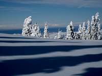
 Bonneville Peak view south in winter - by pioneerclimber
Rock Climbing
There are several climbing areas in and around the Portneuf Range. The type of rock varies from dark basalt to limestone with mixed granite intrusions. Developed areas offer solid rock and are climbed often. The undeveloped areas tend to have some loose rock so wear a helmet. Ross Park is well known but there is little information available on the other areas. I'll try to explore the rest of the range later.
Ross Park
While driving down I-15 you will notice the short cliffs and walls on both sides of the road. Ross Park is located south of Pocatello on the right side of Fourth Street or the left side of Second Street. The climbs vary in length from 25 feet to 50 feet. It is an excellent place to climb if you are in the area. The Shady Side (Fourth Street) provides climbing for the 5.5 - 5.11 climbers on friction faces and cracks and is good for toproping. The Sunny Side (Second Street) has higher walls and excellent routes rated around 5.9 and some aid routes. The Pocatello Pump is a climbing contest held every fall on the basalt crags of Ross Park's Sunny Side and Shady Side.
Robbers Roost Crags
Robbers Roost is beneath Haystack Peak. To get there you will have to take the Inkom exit from 1-15. Drive through town and go south under the freeway until you reach US-91. Drive on this road north until you see a sign for Forest Road 035 Robbers Roost. Take this road and drive to the end. You will be able to see the crags on the left side just west and underneath of Haystack Peak. The hikers trail goes to the saddle between Haystack and Snow Peak. Leave the trail after 1.5 miles and hike up to the base of the cliffs.
Harkness Canyon
Harkness Canyon is on southwest side of Haystack Peak. Travel time from Pocatello is 40 minutes. There is a signed dirt road for Harkness Canyon. Stay on the main road at all junctions away from private property. Although the approach is a bit long, 1.5 hours from the end of the road, the climbing is worth the effort. These crags range from 50 to 300 feet in height and are vertical to slightly overhanging. Expect a strenuous hike to the base of the cliffs in the upper portion of the canyon. The area itself is not visited often, but offers good trad climbing.
 Inman Yurt
Winter Recreation
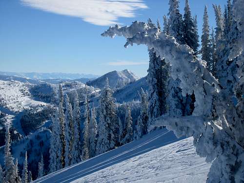
Pebble Creek Ski Area
 Inman Yurt
Pebble Creek Ski Area is located east of Pocatello and four miles south of the city of Inkom. Pebble Creek's runs are on the northwestern slope of Skyline Peak and Bonneville Peak, the highest in the Portneuf Range. The lift-served summit maximum elevation is 8,560 feet, with a vertical drop of 2,200 feet. Accessing the summit of Bonneville Peak is allowed, 711 vertical feet higher, giving a vertical drop of 2,911 feet total.
The area opened in 1949 as Skyline Ski Area with two rope tows and a warming hut. A Poma lift was installed in 1958, and another in 1960. The first chairlift was installed in 1966 along with steeper terrain, and the current day lodge was built in 1968. The area was sold in 1978 and 1979 to the Pebble Creek Land Company, which changed the area's name to Pebble Creek. The CTEC triple chairlift was added in 1980, with additional terrain, and the area was sold again in 1981 to Pebble Creek Ski Area Limited., a group of local investors. In 2001, the old Minor-Denver double chair was replaced with a triple which extended toward the summit an additional 200 vertical feet.
Currently, there are 3 chairlifts: two triples and a double. Pebble Creek has 1,100 acres of skiable terrain, rated at 12% beginner, 35% intermediate, and 53% advanced. The average annual snowfall is 250 inches a year. Snow making machines was added in the lower areas of the mountain in the 1990s. Pebble Creek is open from December through April. Night skiing is available from January through March 10 on Friday and Saturday.
Portneuf Range Yurt System
 Bonneville Peak in winter - by merrill
There is a yurt system in the Portneuf Range. The yurt system is made possible through volunteer work and the cooperation between the Idaho State University Outdoor Program, Bear Lake Backcountry Skiers, Caribou National Forest, Bureau of Land Management and private landowners. Each yurt is outfitted with a wood stove, Coleman white gas cooking stove and lantern, pots, axe and bunk beds. The lower yurts can be reached by families and beginning skiers/snowshoers, but experts will appreciate the upper ones. Idaho State Park & Ski stickers are required for parking at the Inman Canyon and Bloomington Canyon trailhead. The Park and Ski passes are available at local outdoor retail stores and the ISU Outdoor Program Office.
Here is the list of Yurts from beginner to intermediate level: (1) Catamount Yurt: easy. (2) Skyline Yurt: beginner to intermediate yurt. (3) Inman Yurt: moderate to intermediate. (4) Jackson Creek, Inkom Pass Yurt: advanced intermediate to difficult. (5) McNabb Point Yurt: advanced.
Route descriptions, maps and a yurt manual are provided when making reservations for the yurts. Even though route information is provided, it is strongly advised that you go on organized tours before undertaking your own tour. Adventure trips to the yurts are offered through the Idaho State University Outdoor Program office and through commercial outfitters. Please understand that it is the responsibility of the yurt user to locate the yurt. Yurt rental fees will not be refunded if you cannot locate the yurt. Reservations are required. For information on reservations and rental prices please contact the Idaho State University Wilderness Rental Center at (208) 282-2945. For yurt system details, contact ISU Outdoor Program at (208) 282-3912.
 Bonneville Peak
Area History
 Pebble Creek
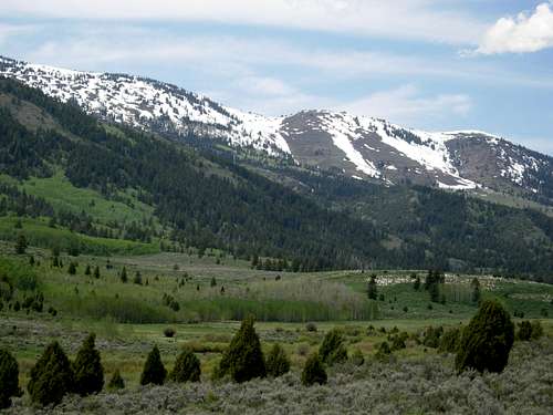 Snow Peak seen from the valley to the east
The ancestral lands of the Shoshone and Bannock Indians included parts of Montana, Idaho, Yellowstone National Park, Northern Utah, Nevada, and California. The Shoshone and Bannock tribes were granted 1.8 million acres in southeastern Idaho under the Fort Bridger Treaty of 1868. After the war, the Bannock moved onto the Fort Hall Indian Reservation, where they live with the Shoshone and Lemhi Indian tribes. The reservation is located near the cities of Pocatello and Blackfoot. Pocatello is the largest city in the area. The name Pocatello comes from an Indian chief of the Shoshone tribe who granted the railroad a right-of-way through the Fort Hall Indian Reservation. The area now occupies about five hundred and forty-four thousand acres.
The Portneuf River rises in western Caribou County, approximately 25 miles east of Pocatello. It then flows south as it passes westward around the southern end of the range, and then turns north to flow between the Portneuf Range to the east and the Bannock Range across the valley. The water then goes northwest through downtown Pocatello and enters the Snake River at the northeast corner of American Falls Reservoir. Precipitation in this region shows a moderate peak in late spring, and flows in the river are highest during spring runoff and following occasional intense summer storms. The river provides recreation in the area especially for local fisherman. The valley of the Portneuf provided the route of the Oregon Trail and California Trail in the 1800's.
Hudson's Bay Company established one of the first permanent settlements at Fort Hall in 1834, which is only a few miles northeast of Pocatello. When over trapping and a change in fashion to silk put an end to the fur trade, Fort Hall became a supply point for immigrants traveling on the Oregon trail. The discovery of gold in Idaho in 1860 brought the first group of settlers to the region. The area became an important meeting place for transportation of goods and freight. In 1877, Jay Gould of the Union Pacific Railroad acquired and extended the Utah and Northern Railway, which had previously stopped at the Utah border, into Idaho through Portneuf Canyon. Pocatello Junction was founded as a stopping place along this route during the gold rush.
After the gold rush was over, the settlers who remained turned to agriculture. By 1882, the first residences and commercial development appeared in Pocatello. With the help of irrigation from the nearby Snake River, the region became a large supplier of potatoes, grain and other crops. Residential and commercial development gradually appeared. On July 3, 1890, Idaho became the 43rd state in the United States. Idaho State University is located in Pocatello. It was established in 1901 as the Academy of Idaho. Through the years it has been renamed several times. In 1963, it received its current name of Idaho State University. There are over 12,000 students that attend the university. It is among the fastest growing of the four higher education institutions in state of Idaho.
The city of Lava Hot Springs is located approximately 30 miles southeast of Pocatello. It is one of Idaho’s historic resort areas. Lava Hot Springs centers around the renowned geothermal pools that were used for centuries by Native Americans and were given to the state in 1902 as a health and recreation facility. These soaking pools, along with the geothermally-heated Olympic swimming pool complex, are the reason for the town’s resort status. The water is discharged into the Portneuf River after it is used. Local businesses, primarily hotels and motels, divert geothermal water from hot springs, and from one deep and several shallow wells for space heating and for soaking tubs and pools for their guests. The majority of these sites are located within 200 feet of the Portneuf River.
 August Snowstorm
When to Climb
 Bonneville Peak Clouds
 View northwest from Pebble Creek - by TimB
The Portneuf Range can be climbed all year. Most people hike and climb in these mountains from May through October. The mountains are dry during summer and all snow will be melted. During spring, snow patches will last into late May and June. Hunting season takes place in Fall and people will be in most areas of the range so use caution during this time. Fall colors last from mid-September to mid-October.
Winter is a nice time to visit the range. Many people come here to ski at Pebble Creek or use the Yurt System. The lower elevation peaks around Pocatello are climbed often in winter. Snow melts early from the Pocatello Range and foothills. Bonneville Peak and Snow Peak are climbed by many people in winter. There is a yurt located near the south ridge of South Putnam Peak that can be used. Baldy and Sedgwick would be more difficult to climb in winter because of the long approaches on dirt roads.
The city of Pocatello is the largest city in the area. It is located at an elevation of 4,448 feet. It has a four-season climate with clear, sunny and dry days and an occasional thundershower. The city receives less than 15 inches of precipitation annually. Summers are dry and warm with a July average temperature at 72.4 degrees. The average daily temperature during the winter months is 35.4 degrees.
Weather Forecast for the cities of Pocatello and Lava Hot Springs
 Haystack Mountain seen from the east
Red Tape
The Northern Peaks of the range are administered by Fort Hall Indian Reservation. Permission must be granted to climb here.
The Central Peaks of the range and Pebble Creek Ski Area are administered by Caribou-Targhee National Forest.
The Southern Peaks of the range are administered by the State of Idaho and BLM. There is some private land on both sides of the valley including south of Lava Hot Springs. Private Roads are usually posted so it should be easy to determine access to certain areas.
The Pocatello Range and Fish Creek Range are administered by the BLM.
Contact Information:
1) Caribou-Targhee National Forest Headquarters Office - 1405 Hollipark Drive Idaho Falls, Idaho 83401. Phone: (208) 524-7500
2) Pocatello Office - 4350 Cliffs Drive in Pocatello, Idaho 83204. Phone: (208) 236-7500
3) Shoshone-Bannock Tribes - P.O. Box 306 Pima Drive Fort Hall, Idaho, 83203. Phone Number: (208) 478-3857
 Bonneville Peak
Camping
 Pebble Creek Road
Big Springs Campground
Big Springs Campground is located about 16 miles north of Lava Hot Springs, Idaho in Pebble Creek Drainage. The campground is north of Lava Hot Springs and west of Bancroft. Single family units are $10, two family units are $20 per night. There is no electricity/water/sewer site hook-ups at this campground. A fee of $5 for extra vehicles will be collected. ATV's or ORV's allowed on designated trails only. No riding in the campground. From Lava Hot Springs, go north on old Highway 30, which is a paved highway, for about 9 miles to Pebble Creek Road. This is also known locally as "Mikes Place" or "Whisky Mikes". Turn left and west across railroad tracks on forest road #036 which is gravel. Stay on this road and go 7 miles to Big Springs Campground.
Pebble Guard Station
Pebble Guard Station is located at the base of Bonneville Peak along Pebble Creek, a tributary of the Portneuf River. The main room serves as the kitchen and sleeping room and there are shower facilites. Cabin amenities include a wood stove, propane heater, oven, small fridge, two bunk beds, chairs, and table. Adjacent to the cabin, is a single stall vault toilet building, fire ring, and picnic table. In winter, the cabin can be reached by a groomed snow machine route about four miles from the closed gate on Pebble Creek Road. For questions contact the Westside Ranger District at 208-236-7500 or visit the office at 4350 Cliffs Drive, Pocatello, Idaho 83204. Call four days prior to your arrival to confirm the security combination. From Lava Hot Springs, go north on old Highway 30, which is a paved highway, for about 9 miles to Pebble Creek Road. This is also known locally as "Mikes Place" or "Whisky Mikes". Turn left and west across railroad tracks on forest road #036 which is gravel. Stay on this road and go toward Big Springs Campground. The cabin will be about one half mile before the campground.
Pocatello KOA
 Skyline Peak is located north of Bonneville Peak
This campground, surrounded by mountains, offers grassy, shaded tent sites, with fire pits, and 85-foot-long, extra-wide RV pull thru sites. There are also rooms called Kamping Kabins available. Amenities include 30 Amp service, firewood, wireless Internet , and snack bar. Pocatello’s Ross Park features a swimming pool and sporting activities and hosts the Pocatello Zoo, the Bannock County Historical Museum and an 1800s fur-trading post. From I-15 take Exit 71 Pocatello Creek Road. Drive East for 1.25 miles to the KOA. If coming from I-86 west, take Salt Lake Junction to Pocatello Creek Exit 71. Then drive east 1.25 miles to the KOA.
Lava Hot Springs Rivers Edge RV Park
This place in Lava Hot Springs is open year-round. Amenities include: electrical hookups, mini-mart and gift shop. Showers are additional. Pets welcome. Nearby attractions: Trails for snowmobiles, skiing, hiking, hot springs, golfing, wagon rides. The fee for one day is: $10.00 - $22.00. It is located at 101 W. Portneuf Lava Hot Springs, Idaho 83246. Phone: (208) 776-5209.
[img:353372:aligncenter:medium:Skyline Peak is located north of Bonneville Peak]
Peak Lists
The Portneuf Range has mountains over 9,000 feet in elevation. They are located east and southeast of the city of Pocatello, Idaho. All peaks by their standard routes are rated class 1-2 hiking. There are also three prominence peaks in the range. See lists below.
Idaho County Highpoints List
This is a great list of Idaho County Highpoints made by SP member SawtoothSean. Bonneville Peak is the highpoint of Bannock County.
Idaho Prominence Peaks List
This website has information for Idaho Prominence Peaks. This includes Sedgwick Peak, Bonneville Peak, and South Putnam Mountain.
| PORTNEUF RANGE | ||
| Mountain | Elevation (Feet) | Summitpost Page |
|---|---|---|
| 9,000 foot Peaks | ||
| Bonneville Peak | 9,271 | Page |
| Sedgwick Peak | 9,167 | Page |
| Snow Peak | 9,132 | |
| Haystack Mountain | 9,033 | |
| 8,000 foot Peaks | ||
| South Putnam Mountain | 8,949 | |
| "Red Peak" | 8,838 | |
| Mount Putnam | 8,810 | |
| "Topaz Peak" | 8,425 | |
| Baldy Mountain | 8,327 | |
| "Bullwhacker Hill" | 8,140 | |
| "Downey Peak" | 8,057 | |
| Petticoat Peak | 8,032 | |
| 7,000 foot Peaks | ||
| Thatcher Hill | 7,980 | |
| "East Marsh Peak" | 7,941 | |
| Cottonwood Peak | 7,940 | |
| "Inkom Peak" | 7,936 | |
| Twin Knobs | 7,823 | |
| "West Marsh Peak" | 7,816 | |
| "Bancroft Mountain" | 7,774 | |
| "Ninemile Peak" | 7,664 | |
| "Whistle Mountain" | 7,433 | |
| "Yago Ridge" | 7,402 | |
| Dry Hollow Mountain | 7,220 | |
| "Virginia Peak" | 7,180 | |
| "Smith Canyon Peak" | 7,135 | |
| "Arimo Peak" | 7,102 | |
| "Inman Peak" | 7,058 | |
| Peaks below 7,000 feet | ||
| Chinks Peak (Chinese Peak) | 6,791 | |
| Treasureton Hill | 6,705 | |
| Moonlight Mountain | 6,639 | |
| Camelback Mountain | 6,586 | |
| Heart Mountain | 6,322 | |
| Mount Moh | 6,244 | |
| Cedar Hill | 6,134 | |
| Buckskin Benchmark | 6,080 | |
| Peak 5779 (Lava Hot Springs) | 5,779 | |
| PORTNEUF RANGE MOST PROMINENT PEAKS | |||
| Mountain | Elevation (Feet) | Ranking in Idaho | Prominence (Feet) |
|---|---|---|---|
| Sedgwick Peak | 9,167 | 12th | 3,637 |
| Bonneville Peak | 9,271 | 18th | 3,391 |
| South Putnam Mountain | 8,949 | 59th | 2,349 |
| PORTNEUF RANGE COUNTY HIGHPOINTS | ||
| Mountain | County | Easiest Route |
|---|---|---|
| Bonneville Peak | Bannock | From Pebble Creek : Class 2 |
Books
Idaho: A Climbers Guide: Climbs, Scrambles, and Hikes
By Tom Lopez. The book has four pages on the Portneuf Range. It describes the mountains and access roads in each area.
External Links
Pocatello Rock Climbing
This is an online guide to rock climbing in and around Pocatello including the areas of Ross Park.
Pocatello Skiing and Snowshoeing Trails
This is an online guide to cross-country skiing and snowshoeing in the Portneuf Range and Pocatello area.
Bannock County Historical Museum
This museum is located on 3000 Alvord Loop in Pocatello. It focuses on the history of Bannock County with exhibits of items relating to Pocatello's early railroad history and Native American items that tell about the Shoshone-Bannock tribes from the area.