
-
 27237 Hits
-
 90.66% Score
-
 34 Votes
|
|
Mountain/Rock |
|---|---|
|
|
42.76329°N / 112.14104°W |
|
|
Bannock & Caribou |
|
|
Hiking, Skiing |
|
|
Spring, Summer, Fall, Winter |
|
|
9271 ft / 2826 m |
|
|
Overview
 Bonneville Peak
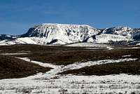
Bonneville Peak is the highest summit in the Portneuf Range in southeast Idaho. It is also the highpoint of Bannock County. Bonneville Peak has over 3,400 feet of prominence. It is sought after by people wanting to climb the most prominent peaks in Idaho. Bonneville Peak is located between Marsh Valley to the west and Portneuf Valley to the east. The Portneuf Range runs north to south for sixty miles from Pocatello to Cache Valley north of Preston. Portneuf is a French word that is pronounced as "port-noof".
The mountain range was named after the Portneuf River. The river was named after a member of Peter Skene Ogden's trapping party who was killed by Indians in 1825. The valley of the Portneuf provided the route of the Oregon Trail and California Trail in the 1800's. After the discovery of gold in Idaho, it became a significant stage route for the transportation of people and goods. In 1877, the valley was used as the route of the Utah and Northern Railway, and was the first railroad in Idaho.
There may be more ascents of Bonneville Peak made in winter than summer because of the easy access during that time. Many hikers also choose to approach the mountain from the ski area after the snow has melted. The standard route to the top ascends the west face from Pebble Creek Ski Area. This makes it a short and steep hike between five to seven miles round trip. There are others routes to choose from for those looking for a longer hike. The mountain can also be approached from the southwest and east side. From Robbers Roost Trailhead, the route goes up to a saddle located north of Haystack Mountain. Then it follows the south ridge of Snow Peak, which is the large dome shaped peak near Bonneville Peak. The distance between the two peaks is about a mile separated by a saddle. This is the longest route to the summit and is fifteen miles round trip.
Pocatello is the largest city in the area and one of the largest cities in Idaho overall. The name Pocatello comes from an Indian chief of the Shoshone tribe who granted the railroad a right-of-way through the Fort Hall Indian Reservation. The reservation is located at the northern end of the Portneuf Range. The city of Inkom is thirteen miles southeast of Pocatello below Bonneville Peak. The area was originally named "Ingacom" meaning "Red Hare". The Shoshone Indians called it this because a rock formation on the east side of Inkom resembled a rabbit. Sometime before 1930, vandals knocked off the ears of the rabbit. The rest of the rock formation can still be seen today. Similarly, the nearby creek was called "Rabbit Creek". It was later changed to Rapid Creek for the swiftness of the water.
Bonneville Peak was named after Benjamin Louis Eulalie de Bonneville. He was a French-born officer in the United States Army. He was also a fur trapper and explorer of the American West. He is known for his expeditions to Oregon and the Great Basin, and for blazing portions of the Oregon Trail. Bonneville joined together with mountain man Joseph Rutherford Walker in 1833, and their party made an early exploration of Yosemite. They returned by a different route and discovered Walker Pass in the Southern Sierra. Lake Bonneville and the Bonneville Salt Flats in Utah would later be named after Benjamin Bonneville. He explored throughout much of the Snake River area from 1834 to 1836. He became well known during his lifetime by an account of his explorations written by Washington Irving. The result of this was the book, The Adventures of Captain Bonneville, U.S.A., in the Rocky Mountains and the Far West, published in 1837.
Getting There
 Bonneville & Snow Peak
Pebble Creek Ski Area Trailhead:
Drive on Interstate-15 south of Pocatello. Take (exit 57) at the city of Inkom. Turn south onto Old Highway 91. Follow signs on this road leading the way toward Pebble Creek Ski Area. Turn left on Inkom Road and drive north for 0.3 mile. Then turn right on Green Canyon Road. This is also known as Forest Road 210. Follow this windy paved road with numerous switchbacks for 4.3 miles. The road is steep and narrow in places but accessible to all vehicles. It ends at a large dirt parking area at the bottom of the ski lifts. The trailhead is located at 6,680 feet elevation.
Robbers Roost Trailhead:
Drive on Interstate-15 south of Pocatello. Take (exit 57) at the city of Inkom. Turn south onto Old Highway 91. Drive underneath the I-15 overpass and continue going south for 6 miles. Turn left onto Robbers Roost Road. Drive on this dirt road for 2.3 miles to the small parking area on the left. There is room for only a few vehicles here. This trailhead is located at 5,500 feet elevation. If coming from the south, Drive on Interstate-15 near McCammon. Take (exit 47). Turn right onto Highway 30 East which goes toward Lava Hot Springs / Soda Springs. Drive for 0.8 mile and then turn left onto South Old Highway 91. Drive north for 3.4 miles. Turn right onto a dirt road named Robbers Roost Road and drive for 2.3 miles to a small parking area on the left. There is room for only a few vehicles here.
Big Springs Campground Trailhead:
Drive on Interstate-15 near McCammon. Take (exit 47) and turn onto Highway 30 East. Drive for 12.8 miles. At the east side of the city of Lava Hot Springs, turn left onto Old Highway 30. Drive for 9 and then turn left onto Pebble Creek Road. This road is also known as County Road 740. After 0.6 mile turn left on Taylor Road. Follow Taylor Road for about 250 feet and then turn right. Now you are on National Forest Road 36. Follow this road for 6 miles. The road ends at Big Springs Campground at 6,400 feet elevation. If you have a car, you'll want to park at the campground but high clearance vehicles can continue farther. Before you get to the campground, there will be dirt road on the right. It leads into Big Canyon. You can drive up the road for at least another mile depending on how far your vehicle can make it. At the end is a circular parking area and turn around point.
Routes Overview
 Bonneville Peak Bonneville Peak |  Skyline Peak Skyline Peak | 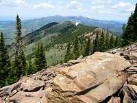 Skyline Peak View North Skyline Peak View North |
Pebble Creek Ski Area Route
From the parking area, go to the left side of the ski resort buildings and start walking up the road. Soon after that the ski road switchbacks will begin. There are over twenty switchbacks. Some of you may find the ski road to be monotonous and decide to just go straight up the mountain. I left the switchbacks and started hiking up near the two main ski lifts, named Skyline Lift on the left and Sunshine Lift on the right. The area on the right side near the ski fence boundary had less brush than the left side so that is the way I went. After climbing 1,200 feet you'll reach the top of Sunshine ski lift near 7,800 feet.
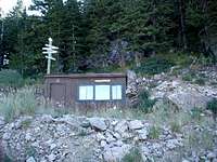
The road makes a long curve between the lower section of switchbacks and the upper section. I did end up following the upper section of switchbacks since it seemed easier than hiking off-trail here. At the end of the switchbacks is the top of Skyline Lift at 8,300 feet elevation. Continuing a little farther south from the ski lift is where you will find a small brown ski patrol shack. When I was there the door was unlocked and inside was a log book for any visitors to sign. Also near the shack was a humorous sign pointing directions to various places.
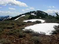
The ski shack is a key landmark on the hike. There is a climbers trail located directly behind it. This trail will make climbing the mountain much easier so it is worth finding. The trail is steep but in good condition. It will lead to a boulder field below the west face of Skyline Peak, 9,119 feet. There are a few cliffs to negotiate here by going either right or left. Once you reach the top of Skyline Peak, you will be on the main ridge of the Central Portneuf Range. Hike south along this mellow ridgeline for about a half mile to the summit of Bonneville Peak, 9,271 feet. The summit has a cairn and a little to the north is a small building. At first, I thought it looked like an outhouse but it's not. Dean said it most likely housed a repeater for a local rancher but it had fallen into disrepair.
The view from the top includes several ranges in southeast Idaho. To the north are Mount Putnam and South Putnam Mountain near Fort Hall Indian Reservation. To the south is Snow Peak and Haystack Mountain. Farther south is Sedgwick Peak and Baldy Mountain. To the northwest is the Pocatello Range including Camelback Mountain and Midnight Mountain. To the west is the city of Inkom and I-15. The northern peaks of the Bannock Range are on the other side of Marsh Valley. Scout Mountain and Old Tom Mountain are the highest peaks to the southwest. To the east is Portneuf Valley and the Cheseterfield Range near Chesterfield Reservoir. On a clear day, I was able to see the Lost River Range and Lemhi Range off in the distance to the northwest.
(Distance is 5 miles round trip with 2,600 feet elevation gain). If you walk the entire ski road the hike will be two miles longer.
 Bonneville Peak North Ridge Bonneville Peak North Ridge | 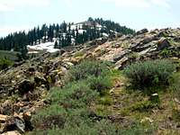 Bonneville Summit Ridge Bonneville Summit Ridge |  Snow Peak & Haystack Mountain Snow Peak & Haystack Mountain |
Robbers Roost
Robbers Roost has an interesting name and history. The area was named for a hiding place near McCammon where travelers were robbed at gunpoint. Then the robbers would disappear in the dark lava rocks of the canyon where they had less of a chance at being caught. Today, there is a hikers trail up Robbers Roost Canyon. The trail follows Robbers Roost Creek to 6,300 feet elevation where it makes a right turn onto the ridgeline above the south side of the canyon. Then the trail turns back east again past Point 6922. The trail goes beneath the west face of Haystack Mountain near 7,700 feet. Then the trail goes northeast toward the saddle on the ridge between Point 8424 and Point 8702. It is a five mile hike from the trailhead to the saddle between Snow Peak and Haystack Mountain. From here you can hike up the south ridge of Snow Peak gaining 900 feet to the summit. There is a descent down the other side of the peak to a saddle losing about 700 feet along the way. Then the route ascends the south ridge of Bonneville Peak. This is the longest route to the summit. You must re-climb Snow Peak on the way back. Add two miles and eight hundred feet gain if you are also hiking to Haystack Mountain.
(Distance is 15 miles round trip with 4,300 feet elevation gain).
Three Peaks Traverse
 Haystack Mountain
This traverse includes Bonneville Peak, Snow Peak and Haystack Mountain. In my opinion, this is the best way to climb all three peaks in one day. The only thing that is required is having two vehicles. Most people will probably not have this option unless you live near Pocatello or know someone that lives nearby. The easiest way to do this is from north to south because you will be starting at a higher elevation at Pebble Creek. The hike can be done in either direction though. Follow the standard route from Pebble Creek up to Bonneville Peak. Then traverse up and over Snow Peak, 9,132 feet. Follow the ridge south to a saddle north of Haystack Mountain. From the saddle the mountain has an appearance similar to a haystack. When viewed from the valley, it looks like a flat top. Now follow the north ridge for about a mile to the summit of Haystack Mountain, 9,033 feet. Retrace your steps back to the saddle and then hike down the Robbers Roost trail to the trailhead.
(Distance north to south is 12 miles total with 4,100 feet elevation gain).
From Big Springs Campground
This route is located on the east side of the mountain. There are no established trails in this area so this route is not done as often as the others already mentioned. Any vehicle can get to the campground when it is dry. A dirt road continues into Big Canyon for those of you with a high clearance vehicle. Follow this side road for another mile or so to 6,650 feet elevation. From here, hike west and follow the creek. The creek will fork ahead. Take the right fork which keeps following Big Canyon. Hike up this fork until you are beneath the east ridge of Snow Peak around 7,000 feet elevation. You have two options from here.
There is a small hunter's trail that goes all the way up Big Canyon. So the first option is to follow that trail up to the ridge west of Point 8702. Notice that the route from Robbers Roost comes up from the other side of the ridge to this point. It is about 1.5 miles from here to Snow Peak and then another mile to Bonneville Peak. The second option is to climb up the east ridge of Snow Peak from the fork. This route gains over 2,000 feet to Snow Peak in a short distance thus making it the more difficult of the two options.
(Distance is 8 to 12 miles round trip with 3,500 feet elevation gain).
Pebble Creek Ski Area
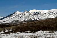
 Bonneville Peak in winter
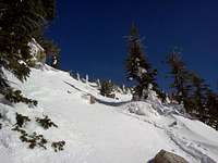 Bonneville Peak in winter
Pebble Creek Ski Area is located southeast of Pocatello near the city of Inkom. Pebble Creek's runs are on the northwestern slope of Skyline Peak and Bonneville Peak. The lift-served summit maximum elevation is 8,560 feet, with a vertical drop of 2,200 feet. Accessing the summit of Bonneville Peak is allowed, 711 vertical feet higher, giving a vertical drop of 2,911 feet total.
The area opened on January 20, 1949 as Skyline Ski Area with two rope tows and a warming hut. A Poma lift was installed in 1958, and another in 1960. The first chairlift was installed in 1966 near steeper terrain, and the current day lodge was built in 1968. The area was sold in 1978 and again in 1979 to the Pebble Creek Land Company , which changed the area's name to Pebble Creek. The CTEC triple chairlift was added in 1980, with additional terrain, and the area was sold again in 1981 to Pebble Creek Ski Area Limited., a group of local investors. In 2001, the old Minor-Denver double chair was replaced with a triple which extended the lift-served summit an additional 200 vertical feet.
The ski area currently has 3 chairlifts: two triples and a double. Pebble Creek has 1,100 acres of skiable terrain that is rated at 12% beginner, 35% intermediate, and 53% advanced. The average annual snowfall is 250 inches a year. Snow making machines was added in the lower areas of the mountain in the 1990s. Night skiing is available from January through March 10 on Friday and Saturday. Pebble Creek is normally open from mid-December through mid-April depending on snow conditions. After that, the area remains open to hikers and mountain bikers.
When to Climb
 Ski Patrol Shack
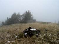 Summer Snowstorm
For hikers, the time frame is from May through November.
For skiers, the season is from December through April.
I found snow above 8,000 feet elevation on the west face of the mountain in late May. Bonneville Peak summit ridge was mostly dry. It did seem like nearby Snow Peak and Haystack Mountain had more snow even though they are both lower. Above Pebble Creek, the mountain was fairly shaded in the morning so it wasn't too warm.
It may be quite hot during summer for some people. That being said, it can also snow at any time of the year. Don't stay on the summit ridge for very long if rain and thunderstorms are threatening. Bonneville Peak is well forested except on the ridgeline which is in the open. This is a dry mountain once all the snow has melted in summer so you'll need to carry all water with you. Expect to see mosquitoes and flies from mid-June through July. I saw some deer on the mountain and other signs that wildlife is abundant in this area. The Portneuf Range is popular during hunting season in autumn, from September through October, especially the east side of Bonneville Peak. If you do hike during this time, use caution and wear bright colors.
Red Tape
No red tape from May through November.
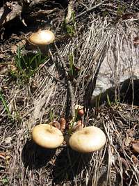 Mushrooms
A Pebble Creek Ski Area Pass is needed if you are accessing Bonneville Peak from the ski resort in winter. An adult pass cost $40 a day. A senior pass for anyone over age 66 cost $26 a day. An annual pass may also be purchased.
For more information on skiing, here is the website for Pebble Creek Ski Resort.
The Central Peaks of the Portneuf Range are administered by Caribou-Targhee National Forest.
| Caribou-Targhee NF Office | Pocatello Westside Ranger District |
| 1405 Hollipark Drive | 4350 Cliffs Drive |
| Idaho Falls, Idaho 83401 | Pocatello, Idaho 83204 |
| Phone: (208) 524-7500 | Phone: (208) 236-7500 |
Camping
There are no campgrounds located on the road leading to Pebble Creek Ski Resort. There are campgrounds on the other side of the mountain. They are located east of McCammon and north of Lava Hot Springs. Note that the area on the east side near Big Springs Campground is also known as Pebble Creek. Don't confuse this with the ski area on the west side. If all campgrounds are full of if you don't feel like camping, there are motels in Lava Hot Springs and Pocatello.
Backcountry Camping Regulations:[img:852054:alignright:small:Mushrooms]
Backcountry camping is allowed in this mountain range. Camping is free in these areas as long as you select a site outside a developed campground and follow the rules. Practice leave no trace techniques. You must camp 200 feet away from any road, trail, or water source. The camping limit in one spot is 16 days.
Big Springs Campground
Big Springs Campground is located about 16 miles north of Lava Hot Springs, Idaho in Pebble Creek Drainage. The campground is north of Lava Hot Springs and west of Bancroft. Single family units are $10, two family units are $20 per night. There is no electricity hook-ups or water at this campground. A fee of $5 for extra vehicles will be collected. ATV's or ORV's allowed on designated trails only. No riding in the campground. From Lava Hot Springs, go north on old Highway 30, which is a paved highway, for about 9 miles to Pebble Creek Road. This is also known locally as "Mikes Place" or "Whisky Mikes". Turn left and west across railroad tracks on forest road #036 which is gravel. Stay on this road and go 7 miles to Big Springs Campground.
Pebble Guard Station
Pebble Guard Station is located not far southeast of Big Springs Campground. This cabin is a nice place to stay costing $40 a night. The main room serves as the kitchen and sleeping room and there are shower facilites. Cabin amenities include a wood stove, propane heater, oven, small fridge, two bunk beds, chairs, and table. Adjacent to the cabin, is a single stall vault toilet building, fire ring, and picnic table. In winter, the cabin can be reached by a groomed snow machine route about four miles from the closed gate on Pebble Creek Road. For questions contact the Westside Ranger District at 208-236-7500 or visit the office at 4350 Cliffs Drive, Pocatello, Idaho 83204. Call four days prior to your arrival to confirm the security combination. From Lava Hot Springs, go north on old Highway 30, which is a paved highway, for about 9 miles to Pebble Creek Road. This is also known locally as "Mikes Place" or "Whisky Mikes". Turn left and west across railroad tracks on forest road #036 which is gravel. Stay on this road and go toward Big Springs Campground. The cabin will be about one half mile before the campground.
Pocatello KOA Campground
This campground, surrounded by mountains, offers grassy, shaded tent sites, with fire pits, and 85-foot-long, extra-wide RV pull thru sites. There are also rooms called Kamping Kabins available. The amenities in those Kabins include 30 Amp service, firewood, wireless internet and snack bar. From Interstate-15 take Exit 71 onto Pocatello Creek Road. Drive East for 1.25 miles to the KOA.
Lava Hot Springs Rivers Edge Campground
This place in Lava Hot Springs is open year-round. The amenities include campsites, electrical hookups and mini-mart. Showers are additional. Pets are welcome. The nearby attractions include trails for hiking, skiing, swimming pools and the famous hot springs. The fee for one day is between $10.00 - $22.00. It is located at 101 West Portneuf Lava Hot Springs, Idaho 83246. Phone: (208) 776-5209.
Books
Idaho: A Climbers Guide: Climbs, Scrambles, and Hikes
By Tom Lopez. This book has four pages on the Portneuf Range. It describes Bonneville Peak and access roads in the range.
Trip Reports
(1) Bonneville Peak - Aug 23, 2006 - Dennis Poulin hiked Bonneville Peak from Pebble Creek Ski Area.
(2) Bonneville Peak - June 15, 2002 - IdahoSummits trip report of Bonneville Peak and Skyline Peak from Pebble Creek.