
-
 33595 Hits
-
 98.03% Score
-
 76 Votes
|
|
Area/Range |
|---|---|
|
|
40.34120°N / 111.6037°W |
|
|
Ice Climbing |
|
|
Winter |
|
|
6000 ft / 1829 m |
|
|
Overview
Provo Canyon is the most well known ice climbing area in Utah. It is located east of the city of Provo in Utah Valley. This is south of Salt Lake City in the Southern Wasatch Mountains. Many visiting ice climbers make Provo Canyon their first destination because of its reputation for quality ice routes and easy access. Other places have been explored and routes have been put up but Provo Canyon still remains a favorite and rewarding place to ice climb. Rock climbing routes have been climbed in the canyon but little information has been published about them.
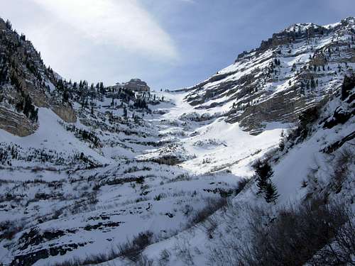
The canyon is large and surrounded by huge limestone cliffs on both sides. It is south of Mount Timpanogos, the most famous mountain in the Wasatch Range. The opposite side of the canyon rises steeply from the north face of Cascade Mountain. The majority of routes are located on the shaded south side of the canyon. During most of the winter season, the sun may not even touch the ice. The routes are mainly between WI4-WI5 in difficulty. Mixed climbing has become popular and several routes and variations are located in Provo Canyon.
Bridal Veil Falls was the first known ascent of a major ice route in the canyon. Greg Lowe climbed the falls solo in 1971. The route Stairway to Heaven was climbed in December of 1975 by Jim Knight and Mark Ward. It is one of the most climbed routes in the canyon along with Bridal Veil Falls. Jeff and Mike Lowe then climbed Stewart Falls located near Sundance and Aspen Grove on Mount Timpanogos. In Upper Provo Canyon, The Fang was climbed by Greg, Jeff, and Mike Lowe, Kim Miller, and Jim Knight. Then a nearby route known as Post Nasal Drip was climbed by Rick Wyatt and Evelyn Lees.
The first people to inhabit Provo Canyon were Native Americans. They included the Ute Indians who called themselves Timpanogotzis people. Obviously, this is where the name Timpanogos came from and the state of Utah was named after the Ute Indians. The first explorers came to Utah Valley in 1776. They were Spanish expedition leaders Francisco Atanasio Dominquez and Silvestre Velez de Escalante. Etienne Provost is thought to be the first white man to explore Provo Canyon which now bears his name. The road through Provo Canyon was finished in the summer of 1858 and then paved decades later.
I thought making a page for Provo Canyon would be helpful so that ice climbing information could be found easily. I don't live near Provo Canyon so I probably won't be able to keep up with current conditions. Feel free to add any of your route pages or photos.
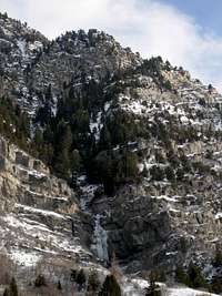
 Cascade Mountain north face location of most of the ice climbs - by marauders
Getting There
Provo Canyon Directions:
Drive on I-15 to (exit 272) which is 800 North in Orem. Turn here, and head east. Drive on 800 North through Orem towards the mouth of Provo Canyon. Stay in the left hand lane, which will drop onto Hwy 189. Continue into the canyon.
Parking Areas:
View Area Parking Area - Located before Nunn's Park Parking Area on the north side of the road. There is a nice pullout for several cars.
Nunn's Park / Bridal Veil Falls Parking Area - Approximately 4.7 miles up Provo Canyon. You’ll want to park on the south side to approach the ice climbs.
Upper Falls Parking Area - About 1.5 miles past Bridal Veil Falls Parking Area. Turn south and drive down the road for 0.5 miles to Upper Falls Parking Area.
Vivian Park Parking Area - Farther up Provo Canyon on the south side of the road. The South Fork Road branches off from Vivian Park.
North Side Parking - There are pullouts located on the north side of the road that are across from Lost Creek Canyon and areas to the east.
Aspen Grove Parking Area - Drive up Provo Canyon to Aspen Grove / Sundance (exit #92), which is the first left after the tunnel. Sundance is two miles up the canyon on the left. Aspen Grove is located farther along the main road with a well signed parking area.
 Pipe Dream Area - by builttospill
Lower Canyon
I refer to the routes located below and west of the Bridal Veil Falls Area as the Lower Canyon. There are two main parking areas. They are at the View Area Parking Area and Nunn’s Park. All of the routes are located near the bottom of steep gullies on the mountainside.
Getting There: The View Area parking area is located before Nunn’s Park parking area on the north side of the road. There is a nice pullout for several cars. You will have to cross the street to get to the ice climbs below Cascade Mountain. Nunn’s Park is also known as the Bridal Veil Falls parking area. It is located approximately 4.7 miles up Provo Canyon. You’ll want to park on the south side to approach the ice climbs. There is a good parking area here but it often fills up on the weekend.
Approach: From the Parking Area walk along the drainage on the south side of the road. You will be able to see the ice routes above you. Getting to the base of these climbs requires hiking up steep talus and snow. Most routes can be reached in about 10 to 20 minutes.
 Fudgepacker Fudgepacker |
 Hello Hello |
 Lower Canyon Routes Lower Canyon Routes |
 Pipe Dream / Litter Box Pipe Dream / Litter Box |
|---|
Pipe Dream: I, WI3-4, mixed - 180 feet
The Pipe Dream Area is also known as Kitty Litter Wall. This is the first major ice route located near the mouth of the canyon. It is near the junction with UT 52 and US 189 on the north side of the road. There is a service road where you can park and hike to the base of the route. It was named after the pipe which the route forms underneath. Pipe Dream is one of the first routes to dry out because it faces the sun.
Fudgepacker: I, WI5 - 90 feet
This is a single pitch climb that is located in the drainage west of the arched strata layers. These rock layers are easy to see from the bottom. The route forms on either side of a waterfall. Expect thin vertical climbing.
Fear of Motion: II, WI4 - 540 feet
This is a long route with up to 540 feet of climbing. It is located in the drainage that is east of the arched strata layers. These rock layers are easy to see from the bottom. The climb ascends bulges for over 300 feet and then splits into two gullies. The left fork is near vertical.
IceMate: I, WI4 - 50 feet --- PlayMate: I, WI4 - 60 feet
These two climbs are located in the same drainage about 200 yards east of Fear of Motion. IceMate is on the right side and is 50 feet in length. PlayMate is on the left side of the cliffband and is 60 feet in length.
Daily Fears: I, WI4 - 120 feet
This route is located south of Nunn’s Park and west of the route Hello. You can either climb that route or hike around to access Daily Fears.
Hello: I, WI4-5 - 80 feet
Single pitch climb located below Daily Fears. It has a short approach and climbs over 50 feet of vertical ice to lower angled ice.
 Stairway to Heaven - by marauders
Bridal Veil Falls Area
The Bridal Veil Falls Area is the center of ice climbing in Provo Canyon. Anyone driving down the canyon will notice the large amount of ice that is contained here. This is the most crowded ice climbing area in the canyon. Approaches are short and there are many quality climbing routes.
Getting There: The Bridal Veil Falls parking area is located approximately 4.7 miles up Provo Canyon. This is also known as Nunn's Park. There is a nice parking area for several cars. You can also park a little farther up Provo Canyon along the main road. There is a large pullout that is just north of Bridal Veil Falls. You can descend and hike directly to the ice climbs from here.
Approach: At Nunn's Park there is a trail that goes east that will be packed down in winter. The first route you will see is Stairway to Heaven. Farther down the trail you will get to the Bridal Veil Falls Area. The last route on the east side is All is Quiet. Once you are at The Bridal Veil Falls Area, you can hike up the talus field below the main routes. This area can be reached in 10 to 15 minutes.
 Stairway to Heaven Stairway to Heaven |
 Stairway to Heaven Stairway to Heaven |
 Stairway to Heaven Stairway to Heaven |
 Stairway to Heaven Stairway to Heaven |
 Stairway to Heaven Stairway to Heaven |
|---|
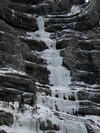
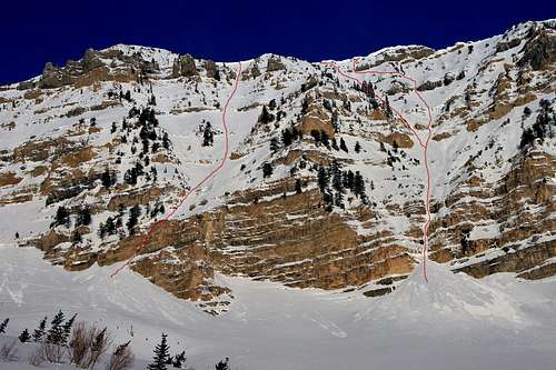
Stairway to Heaven: III, WI5 - 800+ feet
Stairway to Heaven is considered one of the best ice climbs in the canyon. There can be over 800 feet of ice climbing to the top of the route. The upper pitches do not always form. The first two pitches climb up to a wide ledge. Then the route ascends several pitches of vertical ice up a narrow curtain. Stairway to Heaven is popular and a few accidents have occured here. There are several variations on the left and right side that have been climbed. The most notable of these are Prophet on a Stick: WI6 or M7, located on the left of the 4th Pitch and Contrivance: M8 which is located left of the 5th Pitch.
 Bridal Veil Falls Bridal Veil Falls |
 Stairway to Heaven Stairway to Heaven |
 White Nightmare White Nightmare |
 Bridal Veils Falls Area Bridal Veils Falls Area |
 Stairway to Heaven Stairway to Heaven |
|---|
White Nightmare: I, WI4-5 - 200 feet
This route is accessed by the same approach as Bridal Veil Falls. Hike up to the amphitheater below the climb. This route is located to the right of Bridal Veil Falls and makes a nice alternative. It is usually climbed in two pitches but can also be done in one long pitch. The climbing is done on the face or in a series of curtains. Trees make good anchors at the top. Bring two 60 meter ropes to rappel the route.
Info from SP member jimk - I would suggest belaying underneath the curtain/overhang. Scramble up to a ledge and start from there, traversing left under the curtain. You'll be safer and have all the rope you need. White Nightmare got its name from spewage out of the large gully above and right. And that's not the big stuff. Monster slides from the upper basin follow the waterfall and obliterate everything. That's how the tram & base station got destroyed.
Four mixed routes located to the right of White Nightmare:
El Santa Blanca: M4-M5, This route is next to the right margin of White Nightmare. It’s easy to get to ice at any point. There are four bolts.
La Punta Blanca: M6-M8, This mixed route goes up the corner and angles left. It then climbs twenty feet of ice to reach the anchors on the wall above the rock roof next to the ice. This is a well bolted route. The difficulty depends on how much ice there is.
M-Possible: M7, Start on La Punta Blanca, then go straight up over a small roof. There are 8 bolts.
M-Possible Left: M6+, Start on La Punta Blanca, then go right up over a small roof. There are 7 Bolts.
 White Nightmare White Nightmare |
 Bridal Veil Falls Left Bridal Veil Falls Left |
 Bridal Veil Falls Left Bridal Veil Falls Left |
 La Punta Blanca La Punta Blanca |
 La Punta Blanca La Punta Blanca |
|---|
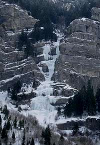
The Bridal Veil Falls Area has the most popular ice climbs in Provo Canyon. This area is a short approach from the parking area. The main falls has frozen in some years when the weather has been cold and there is a lot of snow. There will almost always be some running water. In most years, the waterfall will be flowing freely down the cliff while the right side of the falls will be frozen. The first ascent of Bridal Veil Falls was made by Greg Lowe.
Bridal Veil Falls Right: I, WI4-5 - 180 feet
This is the rightmost ice flow. It is located to the right of the Bridal Veil Falls Left route and to the left of White Nightmare. Bring a 60 meter rope to climb the route and have two to rappel off. Trees can be used at the top of the pitch as a anchor.
Bridal Veil Falls Left: I, WI4-5 - 180 feet
This route goes up the main flow of ice. It is to the right of the main falls and to the left of the Bridal Veil Falls Right route. It climbs over several bulges and a steep final pitch. Bring a 60 meter rope to climb the route and have two to rappel off. Trees can be used at the top of the pitch as a anchor.
Upper Bridal Veil Falls: II, WI5 - 180 feet
Upper Bridal Veil Falls is located above both lower falls. It can be climbed as a continuation of the lower routes. It has vertical ice climbing that can be done in one long pitch or two shorter pitches. Bring two ropes to rappel off the route or descend around the stairway to heaven drainage which is not recommended.
 Upper and Lower Bridal Veil Falls Upper and Lower Bridal Veil Falls |
 Bridal Veil Falls & White Nightmare Bridal Veil Falls & White Nightmare |
 All is Quiet All is Quiet | 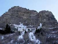 All is Quiet All is Quiet |
|---|
All Is Quiet: I, WI5 - 100 feet
This ice climb is located on the next large rock wall to the left of Bridal Veil Falls. All is Quiet is best approached from Nunn's Park. The name says it all and the route is usually not crowded. This cliff usually forms a large wall of ice with the left side being vertical. All is Quiet is located on the right side of the wall. The route goes over three tiers of steep climbing.
 The Fang - by Dow Williams
Upper Canyon
I refer to the routes located above and east of the Bridal Veil Falls Area as the Upper Canyon. The approaches start from the Upper Falls Parking Area. The routes are located in obvious gullies that have cut deep notches though the steep limestone cliffs.
There are also routes located in the vicinity of Vivian Park. They are not climbed as often so I will mention them here for now. The route Edge of Sanity: WI4 is located in Snow Slide Canyon. The route South Fork: WI3 is located along the South Fork Road.
Getting There: The Upper Falls parking area is located about 1.5 miles past Bridal Veil Falls parking area. Turn south and drive down the road for 0.5 miles to Upper Falls Parking Area. In winter, you can only drive to the gate where you can park on the side of the road. This is near the east side of the area where all of the ice climbs are located. Alternatively, you can park at the trailhead for Bridal Veil Falls, Nunn's Park, and walk to all of these routes from there.
Approach: From the parking area, the first ice climb you will be able to see is FMR Wall which will be directly south. Walk toward the base of the cliffs and start hiking west. The Fang will be a short distance west of FMR Wall. Farther west are the routes Post Nasal Drip and Finger of Fate. There is a long snow couloir that is located west of Finger of Fate. The routes in this area can be reached in 10 to 20 minutes.
 FMR Wall FMR Wall |
 The Fang The Fang |
 The Fang The Fang |
 Upper Canyon Ice Climbs Upper Canyon Ice Climbs |
|---|
FMR Wall: I, WI4 - 180 feet
The route is located in the next drainage east of The Fang. It is the first ice route you will see that is immediately south of the Upper Falls parking area. You can either get there by climbing directly up the drainage or traversing east from the top of the Fang to the base of the climb. The route goes up a 180 foot wide wall of ice and is usually done in two pitches.
The Fang: II, WI5 - 400 feet
The Fang is located on the east side of this cliff band. Pitch 1 and 2 climb straight up the ice flow. Then the route ascends a WI3 snow gully. The final pitch goes up “The Tube” which is considered one of the highlights of the route. Climb up a narrow 50 foot column.
 The Fang The Fang |
 Miller's Thriller Miller's Thriller |
 Finger of Fate Finger of Fate |
 Upper Canyon Ice Climbs Upper Canyon Ice Climbs |
|---|
Miller's Thriller: II, WI3-4 - 400 feet
Miller's Thriller is just east of Post Nasal Drip. The first pitch goes up a lower angled WI3 gully to the bottom of the second pitch. It then ascends this snow slope to the beginning of the crux pitch. There is a more difficult variation known as Miller's Pillar: WI5-6 that climbs over an overhang to the left of the third pitch.
Post Nasal Drip: II, WI5 - 400 feet
This route is located between Miller’s Thriller and Finger of Fate. Post Nasal Drip is 4 pitches long. Hike up the gully and then climb the first pitch and second pitch up a column. The third pitch is 80 feet and then ascends over two bulges on the last pitch. When conditions are thin and the route is not a continuous ice climb it is known as Snotty Nosed Brat and is rated M6 with aid climbing.
Finger of Fate: II, WI4 - 500 feet
Finger of Fate is the westernmost ice route that is east of the Bridal Veil Falls Area. The route is usually done in 4 pitches. The first pitch climbs a 130 foot corner. The remaining three pitches continue up several tiered steps on the route. There is another snow couloir that is located west of Finger of Fate but it doesn’t seem to have any significant ice in it.
 Lost Creek Canyon
North Side
The north side of Provo Canyon sits near the lower slopes of Mount Timpanogos. It receives a lot of sunshine and has less ice routes than the cold and shaded south side. The good news is that the area is nice and quiet.
Getting There: The north side of Provo Canyon is climbed much less that the south side and parking is always available. There are pullouts located on the north side of the road that are across from Lost Creek Canyon and areas to the east. Most routes can be seen above the road.
Approach: Lost Creek Canyon is easily identified as the canyon immediately north of the Bridal Veil Falls area. From your parking area, walk north toward the cliff bands on the east side of the canyon. There is no trail but route finding through the sagebrush and boulders is easy. There are three routes located east of Lost Creek Canyon. They include Avalanche Falls, Soft and Juicy, and Shower Tower. They are on the cliffband nearby and can be seen from the road. The hike to the base of these climbs is short and steep. All of these routes face the sun. Approach time is 15 to 30 minutes.
 Provo Canyon North Side Provo Canyon North Side |
 Lost Creek Canyon Lost Creek Canyon |
 Soft and Juicy Soft and Juicy |
 Shower Tower Shower Tower |
|---|
Lost Creek Canyon: I, WI4-5 - 50-100 feet
Lost Creek Canyon is the large canyon below the south side of Mount Timpanogos. It can be seen from the highway and has several short ice climbs near the eastern side of the canyon. These routes are single pitch climbs.
Avalanche Falls: I, WI4 - 100 feet
This route is located 1,500 feet east of Lost Creek Canyon in a smaller canyon. You’ll be able to see it from the road where you can park near one of the pullouts. This route is nearby to the west of Soft and Juicy. A single pitch route goes up a 35 foot curtain, a snow slope, and then a last 20 foot curtain.
Soft and Juicy: II, WI5 - 300 feet
The same approach is used as for Avalanche Falls. This ice climb can usually been seen hanging on the steep cliffs above the road. It can be climbed in 2 pitches. The first pitch goes up some small pillars and then the second pitch climbs over a 60 foot pillar and a few shorter ones to the top of the route.
Shower Tower: I, WI5 - 150 feet
Shower Tower is located in the next notch east of Soft and Juicy. This is about 400 feet away. This route has a double pillar with a small ledge in between. The middle part of the route is usually dry leaving a narrow pillar of ice on the top and bottom.
 Primrose Cirque above Aspen Grove and the approach to Roberts Horn
Aspen Grove
Aspen Grove is a beautiful area and only accessible from Provo Canyon during winter. The Alpine Loop Road from American Fork is closed but is a favorite place for cross country skiers. Aspen Grove is where the most hiked trail for Mount Timpanogos starts. Sundance Ski Resort is located below Aspen Grove.
Getting There: Drive up Provo Canyon to Aspen Grove / Sundance (exit #92), which is the first left after the tunnel. Sundance is two miles up the canyon on the left. Aspen Grove is located farther along the main road and has a well signed parking area. There is a $3.00 parking fee at the trailhead that is good for three days.
Approach: The trail up Primrose Cirque starts north of the parking area. Hikers may pack down the trail in winter. Expect to do some trail breaking after a recent snow storm. A junction will be a short distance down the trail. The route to Stewart Falls, aka Stewart Cascades, goes left or south and the other route toward Primrose Cirque and Mount Timpanogos goes north. The trail to Stewart Falls will take about 30 minutes to an hour to get to the base of the waterfall.
The other trail goes toward Mount Timpanogos and contains all of the other ice climbs in the area. Hike on this trail toward the Aspen Grove Falls. Many people stop at the falls and turn around. So this is where the trail breaking begins for most people. The route follows the side of Primrose Cirque below the east face of Roberts Horn. Approach time is about an hour to Aspen Grove Falls and about 2 to 3 hours for the higher routes above Primrose Cirque.
 Stewart Falls Stewart Falls |
 Stewart Falls Stewart Falls |
 Aspen Grove Falls Aspen Grove Falls |
 Roberts Horn Roberts Horn | 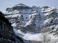 Roberts Horn East Face Roberts Horn East Face |
|---|
Stewart Falls: II, WI5 - 220 feet
Stewart Falls is a nice hike in the summer but is even more beautiful in winter. The falls is below Big Provo and Cascade Cirque on Mount Timpanogos. The shortest route is from the Sundance Ski Area but most people hike to it from the Aspen Grove trailhead. It is a two pitch vertical ice climb. Many people belay from the large alcove in the middle of the falls. The steep hanging icicle located on the wall to the right of Stewart Falls is rated WI5-6.
Aspen Grove Falls: II, WI4-5 - 50-100 feet
Hundreds of people hike past these waterfalls every year but fewer see them in winter. There are several falls in the area known as Primrose Cirque that make nice short ice climbs. The trail travels right below the steep east face of Roberts Horn and is subject to avalanches so caution is advised.
Picture Window: II, WI3 - 60 feet --- Skylight: II, WI4 - 40 feet
These two routes are reached from the Aspen Grove Trail. They are located past Timpanogos Couloir above the switchbacks. It is a 3.5 mile hike to the base of these routes at 9,000 feet. Picture Window is the larger lower falls while Skylight is the narrow more difficult ice route located above Picture Window.
Timpanogos Couloir: II, WI3-4 - 600-700 feet
This is one of the longest routes in the area. The Aspen Grove trail is used to access Timpanogos Couloir. The approach goes past the Aspen Grove Falls and climbs up the final switchback on the trail to the cirque above Aspen Grove. The Couloir is located on the right side of the cliffband high above the cirque. This is where the trail passes a steep canyon that faces toward the south. The route is best done in spring or late fall. In winter, it is mostly a long snow climb.
Roberts Horn East Face: II, WI4-5 - 300-500 feet
Roberts Horn is an non-technical hike in summer. It's more difficult to get to in winter. There a many snow and ice couloirs located on the east face of Roberts Horn. The routes are 3 to 5 pitches in length over steep and icy rock slabs. Expect protection to be difficult on some of these pitches. Avalanche danger is very high and ice climbing should only be done when the snow is stable.
 Roberts Horn East Face Routes - by marauders
Utah Ice Climbing History
 Malans Waterfall
 White Nightmare
This is a brief history. Ice Climbing in the Wasatch Mountains began as early as the 1960s. The interest in ice climbing was led by the Lowe family. So how many Lowes are there? They include brothers Jeff, Greg, and Mike, cousin George, and his brother Dave. They were from Ogden, Utah near the Northern Wasatch Mountains. They were instrumental in the development of ice climbing in the United States.
The Lowes started climbing in the rugged cliffs above their house when they were kids. Years later, they began climbing the steep waterfalls and snow couloirs. Alex Lowe was not related to the other Lowes mentioned earlier. He lived in Utah for several years and climbed many difficult routes. He was considered one of the greatest climbers of his generation. Sadly, Alex died in an avalanche on Shishapangma in Tibet.
Several lower angled ice couloirs and gullies were being climbed in the Wasatch Mountains. Climbers then started to try more difficult routes. One of the first major ice routes to be climbed was the Great White Icicle: WI3 in Little Cottonwood Canyon. It was climbed in the 1960s by Rick Reese and Ted Wilson. They used a step cutting technique to climb the route.
The Lowe brothers thought that climbing Malans Waterfall: WI5 in the Northern Wasatch would be good training for climbing other areas in winter. The waterfall was located a short distance from where they lived. They were able to practice using their new equipment and techniques everyday. Greg Lowe made a solo ascent of Malans Waterfall in 1971. This was the first vertical waterfall to be ice climbed in Utah.
Bridal Veil Falls was the first known ascent of a major ice route in Provo Canyon. Greg Lowe climbed the falls solo in 1971. The route Stairway to Heaven was climbed in December of 1975 by Jim Knight and Mark Ward. Many people consider this to be the best quality ice climb in Utah. Jeff and Mike Lowe then climbed Stewart Falls located near Sundance and Aspen Grove on Mount Timpanogos. In Upper Provo Canyon, The Fang was climbed by Greg, Jeff, and Mike Lowe, Kim Miller, and Jim Knight. Then a nearby route known as Post Nasal Drip was first climbed by Rick Wyatt and Evelyn Lees.
Santaquin Canyon became the next great place to ice climb. It is a good alternative to Provo Canyon. It is located about 20 miles south of the city of Provo. It has a large amount of ice climbs that range from moderate to difficult. In more recent years, mixed climbing has become popular here. Ice climbing began in Santaquin Canyon in the 1970’s. Doug Hansen and his friends climbed the routes Squash Head and Backoff. In the early 1980s, the routes Candlestick and Automatic Control Theory were climbed. Then more difficult mixed routes were put up by several climbers in the 1990s.
Interest then led to other places including Maple Canyon and Joes Valley which also offer good ice climbing. Maple Canyon is located west of the city of Manti. It is in the San Pitch Mountains south of the Wasatch Mountains. It is known for its cobble rock climbing but during winter it becomes an icy playground. There are many routes but some of them may require lengthy approaches. Besides ice climbing, Joes Valley is known for its bouldering. Mixed climbing can also be found in these areas.
 Stairway to Heaven - by marauders
When to Climb
 East Provo Canyon
 Provo Canyon
The best time to climb in Provo Canyon is from early December through mid-March. Conditions vary each year but you can usually count having at least three months of ice climbing. Saturday is the most crowded day of the week for ice climbing. Sunday mornings are much nicer because many people will be at church. Weekdays are usually more quiet.
Routes that don't see sunlight may be in good shape well into spring. The higher routes above Aspen Grove are best climbed in late fall or early winter before considerable snow has accumulated. These routes can also be climbed all winter with a more strenuous approach.
The road through Provo Canyon may be closed in winter due to snow. This usually only last a day or two in order to allow the road to be plowed. A 4-wheel drive vehicle and chains are recommended in the worst conditions. Check road status at the UDOT website.
Provo Weather Forecast and the NWS Forecast.
Red Tape
 Stairway to Heaven
 Bridal Veil Falls
There are no fees for climbing in Provo Canyon.
There is a $3.00 parking fee at Aspen Grove Trailhead.
Avalanche Danger: The majority of routes are located on the steep north face of Cascade Mountain. These ice climbs are actually located near the bottom of avalanche gullies. There are avalanches every year that come crashing down the mountain so check conditions before you go at the Utah Avalanche Center website.
Please Note: There have been fatalities from ice climbers falling in Provo Canyon. If conditions are not good or seem hazardous it's a good idea to wait another day.
Books
Ice Climbing Utah
By David Black. This book has information on many of the ice climbing areas in Utah. It describes areas of the Wasatch Mountains including Provo Canyon, nearby Santaquin Canyon, and the Cottonwood Canyons.
External Links
Utah Avalanche Center
This website has information in the Wasatch Mountains on current conditions, advisories, accidents, and weather.
Sundance Ski Resort
Sundance Ski Resort is only a few miles farther up the canyon just before the turnoff to Aspen Grove.