
-
 7700 Hits
-
 82.33% Score
-
 15 Votes
|
|
Mountain/Rock |
|---|---|
|
|
43.13797°N / 116.81593°W |
|
|
Owyhee |
|
|
Hiking, Scrambling |
|
|
Spring, Summer, Fall |
|
|
6336 ft / 1931 m |
|
|
Overview


Trails / Routes
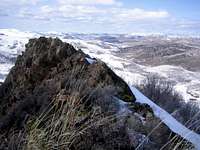
- North Approach- The north side approach starts at China Flat or just west of that point at a prominent division in the road. The approach Jeep Road parallels a significant rocky ridge that runs north-south and crosses Succor Creek just before leaving the Jeep Road for the scrambling. A variety of interesting alternatives around the summit ridgedefines the difficulty level from Class 2 to Class 4. 1200 feet of gain in 4.75 miles (one way)
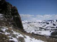
- East Side Slopes- This approach starts at the upper reaches of Reynolds Creek near Johnston Draw. Follow the Johnston Draw west contouring north and cross Succor Creek just southeast of Rooster Comb Peak. Choose an interesting line up one of the south side gulleys. 1770 feet of gain in 2.9 miles (one way)
Numerous other possibilities exist and allowing extra time to explore the hundreds of rock outcroppings in the area is always a possibility.
Maps: USGS Rooster Comb Quad, USGS De Lemar Quad
Getting There

Just south of the prominent ID-45 / ID-78 junction, take the signed Reynolds Creek Road. Follow this improved (paved for a portion) road for 14.3 miles until you reach the small town of Reynolds. About 0.3 miles south of the cemetery, turn right (west) and follow this dirt road 4.7 miles and park at the prominent clearing and road junction. The road winds it's way up the slope and is subject to snowy and muddy conditions.
Conditions and Season
National Weather Service-Boise


Even though the Owyhee Range (also called the Silver City Mountains), sits south of Boise and has many desert like features, the area receives a good amount of snowfall and nearly twice the annual precipitation as nearby Boise.
| Silver City, Idaho (Elevation 6150) Climate Data: | Jan | Feb | Mar | Apr | May | Jun | Jul | Aug | Sep | Oct | Nov | Dec | Annual |
| Average Max. Temperature (F) | 35.9 | 38.1 | 45.0 | 51.9 | 60.8 | 69.9 | 80.7 | 80.2 | 70.6 | 58.1 | 41.8 | 35.7 | 55.7 |
| Average Min. Temperature (F) | 20.4 | 20.9 | 27.0 | 31.6 | 40.3 | 46.6 | 55.5 | 55.0 | 46.2 | 36.8 | 25.1 | 20.5 | 35.5 |
| Average Total Precipitation (in.) | 2.91 | 2.16 | 2.29 | 2.40 | 2.49 | 1.34 | 0.60 | 0.54 | 0.82 | 1.41 | 2.10 | 2.09 | 21.15 |
| Average Total SnowFall (in.) | 20.3 | 13.0 | 10.6 | 5.7 | 2.0 | 0.1 | 0.0 | 0.0 | 0.2 | 2.0 | 11.0 | 15.5 | 80.5 |
| Average Snow Depth (in.) | 22 | 27 | 19 | 5 | 0 | 0 | 0 | 0 | 0 | 0 | 3 | 12 | 7 |