
-
 36384 Hits
-
 87.8% Score
-
 28 Votes
|
|
Mountain/Rock |
|---|---|
|
|
43.00708°N / 116.70459°W |
|
|
Owyhee |
|
|
Hiking |
|
|
Spring, Summer, Fall |
|
|
8051 ft / 2454 m |
|
|
Overview
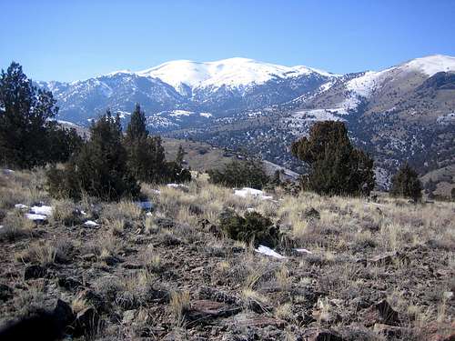
War Eagle Mountain sits above the historic mining town of Silver City. In the1860's silver was discovered on the mountain and the area has never been the
same since. Like many of the boom and bust towns, Silver City sprung up
very quickly. At the time, War Eagle Mountain mines had richer ores and larger
initial production than any other mining area in the world. The area
produced over 60 million dollars worth of ore and boasted a population of 2500
residents. Today, Silver City and the War Eagle Mountain area is home to a
few summer time residents, and usually none in the winter.

The Owyhee region of southwestern Idaho was one of the last areas settled in the lower 48 states. It is named after Hawaiian explorers that entered the region and were never seen again. Owyhee County is Idaho's second largest county and is twice the size of Connecticut with 4.9 million acres and only 1.3 persons per square mile and 10,000 residents total. The elevations start at 2,000 feet in the canyons and rise to more than 8,000 feet in the Owyhee Mountains. Eighty-four percent of that acreage is federally owned, and the majority of that land is managed by the BLM. Pretty much anything goes in the region in regards to land use. Motorized vehicles go anywhere and poaching is common. There is no regard for
conservation or federal management and regulation (A common Idaho legislative practice). There's a great potential for the explorer and hiker if they can deal with this.

War Eagle Mountain is riddled with old mining entrances and equipment
remnants. Some interesting relics and collectibles can still be found.
There are hundreds of marked mining related items on the USGS quad. More
recently, radio towers were placed at the summit, adding to the influence of man
on this beautiful peak. Just south of War Eagle Mountain is Hayden Peak, the
range's tallest at 8403 ft.
Trails / Routes
- Linehan Flat Road- Most common access. Leave the Silver City Stage Road half way between New York Summit and the ghost town of Ruby. This area was the site of many stage coach robberies in the 1800's. Follow the Jeep road south through a forest until it opens up just east of the peak. Leave the Jeep road and hike due west onto the summit. The condition of this road varies from year to year and is prone to wash-outs and deep, lingering snow. 2000 feet of gain in 3.5 miles
- West Slopes- Access these from the Silver City area- open ended route with many different possibilities, of which one includes a walk by the historic cemetery from the 1800's.2400 feet of gain in 2.75 miles
Getting There
The Silver City Stage Road from ID-78 is closed due to heavy snow each winter.In late 2005, the road was completely washed out during a heavy rainfall.
The area can be approached from Jordan Valley and the Oregon side also.
ID-78 runs along the northern edge of the Owyhees and can be accessed from
Nampa or Mountain Home, Idaho. Just south of Murphy on ID-78, follow a well
signed dirt road that leads from desert and canyon to sub-alpine Juniper.
This road can be crowded on summer weekends and the area in general receives tons of off-road vehicles. It is 18 long, winding miles from ID-78 to
Silver City.
Condition and Seasons
cams, web sites, or backcountry road information. If your from out of area,
these are the closest resources:
National Weather Service-Boise
Even though the Owyhee Range (also called the Silver City Mountains), sits
south of Boise and has many desert like features, the area receives a good
amount of snowfall and nearly twice the annual precipitation as nearby Boise.
The Newspaper in Silver City was named the Owyhee Avalanche. A look in
the pioneer cemetery reveals that many gravestones say the deceased were buried in snow. Use caution when approaching the open slopes of the mountains in this area during the winter.
History

deaths. Along with the documented Stage Coach robberies and murders in the
region, there was at least one major uprising amongst miners against management in the late 1800's. The workers were fed up with conditions and payment terms and shot and killed several supervisors. During the Bannock Indian uprising, the U.S. Calvary was called down from Boise and slaughtered a portion of a group of natives near South Mountain. The Indians had also ambushed and killed settlers and travelers along the nearby roads.
The Swan Falls Dam on the Snake River was built exclusively to generate power for Silver City. The dam still remains and is a short drive from Boise,ID. Summertime visitors to Silver City will notice that the electricity in the historic buildings is all 12 volt based and dim. This makes for an appropriate atmosphere if you stay overnight in the old hotel.
Silver City remains one of the best living ghost towns to visit in the U.S.- isolated, rugged, and no commercialization.
Silver City Photos and History
Ghost Town Information on Silver City
Silver City History, Pictures and Family Information
Geology
[img:172865:aligncenter:medium:]The Owyhee uplands are part of the Basin and Range region. The mountain range runs north to southeast separated by broad basins. Geologically the Owyhees extend southeast into Nevada and the Ruby Mountain region.The lower slopes of War Eagle Mountain contain some of the most impressive
rock outcroppings in all of southwestern Idaho. The rock is mostly granite with a patina covering. Agates, Petrified Wood, Garnets, and Crystals are commonly found in the canyon portion of the region.