
|
|
Mountain/Rock |
|---|---|
|
|
39.29355°N / 119.95782°W |
|
|
Washoe |
|
|
Hiking |
|
|
Summer, Fall |
|
|
9710 ft / 2960 m |
|
|
Overview
Rose Knob Peak is located on the southwest ridge of the Mount Rose Wilderness, a ridge that extends all the way to Lake Tahoe near Kings Beach. Rose Knob Peak is an easily accessible summit reached from off the Tahoe Rim Trail during summer months. It is distinctive given its rocky top, and is seen by thousands of people every day who make the drive over the Mount Rose Highway from Reno to Lake Tahoe; many of whom may point out "what is that amazing mountain up there?" Rose Knob Peak can be hiked any number of ways.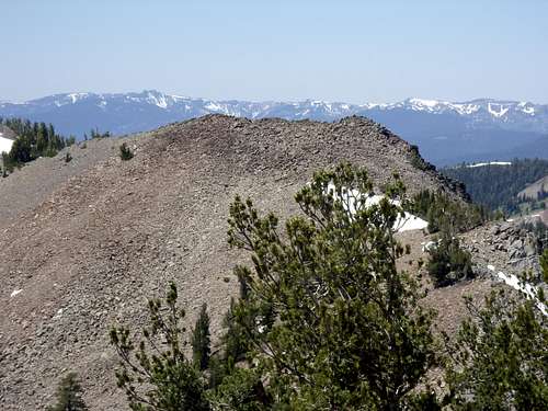
Rose Knob Peak from Peak 9773
Getting there from the nearest Tahoe Rim Trail parking area at the Relay Peak Service Road is quite long (Over 7 miles one way to get to Rose Knob Peak). However, a trail from Incline Lake Road leads to the Tahoe Rim Trail in 1 3/4 miles, and reaches Rose Knob Peak in less than 3 miles. Rose Knob Peak can also be approached from Incline Village via a steeper trail.
Views of Lake Tahoe are spectacular from this trail, and especially from Rose Knob Peak. There are also excellent opportunities for rock climbing and scrambling. Once atop the Tahoe Rim Trail, you can also hit nearby Peak 9773 just across from Rose Knob Peak and Rose Knob 9,610' about 1 ¼ miles west of Rose Knob Peak. Incline Peak 9,561' is also an easy hike from the ridge. It only adds a couple hundred feet and 2/3rds of a mile round trip.
The best time to hike here is probably July through October when the Tahoe Rim Trail is free of snow. Any earlier in the season and there is greater risk of losing the trail and then getting lost in the woods. It has happened to me twice - both times on the descent. You need to be very aware of where you are going, as there are trails in multiple directions in the vicinity of Incline Lake, that can easily cause confusion.
Getting There
From Reno take Highway 395 to the Mount Rose Highway (431). The Mount Rose Highway runs for about 20 miles between Reno and Incline Village. Take 431 as it winds up the mountains. At the top of the road is the Mount Rose Summit at 8911’. Go past it. There are at least a couple good spots to start the hike, but two primary areas off of Mount Rose Highway.The most straightforward way is to head about 1 1/2 miles past Mount Rose Summit to the edge of the Tahoe Meadows. On the right side of the road is a dirt road and parking area. This is Incline Lake Road. A gate blocks automobile access. Park anywhere around here.
If you want a little longer trail all the way up, head about 3 miles past Mount Rose Summit going towards Incline Village. Pass the phone booth on the right hand side of the road, and look for a dirt road on the right, about a mile past it. Head down the road, which terminates after a couple hundred yards. Park here, and look for the trail below. It is unmarked, but is right by the end of the road on the right hand side. The greatest challenge is finding the trail, but it goes right up the woods along the north side of a creek.
Finally, to reach the Incline Village approach, head further down 431 past Country Club Road and head north on Marlette Way which quickly turns into Jennifer Street and reaches the trailhead in two-thirds of a mile.
Route Information
Route #1 – Incline Lake RoadJust across from the edge of Tahoe Meadows is Incline Lake Road. It is a fire road closed to motor vehicles, so you must park at the beginning of the road at about 8575’. Follow the road as it descends for about 1/2 mile. When the road loops around there is a cairn marking a trail. Take the trail which descends and connects to a trail heading north towards the peaks. The trail is confusing at times, especially when there is snow. You run into the connector trail described in route #2. Continue north up the trail as it heads around the north side of Incline Peak. After about a mile up the trail you should reach the ridge at about 9365’. The spires below Peak 9773 are just above you. Rose Knob Peak is further to the left.
Follow the trail down slightly, and it soon connects with another trail. This is the Tahoe Rim Trail. Head left to reach Rose Knob Peak. The actual distance to the summit depends on how you go. Once you pass above Mud Lake on the trail and get to the base of Rose Knob Peak, a trail basically leads almost all the way to the summit, first taking the Tahoe Rim Trail, and then an off-shoot approaching from the south. This is 3 miles one way. But that can easily be cut down to just over 2 1/2 miles away if you scramble from the trail junction to Gray Lake. This approach is the northeast side and climbs up nearly 300' in less than a quarter of a mile. The total elevation gain is about 1,350'.
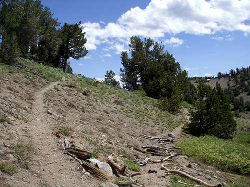
The connector trail meets the Tahoe Rim Trail

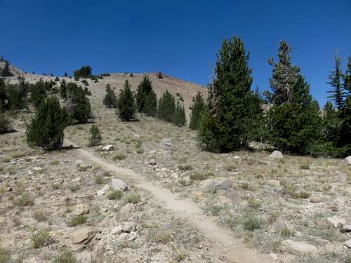
The final stretch to Rose Knob Peak from the northeast
The final stretch to Rose Knob Peak from the south
Route #2 – Connector Trail
This route starts off a dirt road 3 miles past Mount Rose Summit heading towards Incline Village. Finding the trail is the most difficult thing to do. It actually goes right up to the road, but isn’t perfectly obvious. Use your best judgment. It crosses a creek with a big piece of flat wood, and then skirts the base of Incline Peak. The dirt road is at about 8200’. The trail will climb up through the forest to the main ridge between Peak 9773 and Incline Peak in about 2 miles, gaining about 1265 feet in the process. Once at the ridge, you will see the spires below Peak 9773. Follow the same route described above to Rose Knob Peak.
The one way distance to Rose Knob Peak is about 3 to 3 1/4 miles and about 1500 feet.
Route #3 - Jennifer Street - Incline Village
From the trailhead at about 7,438’ take the trail steeply up over 2,000 feet, in less than 2 miles to the Tahoe Rim Trail. The total elevation gain to Rose Knob Peak is about 2,300 feet and one way distance of just over 2 miles. If adding Peak 9773, it is about 5 miles round trip, with an elevation gain closer to 2,750'.