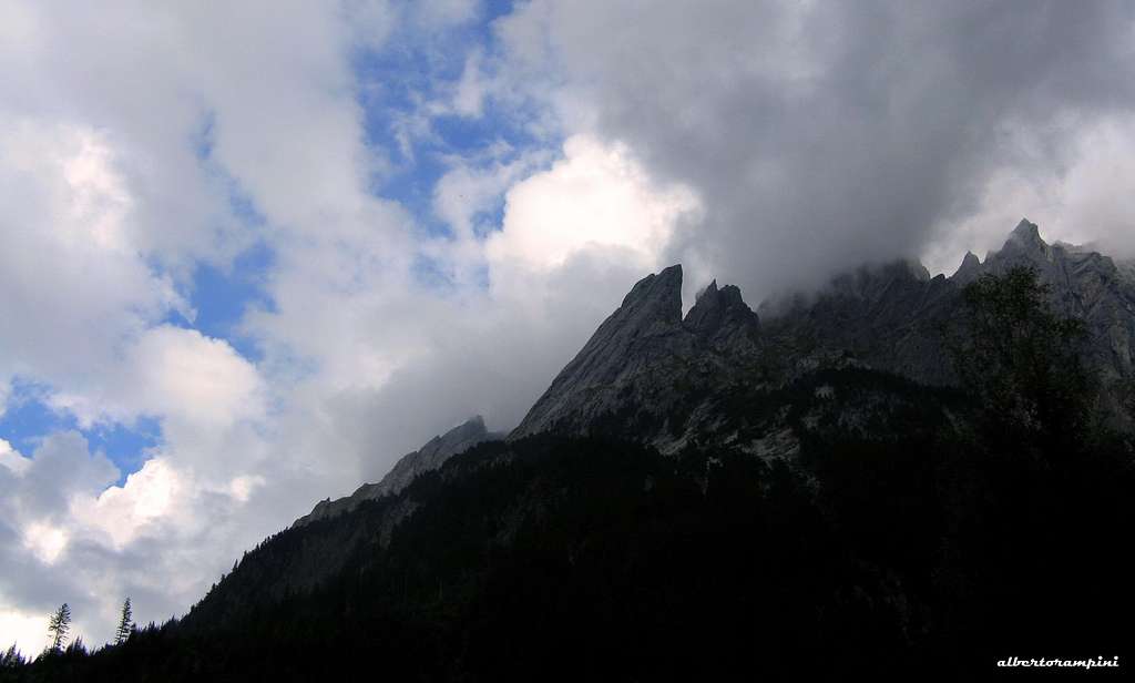
The Engelhörnergroup is an extensive limestone range about 4 km. long, located in the Berner Alps, near Meiringen. Belonging to the Engelhörner West Sector, including the highest Tannenspitze, Engelburg and Sattelspitzen, Rosenlauistock 2198 m is a fine slender pinnacle. Unlike most of the mountain ranges of this area of the Swiss Alps, which are mainly in granite, the Engelhörner chain shows peaks and walls made of compact limestone, a real paradise for the climber.
Wetterhorn early in the morningEngelhörner, a forest of bizarre needles
The particular stratification of the Cretaceous limestone that forms the Engelhörner chain gives to the summits a peculiar appearance, sometimes with a bit bizarre shapes. Rosenlauistock counts different classic routes of moderate difficulty on West Face and even some modern climb on excellent rock on SW face.
Rosenlauistock seen from Rosenlaui
Getting There
The nearest town to the Engelhörnergroup is Meiringen near the Brienzersee.
Alps and pastures along the road to Rosenlaui
There are two possible approaches to Rosenlauistock, depending if you want to stay overnight at the "Engelhorn-Hutte" hut, or not. From Meiringen follow the beautiful road to Rosenlaui (Schwarzwaldalp road). Getting to a fork (loc. Gschwantenmad) in the upper part of the road you can choose between the two different approaches:
- on the left side it starts a toll road (Zwirgi Schwarzwald road) that ends at the mountain farm Rychenbachalp (where you must pay CHF 15), allowing a shorter access to the "Engelhorn-Hutte" (about 1 hour by walk from to the farm).
Start from Rychenbachalp, RosenlauistockThe trail to Engelhörner Hut from Rychenbachalp
- the main road to Rosenlaui is instead the best solution for those who have decided to climb in 1 day without stay overnight at the "Engelhorn-Hutte". Following the main road to Rosenlaui you will reach the large parking lot above the Rosenlauihotels (on the road to Schwarzwaldalp) from where the approach to the shelter is longer (about 1 hour and 40), but from where you can approach directly the Rosenlauistock in 1 hour
Route
Haslizwerg report - French scale
Summit altitude: 2198 m Difficulty: TD, max 6a+ (French scale) Equipment: belays equipped with cemented anchors, pegs along the pitches Climbing length: 270 m Exposure: SW Starting point: Rychenbachalp or Rosenlaui
Fine moderne route full equipped on excellent limestone. The setting is wonderful!
Engelhörner wonderland
Approach from Rosenlaui 1360 m From the car park above the hotel Rosenlaui take the path to the Engelhörner Hutte (common beginning with that one to Dossen Hütte). After a short steep climb, the trail runs horizontally to the left through an area of smooth slabs; at one point a trail marked by two large cairns heads straight up towards the base of the tower in the direction of the descent gully. Reached the lower exit of the gully, traverse to the left along a trail skirting the walls in te direction of the SW wall. The route Haslizwerg starts a few meters above the highest point of the trail, near a vague pillar, on the left of the descent gully and on the right of a great overhang.
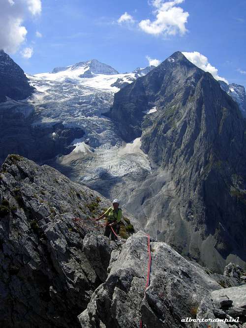
Rosenlauistock summit view towards Wetterhorn
Approach from Rychenbachalp From the farm take the path rising to the Engelhörner Hutte, at first running inside the forest, then exiting and traversing along a steep grassy slope, getting to the nice refuge located just under the Kingwande (1 hour from the farm). Go through the refuge and beging to skirt the walls, getting to the North West slabs of Rosenlaui, where there are located the less demanding climbs. The path reaches the junction with the one coming from Rosenlaui. Take the left trail, climb some easy rocks and continue along the trail, sometimes uncertain, continuing to traverse along steep slopes and reaching the lower of Rosenlaui descent rocky gully, useful reference point to find the start of the route not really obvious. Reached the outlet of the gully traverse to the left along a trail towards the base of the SW wall. The route starts a few meters above the highest trail point of the trail,, near a vague pillar, on the left of the descent gully and on the right of a great overhang. Route report
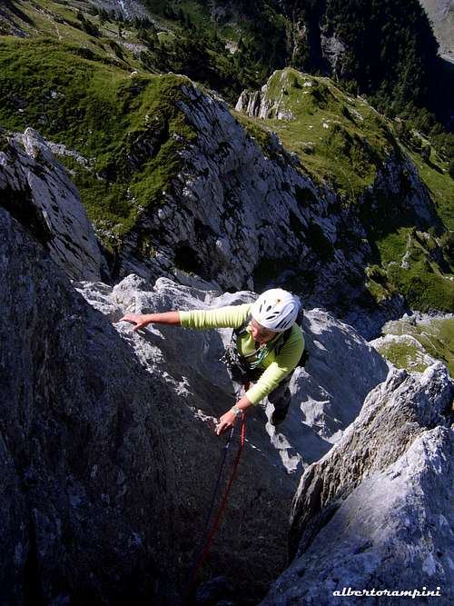
L1 - Slanting left along a slab to a small overhang beyond which slanting right on a slab, then a vertical edge and a short crack, 6a+ L2 - Overcoming a couple of walls, reach the grassy terrace. Stop at the edge of the large grassy slope, 5b L3 - Easy transfer pitch on the grassy slope towards left to reach a stance the base of an overhanging pillar (visible slings inside some holes)
Start of the route HaslizwergAn excellent compact limestone on Haslizwerg
L4 - Climb the pillar on a a smooth vertical slab, reaching a wonderful overhanging wall with excellent holds, then a small crack leading to the stance, 6a L5 - On easier terrain climb a ridge, then with a delicate traverse to the right reach the base of a steep dihedral, 5c +
Superb limestone on Haslizwerg>
Belay near the summit
View from Rosenlauistock
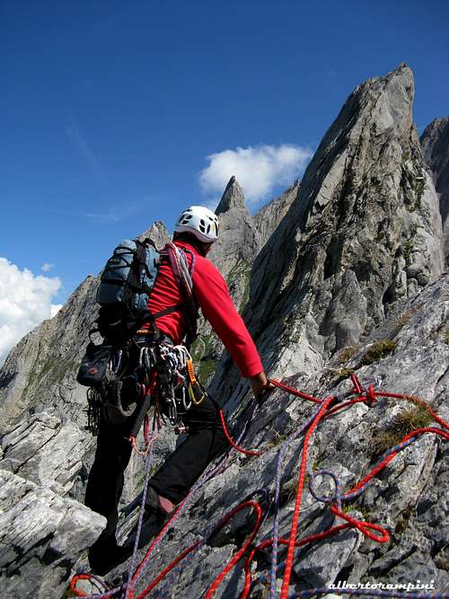
L6 - Hard move on an overhanging wall just above the stance, then climb the magnificent dihedral to the next belay, 6a + (or A0). L7 - On a less demanding terrain reach a very smooth slab L8 - Overcoming the smooth slab up to a stance with route book L9 - An easy pitch to Rosenlauistock West foresummit (belay on an outcrop) L10 - From the foresummit after a slight descent, skirt the summit crest between the foresummit and the summit to a notch (peg), from where an easy climb leads to the summit
Rosenlauistock descent ledgeSummit of Rosenlauistock
Descent - From the summit downclimb easily towards SE, follow a ledge below to the pass from Rosenlauistock and Tannenspitze. Descent along the rock gully (1 abseil) to reach the bottom of the gully and the foot of the route. From there you can reach the Engelhorn hut in 20 minutes
Other routes
- Nord West Flanke 4c, 220m, 12 pitches 2-3a, 2b, 3a, 3b, 4a, 4b, 4a, 3c, 2b, 3b, scramble to top. It climbs a slab right of the overlaps, finally reaching the right ridge to finish.
Summit of RosenlauistockSummit box on Rosenlauistock
- Grosse Nordvershneidung TD 400m, 12 pitches
- West Ridge (Westkante) 4c 9 pitches 2b, 4b (2 p.a. (5c)), 2c, 3c, 4a, 3c, 3c, scramble to the summit
No particular restrictions in climbing and hiking. The road to Rychenbachalp involves the payment of a toll (CHF 15).
When to Climb
Best season is summer
Hut
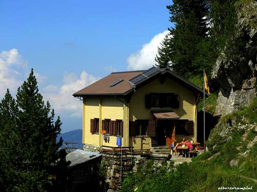
Engelhörner Hut
Engelhorner hütte 1910 m, 50 places. Info Phone/Fax: ++41 (0)33 971 35 37 Meiringen
The Engelhornhütte lies at the northeastern end of the Ochsental above the Reichenbachtal.
The first Engelhorn hut was built in the Ochsental in the year 1912 by the Academic Alpine Club Berne, since this lonesome and creekless valley is the starting point for the majority of the climbs. An avalanche destroyed this hut and the present accomodation is surrounded by trees at the foot of the Simelistock, 15 minutes below the Ochsen Valley.
Children refers to the set of objects that logically fall under a given object. For example, the
Aconcagua mountain page is a child of the 'Aconcagua Group' and the 'Seven Summits.' The
Aconcagua mountain itself has many routes, photos, and trip reports as children.
Parents refers to a larger category under which an object falls. For example, theAconcagua mountain page has the 'Aconcagua Group' and the 'Seven Summits' asparents and is a parent itself to many routes, photos, and Trip Reports.

 6202 Hits
 84.82% Score
 19 Votes