
|
|
Mountain/Rock |
|---|---|
|
|
39.97010°N / 112.34083°W |
|
|
Tooele |
|
|
Hiking |
|
|
Spring, Summer, Fall, Winter |
|
|
8021 ft / 2445 m |
|
|

Overview
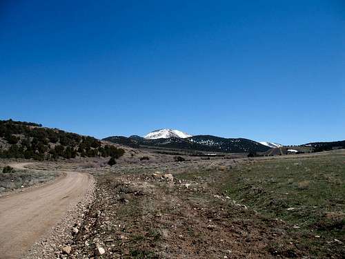
This is a mountain south of Vernon Utah and is located within the Uinta National Forest. I'd never heard of it until two weeks before I climbed it with Eric Willhite and I believe it was Eric that mentioned the name of this one to me initially. It was of interest to me as it is one of Utah's prominence peaks and barely gets on the prominence radar with 1041 feet of it,but that is still more than enough. Coming in at #321 out of #359, it would seem to be rather unimportant yet the view from the summit is truly amazing, as is often the case with a prominence peak.When heavy snow blankets the Wasatch mountains to the east of where I live, I like to find out of the way places to visit and explore as well as a mountain peak to hike or climb and if it is on one of my "to do" lists, so much the better. Located to the west of Eureka Utah, south of Vernon Utah, it is located less than 90 miles from Salt Lake City but yet it is in an area that most consider as part of the western Utah desert. The sign indicating that you are entering the Uinta National forest is almost comical because as you pass the sign, there isn't a tree in sight, only sagebrush. Even Sabie Peak itself had limited trees.
Getting There


Probably the easiest way to get to Sabie Mountain is to take exit 279 off of I-15 and head west on highway 68 as it goes through Lehi. Continue on past 5 mile pass and take the Pony Express highway towards Faust. After Faust, take a left hand turn onto highway 36 as it heads south and drive past the small town of Vernon. Go south 0.6 miles to Benmore sign. A sign indicating Vernon Reservoir campground is in place as well. Turn right at sign onto a dirt and gravel road and go 5 miles to a "T" intersection and Vernon Creek sign. Turn left and go 2.1 miles to the campground and lake. You can actually hike from the campground (see map aat the bottom of this page) or drive 1.7 miles to FS road 577 and drive fairly close to the western ridge approach.

Route


This is one of those peaks that you could most likely climb from any direction but the best way to get the summit is from the west since the forest service road, 577, snakes along the base of mountain there. From where we parked, it was less than a mile to the top with an elevation gain of over 1100 feet. If you don't feel that that is enough of a workout, you could go up, descend and then do it again. ; )
Another possibility is to hike up from the Vernon reservoir. That would make it a good 8 mile hike roundtrip and add about 800+ feet of elevation gain to the overall effort to make it almost a 2000+ foot effort (there would be some ups and downs via this route). So, there are options. I personally like the idea of hiking up from the reservoir while my wife camps out.

See the map at the bottom of this page for a nicely done route. Thanks to Eric Willhite for providing the map (see comments in additional information section below).
Summit Stuff and The views
I'm glad to see that this mountain is getting some visits now. See the register at the left side of this page and Lists of John has a few others as well. Sam Grant posted his GPS track (2015 visit) Looking to the north
 Looking to the south
 Looking to the east
 Looking to the west
 Eastward
Red Tape
Sabie Mountain is in the Uinta National forest. More information can be found bycalling:
Spanish Fork Ranger Station
44 West 400 North
Spanish Fork, Utah 84660
801-798-3571
 Deer tracks
 Camping
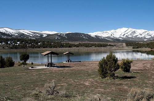
One campground can be found near Sabie Peak, the Vernon Reservoir. While the name doesn't sound exciting, it is a nice spot and provides the basics that
are needed. Tables, potty, and a bit of scenery. Here's more, taken from the offering that the Uinta National forest site offers:
CAMPGROUND NAME: Vernon Reservoir
RANGER DISTRICT: Spanish Fork NEAREST CITY/TOWN: Vernon
GENERAL COMMENTS: The elevation is 5,200 ft.Its a first come, first served CG.
The campground is in the Wasatch National Forest, but administered by the Uinta National Forest. The campground circles the Vernon Reservoir with most camp sites located on the northeast side. The surrounding hills are covered with sagebrush and juniper but there is only grass vegetation (and dirt) in the campground. Ramadas at each table provide the only shade. The campground is popular with anglers and ATV campers, and is sometimes under maintained. SEASONS: Open All Year
RATE AND MAXIMUM STAY PERMITTED Rate: No charge / Maximum Stay(days): 16
Sites 11 (Tent Pads)
No. Tables on Sites: 11 No. Grilles on Sites: 11
RV INFORMATION Hookups: None /RV Pull Throughs: 3
Parking aprons are either parking lot style or not clearly defined. The interior road is rough and challenging. The campground is not well suited for large RVs.
FACILITIES Vaults: Yes
Water Spigots (non-site): 3 No. Threaded: 3
WATER SPORTS Lake: Yes Swimming (provided)
Boat Carry Down Access: Yes
Power Boating: No
Vernon Reservoir is 20 acres.
FISHING Rainbow trout
There you have it, pretty bare bones but very adequate if you need a spot to camp. Nearest motels can be found in Spanish Fork, Provo and other cities nearby. None in Vernon or Eureka.
Additional information
Eric Willhite, a fellow SP member, has put together a very helpful website, that while apart from summitpost, offers additional information and pictures and Eric always includes a great map. For Eric's page on Sabie Mountain, click HERE.For his most recent addition on prominence
peaks in Utah, click HERE.

Eric and I climbed this one together although it was not planned that way. I had monday off so I had toyed with the idea of driving out the Pony Express highway beyond Lookout Pass and going after Round Top Mountain, a prominence peak near Dugway Proving grounds. When my wife decided that she would like to ride along, I shifted to Sabie as it was a bit closer and I figured the Vernon Reservoir had restroom facilities that might come in handy for her. We decided to leave at around 10 a.m.
Eric, on the other hand, had planned to leave his place with his two children
around one p.m. but instead got an earlier start and left pretty much about the same time my wife and I did. He had thought about doing either Pinyon Peak or Maple Mountain with Sabie Mountain as an alternative. As it turned out, he selected Sabie and so we were both totally surprised when we arrived at the same spot just a few minutes of each other. That made this one a lot more fun and we both wondered if more than two people climb this peak very often. We found no register on top although we did find two witness benchmarks and a cairn along with some old wood and wire. I left a register for those who might decide to venture to the top of this one in the future. The views from the top were outstanding.
Weather (closest resource)

Nearby peaks
If you make a visit out to this area, here are some other nearby peaks that you could include during a visit (plan on a couple days at the Vernon Reservoir campground:Each of the following has a summitpost page
Black Crook Peak (P2K)
Boulter Mountain (P2K)
Pinyon Peak (P1K)
Maple Peak (P1K)
Also some good smaller ones with lesser prominence abound in the area and can be nicely found using Lists of John information.
ZeeJay had a great day as indicated by her register entry:
"Did 5 separate little hikes including Sabie Mt. First did 6965. Then 7474, Maple, and 7270 together, starting from the Cherry Creek Rd. Then drove a short distance north on #005 and made a side trip west to 7655. Continued north on #005 and made a side trip to J Hill. Finally, made it up Sabie Mt starting from #005."
 Looking back down the route
 A fun hike
Sabie Mountain map
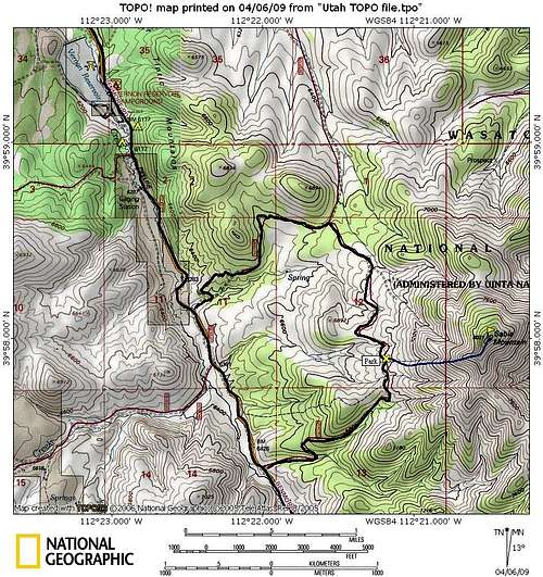 Map of Sabie Mtn as provided by Eric Willhite