|
|
Area/Range |
|---|---|
|
|
47.63833°N / 90.75417°W |
|
|
Hiking, Trad Climbing, Sport Climbing, Toprope, Bouldering, Ice Climbing, Aid Climbing, Mixed, Scrambling, Canyoneering, Skiing |
|
|
Spring, Summer, Fall, Winter |
|
|
1688 ft / 515 m |
|
|
Sawtooth Mountain Range, Minnesota, USA
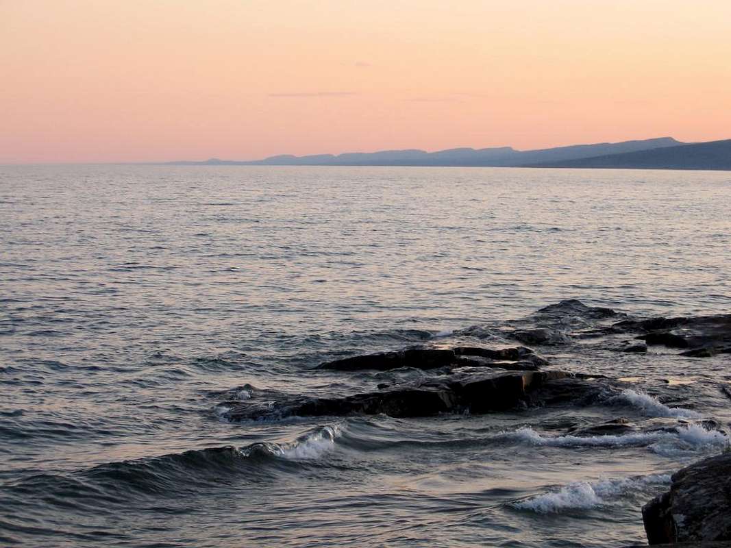
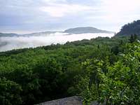
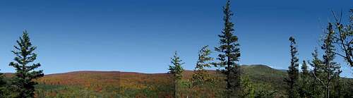
OverviewThe Sawtooth Mountains are a range of low, serrated ridges situated on the North Shore of Lake Superior in the U.S. state of Minnesota. They rise from Lake Superior at angles between 8 and 20 degrees and drop off steeply on their north sides. They received their name as a result of their relatively uniform size, angles, and regularity of spacing; seen from Lake Superior to the east, "the visible crest line thus presents a remarkable profile, resembling the teeth of an immense saw." |
||||
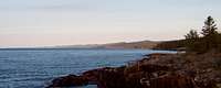
The Mountains of the Sawtooth Range
|
||||
Geology of the Sawtooth RangeThe Sawtooth MountainsThe bedrock exposed along Lake Superior's North Shore has a geologic history that goes back some 1.2 billion years. During the mountain-building, volcanic activity of that time, molten lava poured through great fissures that developed in the earth's crust. One particular flow complex, the Brule River rhyolite flow is thought to be as much as 3,500 feet thick. As these flows accumulated, the land along the rift zone sank to form a great basin, presently occupied by Lake Superior. Long periods of erosion followed. The local Sawtooth Mountains of the Grand Marais area in Minnesota are the remnants of this ancient mountain range. More recently, glaciers also took their toll on the area as massive ice sheets gouged out basins and scoured the surface of the bedrock. Superior Upland ProvinceEvery continent has a core of very ancient metamorphic rocks. The Superior Upland Province is the southern extension of the Laurentian Upland Province, part of the nucleus of North America called Canadian Shield. The basement rocks of the Laurentian Upland Province were metamorphosed about 2,500 million years ago in a mountain-building collision of tectonic plates called the Kenoran orogeny. The rocks of the Superior Upland are mostly Precambrian metamorphic rocks and overlying Paleozoic rocks (Cambrian) covered by a thin veneer of glacial deposits left behind when glaciers melted at the end of the Pleistocene Ice Age. If we could strip away all of the younger rocks deposited on top of buried Precambrian basement, you would see a landscape of low relief. The topography of the Precambrian rocks is very subdued, with barely 500 feet difference between the highest point and the lowest. Clearly, this region was exposed to a very long period of erosion in the very distant past which beveled the original mountainous surface to a gently undulating surface. The present surface is not much different. Hills rise just a few hundred feet above the surrounding countryside. The highest of these, such as Rib Hill, Wisconsin, are made up mostly of resistant quartzite or granite. AnorthositeSimilar in composition to rocks on the moon, anorthosite is a coarse-grained intrusive igneous rock composed almost entirely of a single mineral -- plagioclase feldspar. In Minnesota, anorthosite was intruded into the lowermost lava flows that formed during the opening of the Midcontinent rift. Anorthosite is part of the Duluth Complex and the closely related Beaver Bay Complex exposed along the North Shore of Lake Superior. Split Rock Lighthouse sits atop an outcrop of anorthosite. |
||||
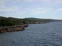
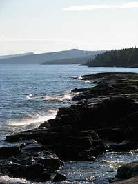
State Parks, Trails and Campgrounds of the Sawtooth Range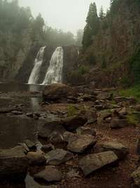 High Falls at Tettegouche State Park 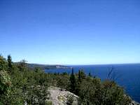 Shovel Point.  High Falls on the Pigeon River Cascade River State ParkAptly named, the Cascade River flows down one ledge after another for a total drop of 900 feet in the last three miles of its journey to Lake Superior. The park setting is a boreal hardwood-conifer forest of aspen, birch, fir, spruce and cedar. Visitors can stand on the footbridge that spans the river, or at any of the viewing spots above the river, and feel the vibration of the rushing torrent of water as it cascades down a volcanic canyon. The geology of the North Shore and the Cascade River is complex. It started billions of years ago when the ancient bedrock was covered with molten lava from volcanoes. Later, shallow seas covered the area and deposited sediment over the lava beds. The sedimentary rock formed from the seas was bent by great mountain building forces. Other complex geological processes took place before the glaciers scoured the area several times leaving the present Lake Superior basin. Gooseberry Falls State ParkGooseberry Falls is the gateway to the North Shore. It is known for its spectacular waterfalls, river gorge, Lake Superior shoreline, Civilian Conservation Corps log and stone structures, and north woods wildlife. George Crosby Manitou State ParkGeorge Crosby Manitou State Park is a country wilderness park where waterfalls cascade through a volcanic canyon surrounded by majestic forest. Volcanoes spewed fiery lava which cooled and built up in thick layers. Later, when glaciers moved down from the north, they scraped and dislodged the rock. As the melting glacier retreated, they left piles of rock and soil again changing the shape of the park. The last glacier left a large meltwater lake behind the shoreline ridge which drained into Lake Superior. This drainage route is now the Manitou River. Split Rock LighthouseThe magnificent bluffs upon which the lighthouse is built are formations of anorthosite. The bedrock is a result of ancient lava flows. Then over an immense time span, many complex geological processes occurred. Water covered the area depositing sediment over the bedrock. Later this rock was bent and compressed by mountain-building forces. Eventually a series of glaciers scraped the landscape, scouring out the Lake Superior Basin and shearing off the shoreline cliffs. Then the meltwaters of the glaciers flowed over the upland rock cliffs, carved away the less resistant rock and filled the basin we know as Lake Superior. Temperance River State ParkThe Temperance River has cut deep potholes in and along its riverbed and is surrounded by beautiful forest. Hike the trail to Hidden Falls or connect up with trails into the Superior National Forest and the Cross River Wayside. Carlton Peak, a recent addition to the park, is popular with rock climbers and offers even more recreational opportunities to park visitors. Tettegouche State ParkShovel Point; rocky, steep cliffs and inland bluffs; the cascading 60 ft. High Falls of the Baptism River; and the historic Tettegouche Camp all make Tettegouche State Park a hiker's paradise with miles of trails that overlook the Sawtooth Mountains and wind down to inland lakes accessible only by foot. Superior Hiking TrailThe Superior Hiking Trail (SHT) is a 205-mile long footpath that follows the rocky ridgeline above Lake Superior in northeastern Minnesota from Two Harbors to the Canadian border. The trail has 81 backcountry campsites. There are no fees, reservations, or permits required to hike or backpack on the trail. Dogs are allowed on the trail but must be on a leash at all times. |
||||
Winter Activities in the Sawtooth Range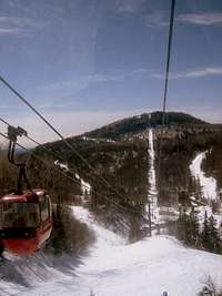 Lutsen Ski Area Downhill SkiingLutsen ski resort is a downhill ski and snowboard area located in the Sawtooth Mountains. Lutsen receives natural snow, at times lake effect snow from the Great Lake Superior located at its foot, and also has snowmaking equipment. The ski season extends from November into mid-April, longer than most other resorts in the Upper Midwest. Lutsen has four mountains, named Eagle, Ullr, Mystery, and Moose. Eagle should not be confused with Eagle Mountain, the highest point in Minnesota, which is actually in the Boundary Waters Canoe Area.
Nordic SkiingStep outside, strap on your boards, and discover Minnesota's public cross-country ski trails. You'll find a variety of terrains that are sure to appeal to every age and skill level. Ice ClimbingThe Sawtooth Range is host Minnesota's best natural ice falls: Nightfall and Cascade Falls. Grand Marais, MN is home to the (almost) annual Gentlemen's Occassional - a gathering of kilted Minnesota ice climbers. The gathering mixes ritual climbing of Nightfall (in kilts) and large amounts of alcohol later on. |
||||
Rock Climbing in the Sawtooth Range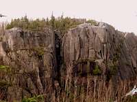 Section 13 Crags 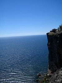 A rock climber at Palisade Head. 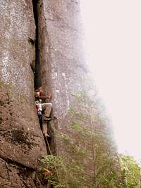 Gollum's Stairwell, Wolf Ridge. Palisade HeadPalisade Head is within Tettegouche State Park but not contiguous with the rest of that park. It is the most serious and richest rock climbing crag in Minnesota. With very few climbs easier than 5.8 and the bulk of climbs harder than 5.10. Climbs in the Amphetheatre tend to be the most popular and crowded and are also most easily visited by tourists. Plenty of crack systems to be found along the entire top of the Head to build anchors. If you are not feeling confident, a pair of ascenders is a good idea. Take note that the Southern Ramparts area is generally closed early in the season for Falcon nesting. Palisade Head is located at mile marker 57 on Minnesota Highway 61. Shovel PointThere are twenty-five listed climbs in the Rock Climbing Minnesota and Wisconsin guide book by Mike Farris. The Western section will be west and closer to the parking lot. The Eastern section will be east and closer to the "Point" and the lake. Any fixed pins found on this cliff system are likely to be very old so one should not rely solely on them. Consider padding sharp edges as well as the rhyolite of this area can wreak havoc on climbing rope. To get to Shovel Point take Minnesota Hwy. 61 north from Silver Bay about 4.5 miles to the rest area at the entrance to Tettegouche State Park. From here follow the well-signed trail to Shovel Point. Lake County Road 6 AreaThis area is comprised of two crags, Sawmill Dome and Section 13. These two anorthosite cliffs hold a number of good climbs up to 100 feet. The rock here is sharp so tape for your fingers and a pad for your rope would be wise. Carlton PeakThe rock is anorthosite, very strong, but also very abrasive. The climbs are primarily top-rope or trad-leads. No bolts. None of the climbs are named, but are numbered and info is available in the Minnesota and Wisconsin Falcon Guide by author Mike Farris. Wolf Ridge ELC AreaTwo separate crags make up the Wolf Ridge area - Wolf Lake (Johnson Lake) Set and Mystical Mountain Zone. Both fall on private land but are open for climbing as long as you register at the office first. The climbs at Mystical Mountain are tall and require a top belay if top roping and full length ropes to rap off. |
||||
Agencies and Organizations in charge of the Sawtooth Range Carlton Peak Info Sign 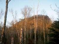 Carlton Peak Superior National ForestOver 445,000 acres or 695 square miles of the forest is surface water. In addition, more than 1,300 miles of cold water streams and 950 miles of warm water streams flow within the boundaries of the Superior. Fish species such as walleye, northern pike, smallmouth bass, lake trout, brook trout, rainbow trout, and brown trout can be found in abundance in these waters. The northern forest community thrives with its pine, fir and spruce trees and is home to numerouse wildlife species including deer, moose, the gray wolf, and black bear. Superior Hiking Trail AssociationThe Superior Hiking Trail is built and maintained by the volunteer-based Superior Hiking Trail Association (SHTA). Access FundThe Access Fund is the national advocacy organization that keeps U.S. climbing areas open and conserves the climbing environment. Founded in 1991, the Access Fund supports and represents over 1.6 million climbers nationwide in all forms of climbing; rock climbing, ice climbing, mountaineering, and bouldering. |
||||
External Resources for the Sawtooth Range
 Oberg Mountain, Sawtooth Range, Minnesota, USA. Photo 2007, by tab01 Oberg Mountain, Sawtooth Range, Minnesota, USA. Photo 2007, by tab01 |
Bibliography and Credits Sunrise on Britton Peak.
|
|||