

-
 19329 Hits
-
 85.87% Score
-
 21 Votes
|
|
Mountain/Rock |
|---|---|
|
|
46.80000°N / 10.96000°E |
|
|
11614 ft / 3540 m |
|
|
Overview
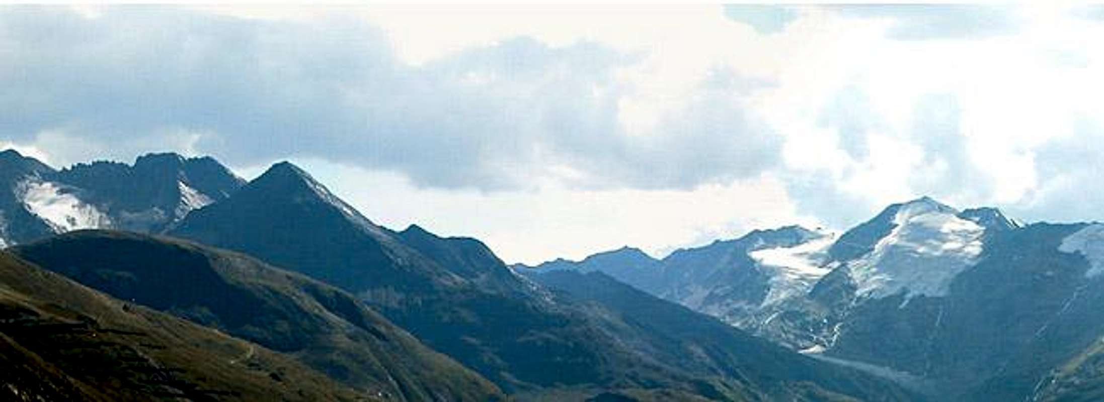
Schalfkogel is one of the principal summits in the southernmost part of the Ötztal Alps.The mountain itself shows a steep ice and rock face to the east, a broad glacier covered north-face and appears pyramid shaped when seen from the west. Surrounded by Hohe Wilde, Similaun, Kreutzspitze and Ramolkogel, it is one of the best and most interesting lookout peaks of the region. Given the fact that it is also surrounded by mountain huts it is also a very popular summit, especially in the summer months. The three ascent routes are not supposed to be overly difficult, however the glaciers surrounding Schalfkogel show a lot of crevasses.
Though located very close to the Italian border the usual ascent routes all start from the Austrian side, meaning a long drive through the Ötztal Valley to either Gurgltal or Venter Tal. The trailheads at the villages of Obergurgl and Vent are both located at about 1800m so that a single day ascent, while not impossible, would be a tour de force. Overnight stays at one of the four huts listed below therefore are mandatory.
The mountain was first ascended by F. Mercey in 1839.
 |  |  |  |
Route Overview
There are three "classical" routes up Schalfkogel, each starting at one of the three huts which surround it
This route starts from Hochwildehaus. It crosses the Gurgler Ferner Glacier keeping almost level. A short rocky (but brittle - watch out!) section starts the climb which then goes along the Kleinleitenferner Glacier to Schalfkogeljoch Pass (sometimes called Schalfjoch). The final ascent leads along the Schalfkogel south ridge which is rocky, but often covered with ice and snow even in late summer.
The route starts from Ramolhaus and crosses Firmisanjoch Pass, which can be reached by two routes. One crosses the southern slopes beneath Ramolhaus towards the Firmisanschneid Ridge. Below the ridge a small glacier (lots of crevasses) has to be traversed to reach the pass. The second route circumvents the glacier on its eastern side and reaches Firmisanjoch by a steep rocky scramble directly from the east. From the pass follow the broad ice covered north ridge towards the summit.
This Route starts from Martin Busch Hütte. This route starts by crossing the lowest part of Marzellferner, heading for the central part of the Big Schalfferner Glacier. Follow this in the middle to the spot where Kleiner Schalfferner is located directly to the east. Leave Großer Schalfferner here and cross the end morrains of Kleiner Schalfferner along the central part of which the ascent leads to Diemjoch Pass (between Hinterer Diemkogel and Schalfkogel). The remainder of the ascent follows the rocky Schalfkogel west ridge.
 |  |  |
Getting There
From Innsbruck (east) or Bregenz (west) follow motorway E60 in the direction of the direction of the respective other city. East of Imst (exit 123) turn south on B186 through Ötztal.- For Vent (Martin Busch Hütte) turn westward through Venter Tal right after you have gone through Sölden.
- For Obergurgl (Hochwilde Haus, Ramolhaus, Langtaleregg Hütte) turn off westward from B186 at Untergurgl.
The Hut ascents are marked and straightforward.
Red Tape
There is no red tape that I'm aware of.When To Climb
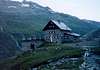
Schalfkogel can be climbed all year round. The best hiking time is July through September. Winter ski tour ascents are possible from all huts. They converge in Schalfjoch, which can rather easily be reached. The final 200m of elevation are demanding, however.Mountain Huts and Refuges
There are four huts in the vicinity of Schalfkogel. The following table lists the necessary hut info:| Refuge / Hut | Height | Open | Tel. |
| Hochwilde Haus | 2883m | beg July - mid Sept. | +43/5256/6233 |
| Martin Busch Hutte | 2501m | end June - end Sept. | +43/5254/8130 |
| Ramolhaus | 3006m | beg July - end Sept. | +43/5256/6223 |
| Langtaleregg Hütte | 2883m | mid July - end Sept. | +43/5253/5396 |
 |  |  |  |
Accomodation
Camping is not allowed in the vicinity of the summits. You should rather visit the huts. In summer, when the huts are full, often you are allowed to camp out near them.As for getting rooms and appartments you'll probably encounter no problems. Ötztal is a heavily touristic region (especially in winter) and offers lots of accommodation possibilities. Just click on the following link to be directed to the accommodation page of the official site.
Weather Conditions
Follow one of the links belowMaps 'n' Books
Maps- Inneres Ötztal-Gurgler Tal - Venter Tal - Pitztal
Kompass Map WK042
1:25.000
Kompass Verlag
ISBN: 3-85491-600-0
- Ötztaler Alpen
Kompass Map WK43
1:50000
Kompass Verlag
ISBN: 3-85491-049-5
- Ötztaler Alpen, Gurgl
Alpenvereinskarte 30/1
1:25000
Books
- Ötztaler Alpen
Alpenvereinsführer
W. Klier
Rother Verlag
ISBN: 3-7633-1123-8
Remco Woutersen - Feb 7, 2006 8:08 am - Hasn't voted
Untitled CommentIn 1999 three friends and I descended from the Schalfkogel to the Martin Busch hütte. When we got to the tongue of the big Shalfferner it was not possible to leave the glacier on the southside (the left bank) because there was a wall of ice about 45 degrees steep with falling rocks every few seconds. Because of this we left the glacier on the north side. This was without problems except for the fact that we had to cross the Schalfbach in order tot get to the hut. The Schalfbach isn't a small river though, it is a meter deep and you could hear rocks being swept away in the water. We had to spend a night in the open so we could cross the stream in the morning when it was less deep!
In conclusion, if the conditions aren't much different then we found them I would advice against this route, especially in descent. Ofcourse in a year with a lot of snow getting to the south bank of the glacier is a lesser problem. I also do not know what 2003 did to this glacier, so maybe the problem is gone by now.
dmiki - May 3, 2009 4:14 pm - Hasn't voted
Six Czech/Slovak climbers killed in Austrian Alps avalanchehttp://newsfeedresearcher.com/data/articles_w19/avalanche-czechs-austrian.html http://news.yahoo.com/s/afp/20090503/wl_afp/austriaavalancheczech http://news.yahoo.com/s/nm/us_austria_avalanche;_ylt=AmwxeSzLmYWXMzvBAt9z0lfmWMcF RIP