
-
 9363 Hits
-
 81.18% Score
-
 13 Votes
|
|
Mountain/Rock |
|---|---|
|
|
41.33770°N / 106.32957°W |
|
|
Trad Climbing, Scrambling |
|
|
Summer |
|
|
11475 ft / 3498 m |
|
|

Overview
What is awesome about Wyoming’s Snowy Range is that trailheads start between 10,400’ and 10,800’, the highest point is a little over 12,000’, trails are short, and there are many rock faces and snow-filled couloirs. For mountaineers that enjoy technical rock, snow, or both, this means that the Snowy Range is a virtual alpine paradise-- all the fun and challenge but without the long, hard approaches. And even though the area is popular, you don’t see too many people off the maintained trails.
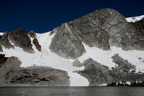
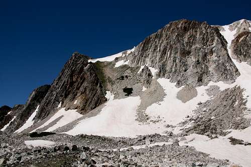
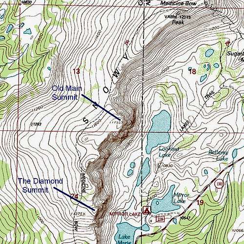
Of all the rock faces south of the summit of Medicine Bow Peak, the Diamond is perhaps the most spectacular and the best known. How it got its name is something I do not know, but I suspect it has to do with one or both of these: the shape of the face, or the way the quartzite that comprises it gleams in bright sunlight.
An interpolated elevation for the summit would be 11,460’. My GPS device gave me 11,475’. The Diamond is directly west of the south shore of Mirror Lake as seen on the USGS Medicine Bow Peak quad.
A climb of the Diamond's face can be up to about 900'. Considering the altitude, terrain, weather, and quick access, the Diamond is a great place to climb just for climbing's sake or to train for alpine-style climbs on bigger mountains.
A Touching Story

Near the summit, there is a memorial plaque (it is either on an east-facing or south-facing rock, but I can’t remember for sure; I found it by accident in 2009 and didn’t look for it when I was back in 2010), and there is a powerful story behind it. Normally, tales of tragedies befalling strangers do not get to me much, but I must have at least a little something other than stone in my heart, for the story brought me close to tears when I read it.
Here is the short of it--
The four people memorialized died in a boating accident in Canada's Baffin Bay. Returning from an expedition to Baffin Island, the group, along with their Inuit guide, was checking out a pod of whales. The whales dived, and one breached directly beneath the boat. The group was unable to right the boat, and the four named on the plaque eventually succumbed to the freezing waters. Michael Moe was the last to perish, after holding on, even joking, for over eight hours. The guide survived after 18 hours at sea; he had been wearing a marine survival suit, but the others only had been wearing life jackets.
The source of this information is a moving article by adventurer and writer Mark Jenkins; Michael Moe was his best friend and a climbing/exploring partner for over 20 years. Jenkins and other friends of the deceased placed the memorial plaque. Why on the Diamond? Jenkins and Michael Moe had climbed there together for years, using its challenging rock routes and nearby couloirs for both training and fun.
The article has more details about the accident. Those details are on the sixth and final page, but the entire article is very much worth reading to get a sense of who Michael Moe really was and how he seized upon adventure in life.
Thanks go to Tracy for directing me to this information.
Marie Couloir and the Diamond from Lake Marie
Technical Rock Climbing
The Diamond has several established climbing routes. On its page at rockclimbing.com, you can find notes for three of them (as is typical of the site, useful photos and information are sparse). Mountain Project has only two of the routes, but the details are much better (it has Red Spot and Sidewinder, the latter as 5.6).
Left Over-- 5.7
Left Over Direct-- 5.10a
Red Spot Route-- 5.5
Just south of the Diamond, separated from it by a gully/dihedral, is Diamond Buttress, which has two routes documented on rc.com:
Flying Buttress-- 5.9
Sidewinder-- 5.7.
This site has even more routes and has information on other rock faces as well. Note that it puts Sidewinder at 5.8, so you have at least three different sources placing that route from 5.6 to 5.8. This third site seems to be by someone very familiar with the range and climbing in it, and it appears to be the best of the three sources by far.
Reaching the Summit
Other than climbing the face, there are at least three decent ways to reach the summit:
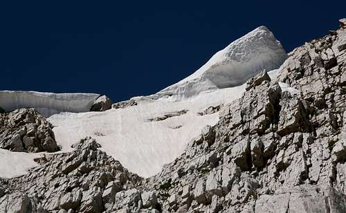
Scrambling/hiking to the top-- On the right (north) side of the face, there is a prominent buttress (do not confuse this with Diamond Buttress) that from certain angles looks like part of the Diamond itself. Climb this buttress (lots of Class 4, low 5-- the closer you stay to the crest, the harder and better) until it ends about 100 vertical feet below the summit of the Diamond. From there, ascend to a snow headwall and climb it (maybe 15-20’ high, almost vertical-- get ready to swing the pick hard and deep) and then make an easy scramble to the highpoint, or traverse to the base of the snow (as seen in a picture on this page-- conditions can vary) and climb low Class 5 rock on the Diamond proper to easier ground just below the summit. I climbed both ways for a fuller experience (and the ability to pass the information along).
Alternatively, one can hike up the scree-filled couloir just right of the buttress (in early July of a year with heavy snow accumulation, this couloir was mostly melted out). It is easy but loose Class 2 going (I used this as a descent route), but you still have to face the decision of the snow headwall or the low Class 5 on the Diamond proper at the end, for the scree slopes end at the base of the headwall (in late summer, the snow might be gone, leaving a steep and likely loose and muddy slope).
Pictures on this page show all of these options.
 |  |  |
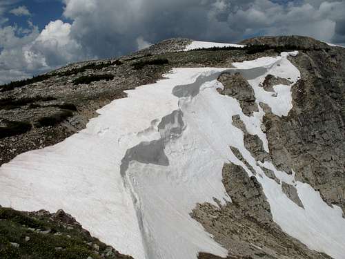
Snow climbs-- From Lake Marie, climb Marie Couloir, a short distance south of the Diamond, and then hike north to the summit. Or hike a little more to the north to access the Lookout Couloirs and then hike south from the top of the one you climb. These are more-than-honorable ways of climbing the Diamond.
Trail hike-- The third is to leave the Medicine Bow Trail while going to or from the summit of Medicine Bow Peak and walk over for 20-30 yards to peer down the sheer cliffs and steep couloirs.
Getting There
On WY 130, park at the Mirror Lake Picnic Area and pick up the Lakes Trail. This is about 28 miles east from the intersection of WY 130 and 230 south of Saratoga, and it is about 13 miles west of Centennial.
If the picnic area is closed, and I have seen it so several times, park a very short distance west at Lake Marie East Trailhead.
There are other places from which to approach the Diamond, but those described here are the closest.
Distance and Elevation Gain
From trailhead to summit, the distance is not even 1.5 mi, and there is almost no trail approach. Hike the Lakes Trail a short distance and then strike out to the base of the Diamond, boulder-hopping across the basin between Lake Marie and the unnamed lake just south of Lookout Lake. From the base, the climb was 0.7 mi, with 600’ of elevation gain. Total elevation gain from the trailhead is approximately 1000’.
Red Tape and Camping
There was no fee at the Mirror Lake area in 2010, but there is a day-use fee at the nearby Sugarloaf area. Because this is a very popular area, I wouldn’t be shocked to see fees appear elsewhere.
The Forest Service wants people to stay on the trails in order to minimize impact on the alpine vegetation. Since climbing the Diamond obviously involves off-trail travel, please make a great effort to stay on rocks and snow as much as possible and be as gentle as possible on the vegetation when you can’t.
Old maps, including the Medicine Bow Peak USGS quad, show campgrounds at Lake Marie and Mirror Lake, but there aren’t any there now. There are several national forest campground along or shortly off WY 130, though. The closest is Sugarloaf, a few miles east. The spur road to Sugarloaf is often blocked by snow into August, and the campground is closed when that is the case. You can reserve sites there at recreation.gov.