
|
|
Area/Range |
|---|---|
|
|
22.42857°S / 44.84445°W |
|
|
Hiking, Mountaineering, Trad Climbing, Sport Climbing, Toprope, Bouldering, Big Wall, Mixed, Scrambling |
|
|
Winter |
|
|
9180 ft / 2798 m |
|
|
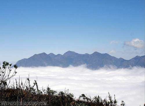
Serra Fina as seen from Itatiaia NP.
The Serra Fina, or Sierra Fina (portuguese for thin Sierra) coincides largely with the Alkaline massif of Passa Quatro city and it is situated on the border of the triple states of Minas Gerais, Rio de Janeiro and Sao Paulo along Serra da Mantiqueira, which is the geographic structure which contains it, and is adjacent to the massif of Itatiaia where is the famous Itatiaia National Park and Pico das Agulhas Negras, 5th highest peak in Brazil. It has one of the largest topographical unevenness of the Brazilian territory (above 2,000 m) and the fourth highest mountain in Brazil: Pedra da Mina.
The rocks that make up the mass formed in the transition between the Cretaceous and Tertiary geologic periods. This limit, which occurred around 65 million years ago, is marked by the extinction of the dinosaurs and many other groups of vertebrates and invertebrates as well as the field of early mammals and angiosperms (flowering plants) on the continental faunas and floras .
The mountains of the Serra Fina are linked to each other by a sequence of an interesting ridge formation. The higher elevations prefer the conical or pyramidal peaks showing wide or covered by rocks or grass the same way as its slopes are covered with grasses and bamboos. Characteristic of this alkaline igneous massif is the ease with which its rocks are fractured, resulting in many cracks, lacquers and loose stones, which are enjoyed by hikers to mark the paths. Very close to Pedra da Mina in both the west and east, plateaus appear at about 2.500 masl where water can be found easily. Streams are the Red Waterfall, Claro river and Verde river. The first one (red waterfall) presents water with strong taste of iron (the reason for its color) while the last one is the most abundant.

Night shot, Pedra da Mina summit camp.
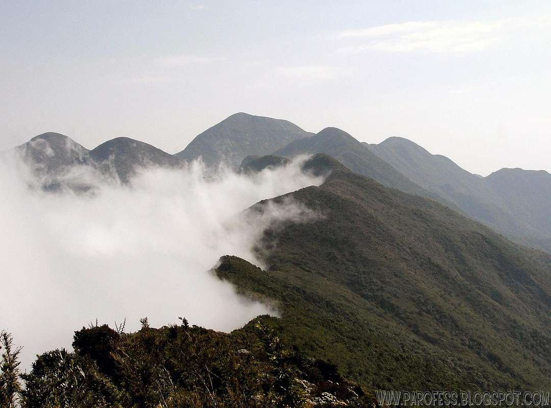
To the west we can observe the sequence of the Serra da Mantiqueira especially Itaguaré Peak with 2.334m and Marins Peak with 2.422m. To the east rises the majestic massif of Itatiaia where are easily observed Morro do Couto (2.680m), Prateleiras Peak (2.543m) and Agulhas Negras Peak (2.792m), which is the highest point of the State of Rio de Janeiro. The northern Serra Fina slightly decreases until it reaches the sea of hills of Minas Gerais State where are the cities taken as base for the hike of these mountains. The southern front, in a different way, drops dramatically in sharp ridges and deep ravines dying at the base of the Paraiba Valley, State of Sao Paulo. Highlights are the rocky walls of hundreds of meters high that give great contrast to the valley more than 2.000 meters below.
The vegetation of Serra Fina is characterized by the formation of Atlantic Forest in the first few hundred meters from its slopes and also in the deepest valleys that penetrate between the high elevations. It is also observed the appearance of the Pinheiro do Paraná (aka Araucária) - Araucaria angustifolia - that covers the rugged slopes benefiting of low temperatures imposed by altitude. Interested thinning the understory during the dry season indicating the lack of abundant rainfall compared with the forest closest to the ocean. The highlights are the bromeliads and orchids in particular Sophronitis coccinea, orchid small flower of reddish and strong tone, very common in high montana region, flourishing especially in the month of September. Above 2.000 meters of altitude alpine pastures arise basically covered by short plants, herbs and shrubs that are adapted to shallow and dry soil, also thriving on the rocks. Among these is the Capim Elefante (portuguese to elephant grass) occupying large tracts of land resembling the formation of the African savannah. These can grow to the height of a man, sometimes taller. Bamboos and taquarás are common where the soil has some level of depth. Small trees appear only in the areas where there is protection from the wind, except for a species that thrives vigorously in the midst of fields, forming a green canopy even in times of drought, not exceeding, however, three meters high. Highlight an orchid genus Oncidium releasing a rod composed of small yellow flowers from a large spherical bulb.
The fauna is not easily seen with the exception of the swallows. It may be noted, however, the presence of small rodents as well as the feces of small mammals. Closer to the observer arises Melanophryniscus moreirae, a red-bellied frog that does not exceed two inches long, found near the accumulation of water.

Getting There

Highest point of Serra Fina

Natural Mountaineer!
There is 3 possible ways to get to these mountains, and for each one of them, first of all, you have to manage your way to small cities nearby, but I'll show here just the traditional way, the start of the traverse route. So you must get to a small village named Passa Quatro.
From São Paulo, there is a couple bus companies that drive you to Passa Quatro for around R$ 45,00 (about US$ 20.00), and the ride takes up to 4,5 hours.
From Rio de Janeiro, pretty much the same cost and time.
Once you get to Passa Quatro, get yourself a private transport (very easy to find one, there is several vans just waiting for mountaineers at the bus station every weekend, especially between may and september) to one of the spots in red, depending of your choice:
First: SPOT: TOCA DO LOBO FARM: Starting the Serra Fina traverse from the west side. First summit: Alto do Campim Amarelo. This is the most traditional start of the traverse.
Second: SPOT: SITIO DO PIERRE: Starting the Serra Fina traverse from the northeast side route. First summit: 3 States Peak (1 night) and go from there in the next morning.
Third: SPOT: SERRA FINA FARM: Fewer people use this route for these mountains: Starting from Serra Fina Farm, hike up to Pedra da Mina by the north side, 1 night. Go from there and be ready for a really tough task, it is 9kms hike to get up there, full day job.
Red Tape
Take your garbage with you!!!Be careful, Serra Fina has a well known problem with water, find a gps archive to get the water spots, you don't wanna run out! During day time it is hot, but at the night, winter time, it can drop to -13°C. Cold!
In winter is easy to find the streams frozed in early morning.
What’s forbidden:
At all costs, don't make fire or deforest any places. Respect nature and wildlife please!
BE CAREFUL ABOUT SNAKES AND POISONOUS SPIDERS (BROWN SPIDER)
A GPS is highly recommended for that Sierra, on a foggy day you will be lost in no time.
Informational images
 |  |  |  |  |
Camping
Camping is permited anywhere you want inside the Sierra. Please look for ready camping sites along the traditional trailhead.Toca do Lobo Farm, Maracanã camp site, Alto do Capim Amarelo summit, valley after Morro do Melano (beside the red waterfall), Pedra da Mina summit, Pedra da Mina base, Ruah valley, small summit after Ruah valley, base of Cabeça de Touro Peak, 3 Estados Peak summit, and Sítio do Pierre. Plenty of places!
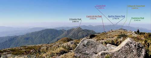
Panorama: east view from the summit of Pedra da Mina. 2.798 m.
Mountains 1: Pedra da Mina - 2.798m

Pedra da Mina is the highest point on that photo.
Pedra da Mina stands as the 4th highest brazilian mountain, and the highest point of Sierra Fina range.
To access the mountain page here at SP: PEDRA DA MINA
Mountains 2: Plane Crash Peak - 2.704m

PCP as seen from Mina summit.
Morro do Avião (or Plane Peak, or Plane Crash Peak) is a great rocky mountain directly southeast of Pedra da Mina Peak in Serra Fina, Brazil. Forgotten by the brazilian mountaineering community, hardly you hear someone say that reached its summit, but people do go there and the reason is obvious, there is a crash site close to the summit.
To access the mountain page here at SP: PLANE CRASH PEAK
Mountains 3: Point 2667 - 2.667m

Point 2667 as seen from the top of Pedra da Mina.
Point 2667 is a sub-summit of Mina Rock, it can even be called as North Summit of Pedra da Mina (Mina Rock). It's a mountain of Sierra Fina range, Brazil. Very popular mountain since it is the last highpoint you'll reach before Mina itself on the Paiolinho Route, a direct route to Pedra da MIna.
To access the mountain page here at SP: POINT 2.667m
Mountains 4: Pico dos 3 Estados - 2.665m

3 States Peak
Pico dos 3 Estados is the 10th highest brazilian mountain, directly north of Cupim do Boi Peak at Serra Fina, Brazil. The brazilian authority responsible for the mountains registry, IBGE, documents its altitude as 2.665 meters high. It is part of the traverse and a famous brazilian mountain and often visited.
To access the mountain page here at SP: 3 STATES PEAK
Mountains 5: Cabeça de Touro Peak - 2.649m

Cabeça de Touro Peak is the massive broken mountain close by on the left
Cabeça de Touro Peak, or Bull's head Peak if you will, is a massive rocky mountain directly southwest of 3 Estados Peak at Serra Fina, Brazil. Forgotten by the brazilian mountaineering community, hardly you hear someone say that reached its summit. The brazilian authority responsible for the mountains registry, IBGE, documents its altitude as 2.600 meters high.
To access the mountain page here at SP: CABEÇA DE TOURO PEAK
Mountains 6: Morro do Tartarugão Peak - 2.631m

Tartarugão Peak.
Morro do Tartarugão, or Big turtle Peak if you will, is a great rocky mountain directly southwest of Pedra da Mina Peak at Serra Fina, Brazil. Forgotten by the brazilian mountaineering community, hardly you hear someone say that reached its summit. The brazilian authority responsible for the mountains registry, IBGE, documents its altitude as 2.595 meters high.
To access the mountain page here at SP: BIG TURTLE PEAK
Mountains 7: Melano Peak - 2.566m

Melano Peak.
Morro do Melano, or Melano Peak is 2.566m high, and that makes it one of the smallest peaks of Serra Fina range, since the highest peak of the range and fourth brazilian peak is Mina Rock. Very popular mountain since it is the second highpoint you'll reach before Mina itself on the traverse route.
To access the mountain page here at SP: MELANO PEAK
Mountains 8: Cupim do Boi Peak - 2.532m

Cupim do Boi at left, Cabeça de Touro at right.
Cupim do Boi Peak is a broke rocky mountain directly south of 3 Estados Peak at Serra Fina, Brazil. Forgotten by the brazilian mountaineering community as a summit itself (not really a mountain, but the highest point of a ridge and it has the shape of a sharp mountain after all), hardly you hear someone say that summited. They pass by its summit without any care for the mountain and not even a summit shot!
To access the mountain page here at SP: CUPIM DO BOI PEAK
Mountains 9: Alto dos Ivos Peak - 2.524m

Alto dos Ivos in lovely sunset lights!
Alto dos Ivos Peak, or "High Ivos Peak" if you will, is a mountain of Sierra Fina range, Brazil. Very popular mountain since it is the last summit of the famous traverse, Sierra Fina traverse. The brazilian authority responsible for the mountains registry, IBGE, doesn't document its existence.
To access the mountain page here at SP: ALTO DOS IVOS PEAK
Mountains 10: Capim Amarelo Peak - 2.500m

Capim Amarelo rises poiting to the sky!
Capim Amarelo Peak, or "Yellow Grass Peak" if you will, is a huge mountain of Serra Fina, Brazil. Very popular mountain since it is the first summit of the famous traverse, Serra Fina traverse. The brazilian authority responsible for the mountains registry, IBGE, documents its altitude as 2.390 meters high. This is very much wrong, everybody here knows the right altitude is 110 meters higher then that.
To access the mountain page here at SP: CAPIM AMARELO PEAK
Weather Forecast
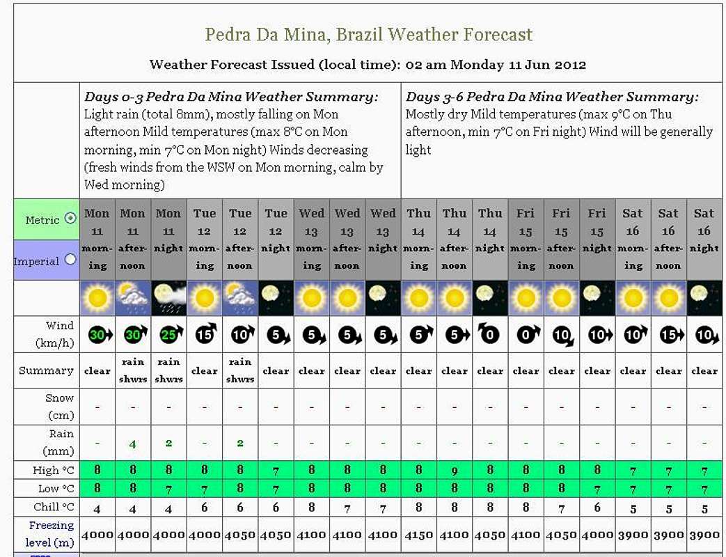
The weather forecast is based on the summit of Pedra da Mina, which lies right at the middle of the Sierra. Click over the image to jump to the WF website.
Legal Issues
To hike/ climb is a dangerous activity and requires proper equipment and clothing, the owner of this page cannot be blamed by injuries caused to anyone who read this page for its info about the mountain, and eventually got hurt by doing so with reckless behaviour or bad weather conditions.
Paulo Roberto Felipe Schmidt – AKA: PAROFES
External Links
My youtube channel: www.youtube.com/parofes - Now with 270+ videos online!The biggest brazilian website about climbing and mountaineering, for which I'm a columnist: