
|
|
Mountain/Rock |
|---|---|
|
|
44.04513°N / 113.56375°W |
|
|
Custer |
|
|
Hiking |
|
|
11401 ft / 3475 m |
|
|
Overview
 Shadow lake peak behind fall colors.
Some Mountains Just Can’t Be Ignored even if the highest you’ve ever climbed is to the top a public toilet bowl to write words of wisdom for your peers.
A few years ago, while hiking out after a trip up USGS peak, I bumped into an overweight, Oly swilling couple from Blackfoot on a day ride with Teeny their Cocker Spaniel. They were sitting on their ATV’s parked near the trailhead and admiring the North face of Shadow Lake peak. I was given a cold one in exchange for a family photo showing off the three with the mountain in the background.
Shadow Lake Peak cuts a stunning profile from the mouth of Long Lost Canyon in the Lost River Range. Standing tall and all alone at 11,401’ it’s ranked as Idaho’s 50th highest peak. If a climber isn’t sucked in by the sight alone, curiosity over an approach through a canyon named ‘Hell’ should finish the trick.
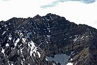
 The East and North Faces of USGS peak from the summit.
 Getting There
From Howe; Drive North on the Little Lost Highway about 30 miles to the “town site” of Clyde, turn left onto Pass Creek Road (gravel) and drive West for 7.5 miles to Dry Creek road, and then another 10 miles to the old Dry Creek Dam site. From there the road turns into a jeep trail. A high clearance vehicle with a short wheelbase will eek you past a short section of “western two track”. Most park at the dam and either Bicycle, Motorcycle or horseback from there. The road forks 2.6 miles past the dam. Take the left fork into Long Lost Canyon. Continue another 6 miles to Hell Canyon and follow a seldom maintained forest service trail into the canyon. Although this is a designated trail open for Two wheeled vehicles, it's steep, narrow and more suited for foot travel. A Forest service sign at the mouth of the canyon reads, Hell Roaring Canyon > The trail is far from Hell and the Roaring depends on season and snow pack. Follow the trail up hill, gaining more than 1,200 feet in a little less than 2 miles through a few green alpine meadows and you’ll arrive at Upper Shadow Lake. From there, Follow a steep but easy class two ridge to the summit. From the top, you’ll be rewarded with great views of the Lost River and Lemhi ranges.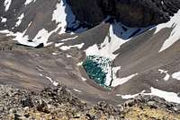 Shadow Lakes from the summit. The start of the class 2 ridge is visible in the lower left corner
From Mackay;
Drive 8 miles south from Mackay on U.S Highway 93 and turn East onto Pass Creek road. Drive over the summit and continue about 9.4 miles to Corral Creek, turn West and follow a good gravel road 7.5 miles to the old Dry Creek Dam site. From there follow the directions above.
There are several possibilities for snow routes on the north and north/west side of the mountain but any other route in the summer would require a long approach and a lot of Scree. Ross Peak is Less than a mile south as the crow crawls. The connecting ridge has a 50’- 70’ section of class five climbing but can probably be bypassed by a long down climb on the west side.
 The East Face of USGS peak from near the summit.
 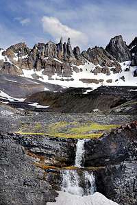 The cirque at the head of Long Lost Canyon.
 Camping
Unless your driving skills can get you past that short section of western two track, you should consider an overnighter, it’s a long drive into the old dam site and a long hike to the top from there. There are no designated camp sites within several miles, but this is a camp anywhere you please area. The dam site is mostly gravel, sage brush and sparse trees. Hike a few miles for much better options.
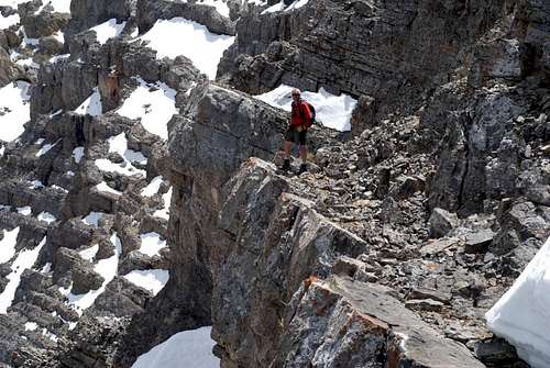 Brad above the class 5 mank on the ridge between the summit and Ross Peak.
 Links
Idaho-a-climbing-guideIdahosummits.com
Salmon-Challis-forest