
|
|
Mountain/Rock |
|---|---|
|
|
35.70679°N / 118.56071°W |
|
|
KERN |
|
|
Hiking, Mountaineering |
|
|
Spring, Summer, Fall |
|
|
7091 ft / 2161 m |
|
|
Overview
Shirley Peak is located on the Greenhorn Summit near Lake Isabella, California. Shirley Peak is adjacent to Alta Sierra at Shirley Meadows which is a snow park in the Winter. Trails and roads in the area are often used by hikers, mountain bikers, as well as the OHV community. To climb Shirley Peak one must first follow the directions to reach the parking area on the Greenhorn Summit.From the parking area(6770') you will see a marker on the East side of the road (as shown in the photo). Just past the marker is a fork in the trail, but take the right fork and stay on the overgrown road. Follow the overgrown road for about .1 of a mile and then climb due Northeast.
 The trailhead for Shirley Peak though the trail is overgrown. 08-09-2009
As you climb Northeast cross-country amidst dense trees you will cross a paved road, and then a dirt road. The summit (7091') is a pile of rocks, and there is no register there.
 The dense trees and undergrowth are really nice. 08-09-2009
The hike is 1 mile round trip with an elevation gain of 321 feet. You can either head down Southwest through the trees the way you came, or you can climb down 1 mile and do Cooks Peak which is on the same ridgeline as Shirley Peak.
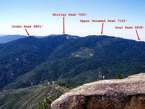 I took this photo of the Alta Sierra section of the Greenhorn summit from Black Mountain Point on August 9th, 2009.
Getting There
From Wofford Heights take SR 155, 7.7 miles to Greenhorn Summit.~I-5 North to Bakersfield, exit 178 east. Go to Lake Isabella and exit on SR155, follow signs to Wofford Heights.
~From Ridgecrest, Hwy 14 to 178 west, follow signs to Kernville, then go west on 155 to Wofford Heights.
~From 99 southbound, take 155 east to Greenhorn Summit, turn left on 24S15.
~It is also possible to take Rancheria Road from Highway 178 in Rio Bravo near Bakersfield though it is a dirt road for much of the way.
From the sand shed on the Greenhorn Summit take Rancheria Rd. South for 3 miles to Alta Sierra at Shirley Meadows parking lot. Drive .3 miles past, and you will see a small dirt parking area. You will see the trailhead on the East side of the road.
View Larger Map
Red Tape
This is not a wilderness area, so permits are not required.Greenhorn Ranger District
4875 Ponderosa Drive
P.O. Box 3810
Lake Isabella, CA 93240
(760) 379-5646
Tule River Ranger District
32588 Highway 190
Springville, CA 93265
(559) 539-2607
Camping
Evans Flat, Alder Creek, Rancheria Rd. & Cedar Creek.Camping & other lodging is also available in nearby Lake Isabella, Kernville, and Wofford Heights.
External Links
Weather from the National Weather ServiceWebcams
Lake Isabella Online